哈丁克斯費爾德-希森丹
荷兰南荷兰省市镇
| 此條目沒有列出任何參考或來源。 (2018年8月23日) |
哈丁克斯費爾德-希森丹(荷蘭語:Hardinxveld-Giessendam,荷蘭語:[ˌɦɑrdɪŋksfɛlt ˌxisə(n)ˈdɑm] (ⓘ))是荷蘭南荷蘭省的一個市鎮。2004年人口17,828。面積19.35 km²,其中2.44 km²為水域。
| 哈丁克斯費爾德-希森丹 Hardinxveld-Giessendam | |||
|---|---|---|---|
| 市鎮 | |||
 哈丁克斯費爾德的水塔 | |||
| |||
.svg) 哈丁克斯費爾德-希森丹在南荷蘭省的位置 | |||
| 坐標:51°49′N 4°50′E / 51.817°N 4.833°E座標:51°49′N 4°50′E / 51.817°N 4.833°E | |||
| 國家 | |||
| 省份 | 南荷蘭省 | ||
| 成立 | 1957年1月1日[1] | ||
| 政府[2] | |||
| • 行政機構 | 市議會 | ||
| • 市長 | Dirk Heijkoop (CDA) | ||
| 面積[3] | |||
| • 總計 | 19.35 平方公里(7.47 平方英里) | ||
| • 陸地 | 16.91 平方公里(6.53 平方英里) | ||
| • 水域 | 2.44 平方公里(0.94 平方英里) | ||
| 海拔[4] | 3 公尺(10 英尺) | ||
| 人口(1月 2019)[5] | |||
| • 總計 | 18,051人 | ||
| • 密度 | 1,067人/平方公里(2,760人/平方英里) | ||
| 時區 | CET(UTC+1) | ||
| • 夏時制 | CEST(UTC+2) | ||
| 郵政編碼 | 3370–3373 | ||
| 電話區號 | 0184 | ||
| 網站 | www | ||

圖集 編輯
-
 教堂
教堂 -
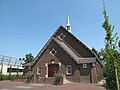 教堂
教堂 -
 教堂
教堂 -
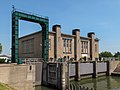 泵站
泵站


參考資料 編輯
- ^ Historie [History]. Gemeente Hardinxveld-Giessendam. [26 July 2013]. (原始內容存檔於2013-05-10) (荷蘭語).
- ^ Collegeleden [Members of the board]. Gemeente Hardinxveld-Giessendam. [26 July 2013]. (原始內容存檔於2013-05-10) (荷蘭語).
- ^ Kerncijfers wijken en buurten [地區關鍵統計數字]. 荷蘭中央統計局統計數據. 荷蘭中央統計局. 2013-07-02 [2014-03-12] (荷蘭語).
- ^ Postcodetool for 3371AL. Actueel Hoogtebestand Nederland. Het Waterschapshuis. [26 July 2013]. (原始內容存檔於2018-12-25) (荷蘭語).
- ^ Bevolkingsontwikkeling; regio per maand [Population growth; regions per month]. 荷蘭中央統計局統計數據. 荷蘭中央統計局. 1 January 2019 [2019年1月1日] (荷蘭語).
外部連結 編輯
- Official Website(頁面存檔備份,存於網際網路檔案館)
- Protest page of some citizens
- https://web.archive.org/web/20080120214647/http://www.plattegronden.nl/gemeentehardinxveld-giessendam/