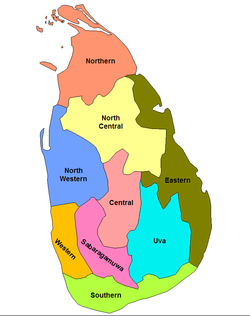
斯里蘭卡行政區劃
斯里蘭卡劃分為9個省(පලාත)和25個行政區(දිස්ත්රික්ක):

省列表 編輯
| 省份 | 所在位置 | 省會 | 建立時間 | 面積 in km2 (mi2[1] |
水域面積 in km2 (mi2)[1] |
總面積 in km2 (mi2)[1] |
人口 (2012)[2] |
人口密度 per km2 (per mi2) |
|---|---|---|---|---|---|---|---|---|
| 中央省 | 康提 | 1833年10月1日 | 5,575(2,153) | 99(38) | 5,674(2,191) | 2,571,557 | 461(1,190) | |
| 東部省 | 亭可馬里 | 1833年10月1日 | 9,361(3,614) | 635(245) | 9,996(3,859) | 1,555,510 | 166(430) | |
| 北中省 | 阿努拉德普勒 | 1873年 | 9,741(3,761) | 731(282) | 10,472(4,043) | 1,266,663 | 130(340) | |
| 北部省 | 賈夫納 | 1833年10月1日 | 8,290(3,200) | 594(229) | 8,884(3,430) | 1,061,315 | 128(330) | |
| 西北省 | 庫魯內格勒 | 1845年 | 7,506(2,898) | 382(147) | 7,888(3,046) | 2,380,861 | 317(820) | |
| 薩伯勒格穆沃省 | 拉特納普勒 | 1889年 | 4,921(1,900) | 47(18) | 4,968(1,918) | 1,928,655 | 392(1,020) | |
| 南部省 | 加勒 | 1833年10月1日 | 5,383(2,078) | 161(62) | 5,544(2,141) | 2,477,285 | 460(1,200) | |
| 烏沃省 | 巴杜勒 | 1886年 | 8,335(3,218) | 165(64) | 8,500(3,300) | 1,266,463 | 152(390) | |
| 西部省 | 科倫坡 | 1833年10月1日 | 3,593(1,387) | 91(35) | 3,684(1,422) | 5,851,130 | 1,628(4,220) | |
| 總計 | 62,705(24,211) | 2,905(1,122) | 65,610(25,330) | 20,359,439 | 325(840) |
參考資料 編輯
- ^ 1.0 1.1 1.2 Table 1.1: Area of Sri Lanka by province and district (PDF). Statistical Abstract 2014. Department of Census and Statistics, Sri Lanka. [2022-07-15]. (原始內容存檔 (PDF)於2015-11-13).
- ^ Census of Population and Housing of Sri Lanka, 2012 – Table A1: Population by district, sex and sector (PDF). Department of Census & Statistics, Sri Lanka. [2022-07-15]. (原始內容存檔 (PDF)於2014-12-28).
延伸閱讀 編輯
- Mendis, G. C. Ceylon Under the British 2nd (Revised). Colombo: Colombo Apothecaries' Company. 1946 [2018-05-18]. (原始內容存檔於2019-08-11).