File:DOCUMENTARY - LITHOGRAPHIC PROCESS (PRIVATE COLLECTION) - American Can Company, Boston and Hudson Streets, Baltimore, Independent City, MD HAER MD,4-BALT,125-59.tif

此 TIF 檔案的 JPG 預覽的大小:743 × 600 像素。 其他解析度:298 × 240 像素 | 595 × 480 像素 | 952 × 768 像素 | 1,269 × 1,024 像素 | 2,538 × 2,048 像素 | 4,889 × 3,945 像素。
原始檔案 (4,889 × 3,945 像素,檔案大小:18.4 MB,MIME 類型:image/tiff)
摘要
| DOCUMENTARY - LITHOGRAPHIC PROCESS (PRIVATE COLLECTION) - American Can Company, Boston and Hudson Streets, Baltimore, Independent City, MD | ||||
|---|---|---|---|---|
| 標題 |
DOCUMENTARY - LITHOGRAPHIC PROCESS (PRIVATE COLLECTION) - American Can Company, Boston and Hudson Streets, Baltimore, Independent City, MD |
|||
| 描述 |
Sanitary Can Company; Norton Tin Plate Company; Norton, Edwin; Shopes, Linda; Taft, Louise; Barrett, Edmund |
|||
| 描繪地點 | Maryland; Independent City; Baltimore | |||
| 日期 | Documentation compiled after 1968 | |||
| 尺寸 | 4 x 5 in. | |||
| 目前所在位置 |
Library of Congress Prints and Photographs Division Washington, D.C. 20540 USA http://hdl.loc.gov/loc.pnp/pp.print |
|||
| 登錄號 |
HAER MD,4-BALT,125-59 |
|||
| 取得方式/備註 |
|
|||
| 備註 |
|
|||
| 來源 | https://www.loc.gov/pictures/item/md1146.photos.085975p | |||
| 授權許可 (重用此檔案) |
|
|||

| 目標地點 | | 位於此地的本圖片與其他圖片: OpenStreetMap |
|---|
檔案歷史
點選日期/時間以檢視該時間的檔案版本。
| 日期/時間 | 縮圖 | 尺寸 | 使用者 | 備註 | |
|---|---|---|---|---|---|
| 目前 | 2014年7月28日 (一) 17:56 | 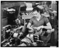 | 4,889 × 3,945(18.4 MB) | Fæ | GWToolset: Creating mediafile for Fæ. HABS 21 July 2014 (1601:1800) |
檔案用途
下列頁面有用到此檔案: