File:Typhoon Sonca 2005.jpg

預覽大小:600 × 600 像素。 其他解析度:240 × 240 像素 | 480 × 480 像素 | 768 × 768 像素 | 1,024 × 1,024 像素 | 2,048 × 2,048 像素 | 5,400 × 5,400 像素。
原始檔案 (5,400 × 5,400 像素,檔案大小:3.32 MB,MIME 類型:image/jpeg)
摘要
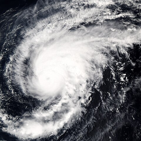
| 描述 | Typhoon Sonca was just beginning to weaken on April 25, 2005, when the Moderate Resolution Imaging Spectroradiometer (MODIS) on NASA’s Aqua satellite captured this image of the storm. Sonca is spinning across the Philippine Sea, heading towards Iwo Jima island south of Japan’s main island, Honshu. At the time this image was taken at 04:10 UTC, the storm’s winds were slowing from 213 kilometers per hour (132 mph) with gusts to 259 kph (161 mph) to 204 kph (127 mph) with gusts to 250 kph (155 mph). An eye is barely visible as a circular smudge in the center of the storm. The storm is predicted to continue to weaken. | |||||
| 日期 | ||||||
| 來源 | http://earthobservatory.nasa.gov/NaturalHazards/natural_hazards_v2.php3?img_id=12838 | |||||
| 作者 | NASA image created by Jesse Allen, Earth Observatory, using data obtained from the MODIS Rapid Response team. | |||||
| 授權許可 (重用此檔案) |
|

檔案歷史
點選日期/時間以檢視該時間的檔案版本。
| 日期/時間 | 縮圖 | 尺寸 | 使用者 | 備註 | |
|---|---|---|---|---|---|
| 目前 | 2006年9月6日 (三) 15:27 | | 5,400 × 5,400(3.32 MB) | Good kitty | == Summary == {{Information |Description=Typhoon Sonca was just beginning to weaken on April 25, 2005, when the Moderate Resolution Imaging Spectroradiometer (MODIS) on NASA’s Aqua satellite captured this image of the storm. Sonca is spinning across the |
檔案用途
下列頁面有用到此檔案:
全域檔案使用狀況
以下其他 wiki 使用了這個檔案:
- en.wikipedia.org 的使用狀況
- ja.wikipedia.org 的使用狀況