File:Map of Finland-en.svg

此SVG文件的PNG预览的大小:409 × 599像素。 其他分辨率:164 × 240像素 | 328 × 480像素 | 524 × 768像素 | 699 × 1,024像素 | 1,399 × 2,048像素 | 1,371 × 2,007像素。
原始文件 (SVG文件,尺寸为1,371 × 2,007像素,文件大小:3.57 MB)
摘要
| 描述 |
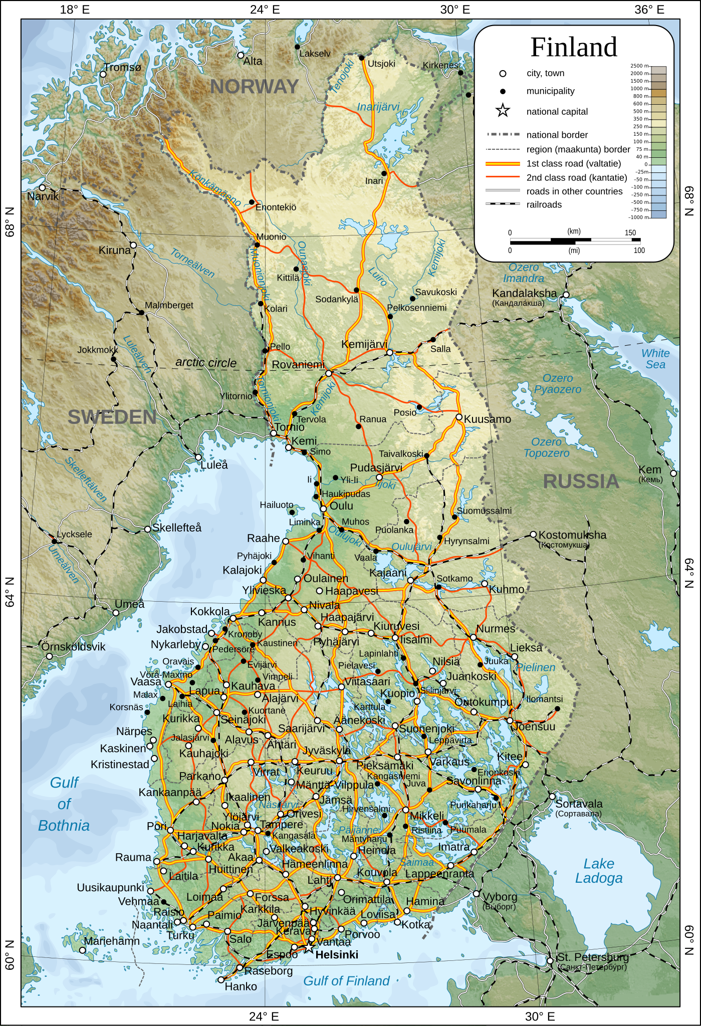
English: Map of Finland.
Suomi: Suomen kartta.
Svenska: Karta över Finland.
|
| 日期 | |
| 来源 | 自己的作品 |
| 作者 | Oona Räisänen |
| 授权 (二次使用本文件) |
See below. I've worked hard to create this map, so even though not mandatory, please attribute me wherever it is suitable. |
| 其他版本 |
[]
|
| SVG开发 | 此SVG 文件使用了内嵌文本,可以使用任何文本编辑器轻松翻译。 |


许可协议
| 我,本作品著作权人,释出本作品至公有领域。这适用于全世界。 在一些国家这可能不合法;如果是这样的话,那么: 我无条件地授予任何人以任何目的使用本作品的权利,除非这些条件是法律规定所必需的。 |
文件历史
点击某个日期/时间查看对应时刻的文件。
| 日期/时间 | 缩略图 | 大小 | 用户 | 备注 | |
|---|---|---|---|---|---|
| 当前 | 2009年12月26日 (六) 13:44 | | 1,371 × 2,007(3.57 MB) | Mysid | added some cities, municipalities, and height color legend |
| 2009年12月24日 (四) 10:18 |  | 1,371 × 2,007(3.46 MB) | Mysid | updated with topography, bathymetry, and revised provinces | |
| 2009年3月5日 (四) 00:40 |  | 1,371 × 2,007(886 KB) | Mysid | fonts | |
| 2009年3月5日 (四) 00:37 |  | 1,371 × 2,007(885 KB) | Mysid | {{Information |Description={{en|1=Map of w:Finland.}} {{fi|1=Suomen kartta.}} {{sv|1=Karta över sv:Finland.}} |Source=Self-made in Inkscape after CIA. |Author=Mysid |Date=2009-03-05 |Permission= |other_versions= |
文件用途
全域文件用途
以下其他wiki使用此文件:
- af.wikipedia.org上的用途
- ar.wikipedia.org上的用途
- avk.wikipedia.org上的用途
- be.wikipedia.org上的用途
- bg.wikipedia.org上的用途
- cs.wikipedia.org上的用途
- cy.wikipedia.org上的用途
- de.wikipedia.org上的用途
- en.wikipedia.org上的用途
- fa.wikipedia.org上的用途
- fr.wikipedia.org上的用途
- he.wikipedia.org上的用途
- hr.wiktionary.org上的用途
- hy.wikipedia.org上的用途
- io.wikipedia.org上的用途
- ja.wikipedia.org上的用途
- ka.wikipedia.org上的用途
- mk.wikipedia.org上的用途
- nl.wikipedia.org上的用途
- pl.wikipedia.org上的用途
- pl.wiktionary.org上的用途
- pnb.wikipedia.org上的用途
- rm.wikipedia.org上的用途
- ro.wikipedia.org上的用途
- ru.wikipedia.org上的用途
- sco.wikipedia.org上的用途
- simple.wikipedia.org上的用途
- sr.wikipedia.org上的用途
- tr.wikipedia.org上的用途
- uk.wikipedia.org上的用途