File:Karte Metropolregion Berlin-Brandenburg.svg

此SVG文件的PNG预览的大小:597 × 600像素。 其他分辨率:239 × 240像素 | 478 × 480像素 | 764 × 768像素 | 1,019 × 1,024像素 | 2,038 × 2,048像素 | 829 × 833像素。
原始文件 (SVG文件,尺寸为829 × 833像素,文件大小:327 KB)
摘要
| 描述 |
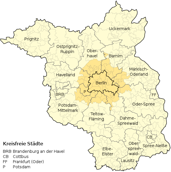
Deutsch: Metropolregion Berlin-Brandenburg (in hellgelb), engerer Metropolenraum/Kernraum (Agglomeration bzw. „Speckgürtel“ in dunkelgelb |
| 日期 | (UTC) |
| 来源 | |
| 作者 |
|
许可协议
本文件采用知识共享署名-相同方式共享 3.0 未本地化版本许可协议授权。
- 您可以自由地:
- 共享 – 复制、发行并传播本作品
- 修改 – 改编作品
- 惟须遵守下列条件:
- 署名 – 您必须对作品进行署名,提供授权条款的链接,并说明是否对原始内容进行了更改。您可以用任何合理的方式来署名,但不得以任何方式表明许可人认可您或您的使用。
- 相同方式共享 – 如果您再混合、转换或者基于本作品进行创作,您必须以与原先许可协议相同或相兼容的许可协议分发您贡献的作品。
原始上传日志
This image is a derivative work of the following images:
- File:Metropolregion-BerlinBrandenburg-Infrastruktur.svg licensed with Cc-by-sa-3.0,2.5,2.0,1.0, GFDL
- 2010-04-05T18:46:25Z Broadway 825x826 (913709 Bytes) Hintergrund
- 2010-04-05T17:38:41Z Broadway 825x826 (976010 Bytes) {{Information |Description={{de|1=Infrastruktur der Metropolregion Berlin-Brndenburg}} {{en|1=Infrastructure of Berlin-Brandenburg, Germany}} |Source=self-made, using [[:Image:Landkreise Brandenburg.svg|Landkreise Brandenburg
文件历史
点击某个日期/时间查看对应时刻的文件。
| 日期/时间 | 缩略图 | 大小 | 用户 | 备注 | |
|---|---|---|---|---|---|
| 当前 | 2020年11月15日 (日) 22:55 | | 829 × 833(327 KB) | Dingens5 | Kfz-Kennzeichen statt Zahl für kreisfreie Städte |
| 2013年2月27日 (三) 18:21 |  | 829 × 833(322 KB) | NordNordWest | c | |
| 2012年12月16日 (日) 13:19 |  | 829 × 833(495 KB) | NordNordWest | == {{int:filedesc}} == {{Information |Description={{de|1=Metropolregion Berlin-Brandenburg (in hellgelb), engerer Metropolenraum/Kernraum in dunkelgelb}} |Source={{Derived from|Metropolregion-BerlinBrandenburg-Infrastruktur.svg}} * http://gl.berlin-bra... |
文件用途
以下页面使用本文件:
全域文件用途
以下其他wiki使用此文件:
- de.wikipedia.org上的用途
- Hauptstadtregion Berlin-Brandenburg
- Liste der Hallenkirchen in Deutschland
- Agglomeration Berlin
- Wikipedia:Kartenwerkstatt/Archiv/2012-12
- Wikipedia:Auskunft/Archiv/2017/Woche 30
- Geografie Berlins
- Liste der Bauwerke der norddeutschen und rheinischen Backsteingotik in Deutschland
- Benutzer:Ulamm/Positionskartenlimit
- Benutzer:Z thomas/BB-0
- diq.wikipedia.org上的用途
- es.wikipedia.org上的用途
- frr.wikipedia.org上的用途
- fr.wikipedia.org上的用途
- it.wikipedia.org上的用途
- www.wikidata.org上的用途