File:TS Quedan 2005.jpg

預覽大小:464 × 599 像素。 其他解析度:186 × 240 像素 | 372 × 480 像素 | 595 × 768 像素 | 793 × 1,024 像素 | 1,586 × 2,048 像素 | 3,904 × 5,041 像素。
原始檔案 (3,904 × 5,041 像素,檔案大小:1.96 MB,MIME 類型:image/jpeg)
摘要
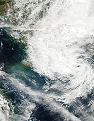
| 描述 | This image of Tropical Storm 25W (also called Quedan by PAGASA) was captured at 0641 UTC on December 20, 2005 by the MODIS instrument on NASA's Aqua satellite. At the time it was located west of the Philippines with maximum sustained winds of 25 knots and a minimum pressure of approximately 1006 mb. | ||||||
| 日期 | |||||||
| 來源 | http://www.nrlmry.navy.mil/tc_pages/tc_home.html | ||||||
| 作者 | Naval Research Laboratory | ||||||
| 授權許可 (重用此檔案) |
|
||||||

檔案歷史
點選日期/時間以檢視該時間的檔案版本。
| 日期/時間 | 縮圖 | 尺寸 | 使用者 | 備註 | |
|---|---|---|---|---|---|
| 目前 | 2018年1月15日 (一) 03:41 | | 3,904 × 5,041(1.96 MB) | Nino Marakot | True color, grid-less and larger coverage |
| 2006年9月14日 (四) 04:47 |  | 2,928 × 3,444(1.33 MB) | Good kitty | == Summary == {{Information |Description=This image of Tropical Storm 25W (also called Quedan by PAGASA) was captured at 0641 UTC on December 20, 2005 by the MODIS instrument on NASA's Aqua satellite. At the time it was located west of the Philippines wit |
檔案用途
下列頁面有用到此檔案:
全域檔案使用狀況
以下其他 wiki 使用了這個檔案:
- en.wikipedia.org 的使用狀況
- es.wikipedia.org 的使用狀況
- pt.wikipedia.org 的使用狀況
- vi.wikipedia.org 的使用狀況