File:Porter1796WesternReserve-300.jpg

預覽大小:800 × 534 像素。 其他解析度:320 × 213 像素 | 640 × 427 像素 | 1,024 × 683 像素 | 1,280 × 854 像素 | 2,560 × 1,707 像素 | 7,403 × 4,937 像素。
原始檔案 (7,403 × 4,937 像素,檔案大小:6.67 MB,MIME 類型:image/jpeg)
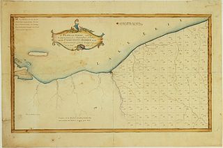
| 描述 | A Plan of the Survey made by & under the direction of Augustus Porter upon the Connecticut-Reserve for the Connecticut Land Company in the Year 1796. Showing the Western Reserve divided into sections and the town and city of Cleaveland (Cleveland) |
| 日期 | |
| 來源 | William L. Clements Library (University of Michigan) |
| 作者 | Augustus Porter |
| 其他版本 | http://www.railsandtrails.com/Maps/Porter1796WesternReserve/index.htm |
|
本作品在其來源國以及其他著作權期限是作者逝世後100年或以下的國家與地區屬於公有領域。 | |
| 此作品無已知的著作權限制,亦不受所有相關和鄰接的權利限制。 | |
檔案歷史
點選日期/時間以檢視該時間的檔案版本。
| 日期/時間 | 縮圖 | 尺寸 | 使用者 | 備註 | |
|---|---|---|---|---|---|
| 目前 | 2010年10月13日 (三) 23:43 | | 7,403 × 4,937(6.67 MB) | Scewing | {{Information |Description=A Plan of the Survey made by & under the direction of Augustus Porter upon the Connecticut-Reserve for the Connecticut Land Company in the Year 1796. Showing the Western Reserve divided into sections and the town and city of Cle |
檔案用途
下列頁面有用到此檔案:
全域檔案使用狀況
以下其他 wiki 使用了這個檔案:
- en.wikipedia.org 的使用狀況
- ja.wikipedia.org 的使用狀況