File:Map of Constantinople (1422) by Florentine cartographer Cristoforo Buondelmonte.jpg
預覽大小:476 × 600 像素。 其他解析度:190 × 240 像素 | 592 × 746 像素。
原始檔案 (592 × 746 像素,檔案大小:838 KB,MIME 類型:image/jpeg)
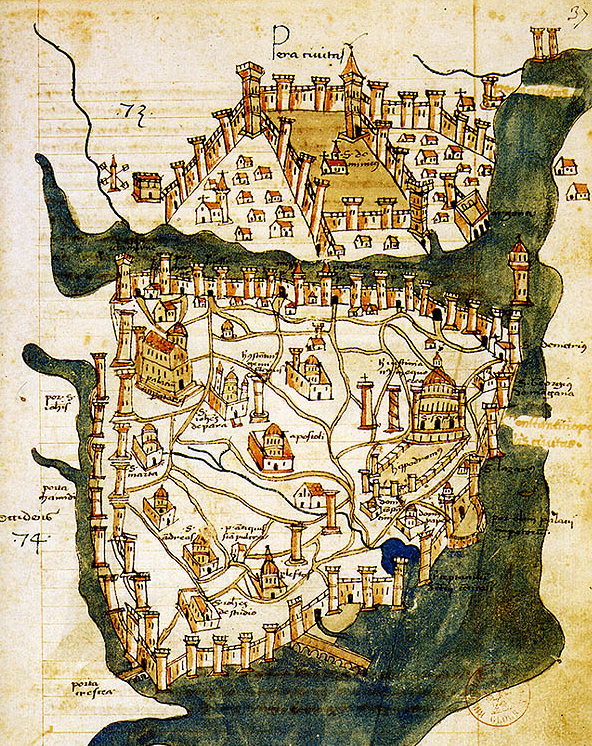
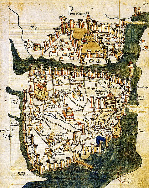
| 描述 | Map of Constantinople (a small part of modern Istanbul), called "Historic Peninsula", Tarihi Yarımada en Turkish) designed in 1422 by Florentine cartographer Cristoforo Buondelmonti (Description des îles de l'archipel, Bibliothèque nationale, Paris) is the oldest surviving map of the city, and the only surviving map which predates the Turkish conquest of Constantinople in 1453. | ||||
| 日期 | |||||
| 來源 | Liber insularum Archipelagi (1824), version available at the Bibliothèque nationale de France, Paris | ||||
| 作者 | Cristoforo Buondelmonti | ||||
| 授權許可 (重用此檔案) |
|
||||
| 其他版本 |
|
||||

_by_Florentine_cartographer_Cristoforo_Buondelmonte.jpg?uselang=zh-tw)
_by_Florentine_cartographer_Cristoforo_Buondelmonte.jpg?uselang=zh-tw)
_by_Florentine_cartographer_Cristoforo_Buondelmonte.jpg?action=history&uselang=zh-tw)
_by_Florentine_cartographer_Cristoforo_Buondelmonte.jpg)
檔案歷史
點選日期/時間以檢視該時間的檔案版本。
| 日期/時間 | 縮圖 | 尺寸 | 使用者 | 備註 | |
|---|---|---|---|---|---|
| 目前 | 2007年6月25日 (一) 10:24 | | 592 × 746(838 KB) | M.K. | {{Information |Description=Map of Constantinople (1422) by Florentine cartographer Cristoforo Buondelmonte (''Description des îles de l'archipel'', Bibliothèque nationale, Paris) is the oldest surviving map of the city, and the only surviving ma |
檔案用途
下列6個頁面有用到此檔案:
全域檔案使用狀況
以下其他 wiki 使用了這個檔案:
- ar.wikipedia.org 的使用狀況
- az.wikipedia.org 的使用狀況
- ba.wikipedia.org 的使用狀況
- bg.wikipedia.org 的使用狀況
- ca.wikipedia.org 的使用狀況
- ce.wikipedia.org 的使用狀況
- cs.wikipedia.org 的使用狀況
- de.wikipedia.org 的使用狀況
- el.wikipedia.org 的使用狀況
- en.wikipedia.org 的使用狀況
- Bosporus
- Constantinople
- Constantine XI Palaiologos
- John VII Palaiologos
- Walls of Constantinople
- Beyoğlu
- Maiden's Tower
- Siege of Constantinople (1422)
- Siege of Constantinople (1411)
- Template:Did you know nominations/Kontoskalion
- Piyalepaşa, Beyoğlu
- Wikipedia:Main Page history/2019 February 23
- Siege of Constantinople (1394–1402)
- es.wikipedia.org 的使用狀況
- et.wikipedia.org 的使用狀況
- eu.wikipedia.org 的使用狀況
- fa.wikipedia.org 的使用狀況
- frp.wikipedia.org 的使用狀況
- fr.wikipedia.org 的使用狀況
檢視此檔案的更多全域使用狀況。
_by_Florentine_cartographer_Cristoforo_Buondelmonte.jpg)
_by_Florentine_cartographer_Cristoforo_Buondelmonte.jpg)