File:KT boundary 054.jpg

預覽大小:800 × 600 像素。 其他解析度:320 × 240 像素 | 640 × 480 像素 | 1,024 × 768 像素 | 1,280 × 960 像素 | 1,600 × 1,200 像素。
原始檔案 (1,600 × 1,200 像素,檔案大小:860 KB,MIME 類型:image/jpeg)
摘要
| 描述 |
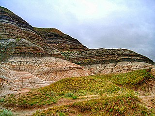
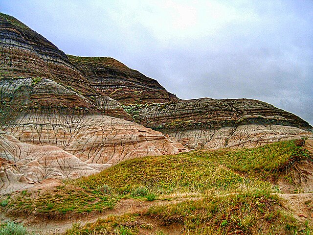
English: Badlands near Drumheller, Alberta, where erosion has exposed the K-Pg boundary. |
| 日期 | 2005年8月12日 (原始上傳日期) |
| 來源 | photo G Larson; Transferred from en.wikipedia |
| 作者 | Original uploader was Glenlarson at en.wikipedia |
| 授權許可 (重用此檔案) |
PD-User |
授權條款
| |
此作品已由其作者,中文維基百科專案的Glenlarson,釋出至公有領域。此授權條款在全世界均適用。 如果法律不適用時: |
原始上傳日誌
The original description page was here. All following user names refer to en.wikipedia.
- 2005-08-12 20:57 Glenlarson 1600×1200×8 (769372 bytes) KT boundary photo G Larson {{pd}}
檔案歷史
點選日期/時間以檢視該時間的檔案版本。
| 日期/時間 | 縮圖 | 尺寸 | 使用者 | 備註 | |
|---|---|---|---|---|---|
| 目前 | 2022年4月12日 (二) 12:23 | | 1,600 × 1,200(860 KB) | J. N. Squire | Colors, contrast and saturation adjusted |
| 2008年1月19日 (六) 18:18 |  | 1,600 × 1,200(751 KB) | EuTuga | {{Information |Description={{en|Badlands near Drumheller, Alberta, where erosion has exposed the KT boundary.}} |Source=photo G Larson; Transferred from [http://en.wikipedia.org en.wikipedia] |Date=2005-08-12 (original upload date) |
檔案用途
下列頁面有用到此檔案:
全域檔案使用狀況
以下其他 wiki 使用了這個檔案:
- af.wikipedia.org 的使用狀況
- ar.wikipedia.org 的使用狀況
- bs.wikipedia.org 的使用狀況
- ca.wikipedia.org 的使用狀況
- cs.wikipedia.org 的使用狀況
- da.wikipedia.org 的使用狀況
- de.wikipedia.org 的使用狀況
- el.wikipedia.org 的使用狀況
- en.wikipedia.org 的使用狀況
- en.wikibooks.org 的使用狀況
- en.wikiversity.org 的使用狀況
- eo.wikipedia.org 的使用狀況
- es.wikipedia.org 的使用狀況
- fa.wikipedia.org 的使用狀況
- fr.wikipedia.org 的使用狀況
- gl.wikipedia.org 的使用狀況
- he.wikipedia.org 的使用狀況
- hu.wikipedia.org 的使用狀況
- id.wikipedia.org 的使用狀況
- it.wikipedia.org 的使用狀況
- ja.wikipedia.org 的使用狀況
- kw.wikipedia.org 的使用狀況
- la.wikipedia.org 的使用狀況
- mk.wikipedia.org 的使用狀況
- ml.wikipedia.org 的使用狀況
- ms.wikipedia.org 的使用狀況
- nn.wikipedia.org 的使用狀況
- no.wikipedia.org 的使用狀況
- oc.wikipedia.org 的使用狀況
- pl.wikipedia.org 的使用狀況
- pt.wikipedia.org 的使用狀況
- ro.wikipedia.org 的使用狀況
- ru.wikipedia.org 的使用狀況
檢視此檔案的更多全域使用狀況。