File:Comparison azimuthal projections.svg

此 SVG 檔案的 PNG 預覽的大小:512 × 171 像素。 其他解析度:320 × 107 像素 | 640 × 214 像素 | 1,024 × 342 像素 | 1,280 × 428 像素 | 2,560 × 855 像素。
原始檔案 (SVG 檔案,表面大小:512 × 171 像素,檔案大小:113 KB)
摘要
| 描述 |
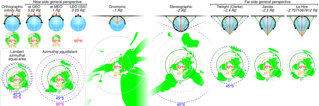
English: Comparison of some azimuthal projections of the world map based on information on http://www.progonos.com/furuti/MapProj/Normal/ProjAz/projAz.html . Values indicated are mean altitudes in terms of Earth radii. Circles denote latitudes of multiples of 15-degrees (dashed lines represent the southern hemisphere). In the SVG file, hover over a circle to show its latitude in a tooltip. |
| 來源 | 自己的作品 |
| 作者 | Cmglee |
| SVG開發 | 本vector image使用Python創作。 |
授權條款
我,本作品的著作權持有者,決定用以下授權條款發佈本作品:
此檔案採用創用CC 姓名標示-相同方式分享 3.0 未在地化版本授權條款。
- 您可以自由:
- 分享 – 複製、發佈和傳播本作品
- 重新修改 – 創作演繹作品
- 惟需遵照下列條件:
- 姓名標示 – 您必須指名出正確的製作者,和提供授權條款的連結,以及表示是否有對內容上做出變更。您可以用任何合理的方式來行動,但不得以任何方式表明授權條款是對您許可或是由您所使用。
- 相同方式分享 – 如果您利用本素材進行再混合、轉換或創作,您必須基於如同原先的相同或兼容的條款,來分布您的貢獻成品。

|
已授權您依據自由軟體基金會發行的無固定段落、封面文字和封底文字GNU自由文件授權條款1.2版或任意後續版本,對本檔進行複製、傳播和/或修改。該協議的副本列在GNU自由文件授權條款中。 |
您可以選擇您需要的授權條款。
檔案歷史
點選日期/時間以檢視該時間的檔案版本。
| 日期/時間 | 縮圖 | 尺寸 | 使用者 | 備註 | |
|---|---|---|---|---|---|
| 目前 | 2019年6月3日 (一) 00:42 | 512 × 171(113 KB) | Cmglee | Put a box around equal-area and equidistant projections. | |
| 2017年11月6日 (一) 09:09 | 512 × 171(113 KB) | Cmglee | Use <?xml version="1.0" encoding="utf-8"?> instead of <!DOCTYPE svg PUBLIC "-//W3C//DTD SVG 1.1//EN" "http://www.w3.org/Graphics/SVG/1.1/DTD/svg11.dtd"> . | ||
| 2017年11月5日 (日) 09:42 | 512 × 171(113 KB) | Cmglee | Change primary font to Helvetica and restore minus signs as thumbnail generation is broken (degrees appear as "?"). | ||
| 2017年11月5日 (日) 09:40 | 512 × 171(113 KB) | Cmglee | Use plain "-" as en dashes don't appear in thumbnail. | ||
| 2017年11月5日 (日) 09:37 | 512 × 171(113 KB) | Cmglee | Replace minus signs with en dashes as they don't appear in thumbnails. | ||
| 2017年11月5日 (日) 09:32 | 512 × 171(113 KB) | Cmglee | Add map and tooltips. | ||
| 2015年2月27日 (五) 01:25 | 512 × 171(56 KB) | Cmglee | Fix azimuthal equidistant scale and tweak globe and labels. | ||
| 2015年2月25日 (三) 01:06 | 512 × 171(52 KB) | Cmglee | Further increase font size. | ||
| 2015年2月25日 (三) 00:17 | 512 × 171(52 KB) | Cmglee | Fix font size and line width. | ||
| 2015年2月25日 (三) 00:15 | 512 × 171(52 KB) | Cmglee | {{Information |Description ={{en|1=Comparison of some azimuthal projections of the world map based on information on http://www.progonos.com/furuti/MapProj/Normal/ProjAz/projAz.html . Values indicated are mean altitudes in terms of Earth radii. Circ... |
檔案用途
下列頁面有用到此檔案:
全域檔案使用狀況
以下其他 wiki 使用了這個檔案:
- de.wikipedia.org 的使用狀況
- en.wikipedia.org 的使用狀況
- es.wikipedia.org 的使用狀況
- fi.wikipedia.org 的使用狀況
- ja.wikipedia.org 的使用狀況