File:Claudette 2015 track.png
預覽大小:800 × 495 像素。 其他解析度:320 × 198 像素 | 640 × 396 像素 | 1,024 × 633 像素 | 1,280 × 791 像素 | 2,700 × 1,669 像素。
原始檔案 (2,700 × 1,669 像素,檔案大小:2.74 MB,MIME 類型:image/png)
摘要
| 描述 |
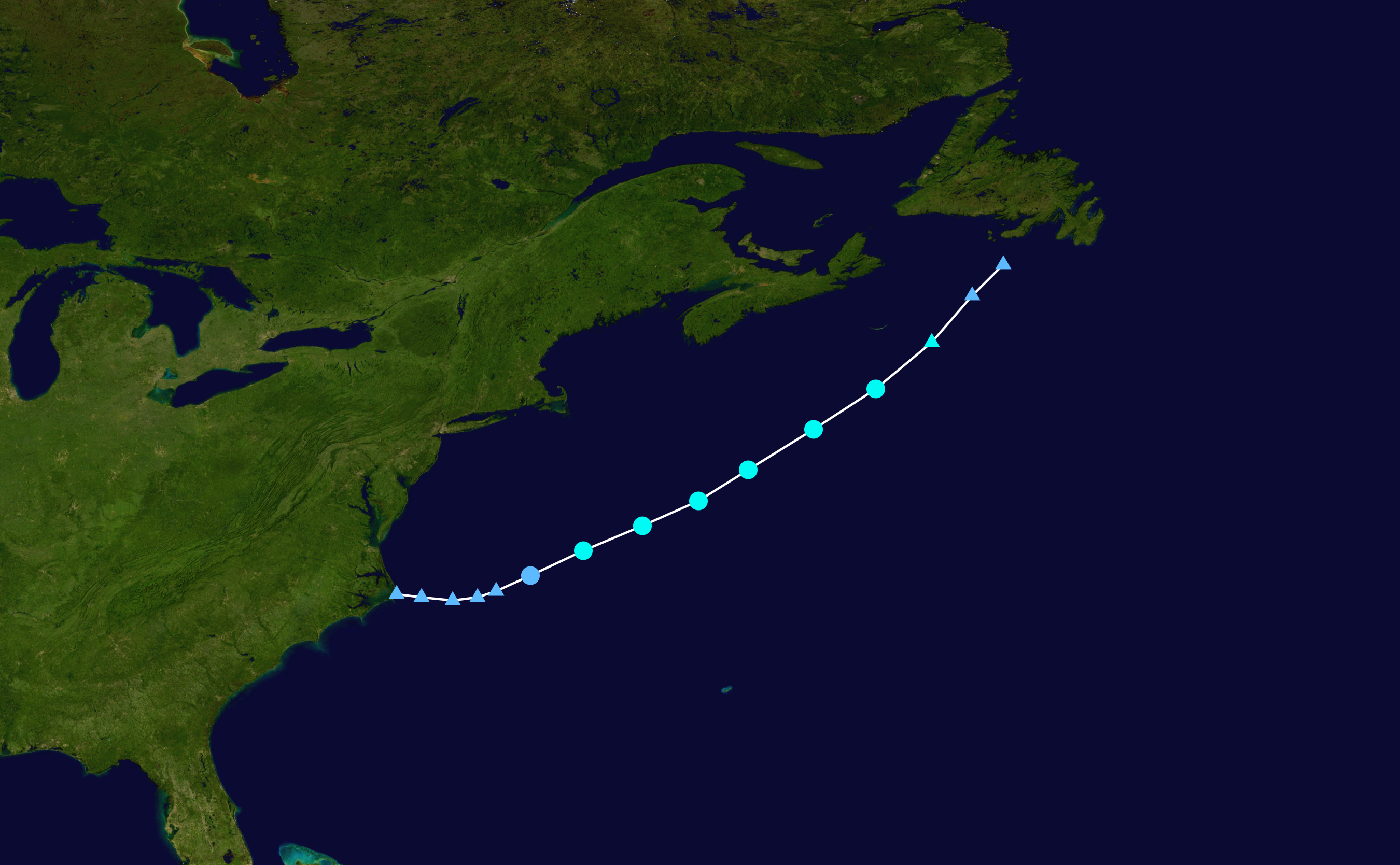
English: Track map of Tropical Storm Claudette of the 2015 Atlantic hurricane season. The points show the location of the storm at 6-hour intervals. The colour represents the storm's maximum sustained wind speeds as classified in the (see below), and the shape of the data points represent the nature of the storm, according to the legend below. Tropical depression (≤38 mph, ≤62 km/h)
Tropical storm (39–73 mph, 63–118 km/h)
Category 1 (74–95 mph, 119–153 km/h)
Category 2 (96–110 mph, 154–177 km/h)
Category 3 (111–129 mph, 178–208 km/h)
Category 4 (130–156 mph, 209–251 km/h)
Category 5 (≥157 mph, ≥252 km/h)
Unknown
Storm type |
||
| 日期 | 2015-07-12–2015-07-14 | ||
| 來源 | Created by Cyclonebiskit using Wikipedia:WikiProject Tropical cyclones/Tracks. The background image is from NASA. Tracking data is from the National Hurricane Center[1]. | ||
| 作者 | Cyclonebiskit | ||
| Source code | Track map data table, if present below, is in HURDAT2 or ATCF format. See format details in [2] and [3], respectively.
|
授權條款
| 此作品已由其作者,Cyclonebiskit,釋出至公有領域。此授權條款在全世界均適用。 這可能在某些國家不合法,如果是的話: Cyclonebiskit授予任何人有權利使用此作品於任何用途,除受法律約束外,不受任何限制。 |
檔案歷史
點選日期/時間以檢視該時間的檔案版本。
| 日期/時間 | 縮圖 | 尺寸 | 使用者 | 備註 | |
|---|---|---|---|---|---|
| 目前 | 2015年8月18日 (二) 19:57 | | 2,700 × 1,669(2.74 MB) | Supportstorm | Added missing point |
| 2015年8月17日 (一) 17:08 |  | 2,700 × 1,669(2.69 MB) | Supportstorm | Best track | |
| 2015年7月21日 (二) 05:08 |  | 2,000 × 1,236(2.03 MB) | Cyclonebiskit | It's the same issue as Ana, the OPC will follow systems as lows even if they're not closed (NHC discontinues tracks when lows open up). This is to avoid misleading information when there are uncertainties. | |
| 2015年7月20日 (一) 22:01 |  | 2,700 × 1,764(3.38 MB) | Supportstorm | rv:OPC is the WMO metarea for this area and has higher jurisdiction over the CHC. OPC explicitly stated this low was EX-Claudette. | |
| 2015年7月20日 (一) 06:52 |  | 2,000 × 1,236(2.03 MB) | Cyclonebiskit | Canadian Hurricane Center is very clear about the center all but dissipating...I don't feel comfortable using OPC points (which do include non-closed lows) when accounting for the CHC's analysis. | |
| 2015年7月19日 (日) 21:31 |  | 2,700 × 1,764(3.38 MB) | Supportstorm | Final operational update | |
| 2015年7月18日 (六) 16:37 |  | 2,700 × 1,764(3.38 MB) | Supportstorm | 07/18 12Z update | |
| 2015年7月16日 (四) 22:06 |  | 2,700 × 1,669(2.96 MB) | Supportstorm | 07/16 18Z OPC data | |
| 2015年7月15日 (三) 23:25 |  | 2,000 × 1,236(2.03 MB) | Cyclonebiskit | Final position from the CHC | |
| 2015年7月15日 (三) 03:13 |  | 2,000 × 1,236(1.98 MB) | Cyclonebiskit | {{WPTC track map | author = Cyclonebiskit | name = Tropical Storm Claudette | article = Tropical Storm Claudette (2015) | season = 2015 Atlantic hurricane season | start = 2015-07-11 | end = 2015-07-15 | othersource=[ftp://ftp.emc.ncep.noaa.gov/... |
檔案用途
下列頁面有用到此檔案:
全域檔案使用狀況
以下其他 wiki 使用了這個檔案:
- de.wikipedia.org 的使用狀況
- es.wikipedia.org 的使用狀況
- fr.wikipedia.org 的使用狀況
- ko.wikipedia.org 的使用狀況
- pt.wikipedia.org 的使用狀況
- th.wikipedia.org 的使用狀況