File:400 through Parry Sound.png

預覽大小:800 × 600 像素。 其他解析度:320 × 240 像素 | 640 × 480 像素 | 1,024 × 768 像素 | 1,280 × 960 像素 | 2,560 × 1,920 像素 | 3,264 × 2,448 像素。
原始檔案 (3,264 × 2,448 像素,檔案大小:22.9 MB,MIME 類型:image/png)
摘要
| 描述 |
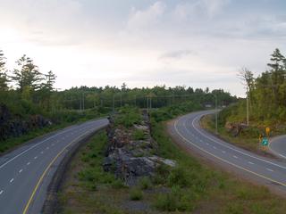
English: Highway 400 facing north from within Parry Sound. This 10 km section of Highway 400 south of and through Parry Sound features interesting and massive rock cuts, some longer than a kilometre in length and several storeys high. This section also features several median rock walls that were left in place during blasting, as in this photo. |
| 日期 |
|
| 來源 |
自己的作品
|
| 作者 | Uploaded by Floydian at en.wikipedia |
| 拍攝地點 | | 位於此地的本圖片與其他圖片: OpenStreetMap |
|---|
授權條款
此檔案採用創用CC 姓名標示-相同方式分享 3.0 未在地化版本授權條款。
- 您可以自由:
- 分享 – 複製、發佈和傳播本作品
- 重新修改 – 創作演繹作品
- 惟需遵照下列條件:
- 姓名標示 – 您必須指名出正確的製作者,和提供授權條款的連結,以及表示是否有對內容上做出變更。您可以用任何合理的方式來行動,但不得以任何方式表明授權條款是對您許可或是由您所使用。
- 相同方式分享 – 如果您利用本素材進行再混合、轉換或創作,您必須基於如同原先的相同或兼容的條款,來分布您的貢獻成品。
原始上傳日誌
The original description page was here. All following user names refer to en.wikipedia.
Upload date | User | Bytes | Dimensions | Comment
- 2011-08-26 20:44 (UTC) | Floydian | 24012115 (bytes) | 3264×2448 | {{Information |Description=Highway 400 facing north from within Parry Sound. This 10 km section of Highway 400 south of and through Parry Sound features interesting and massive rock cuts, some longer than a kilometre in length and several storeys hig
檔案歷史
點選日期/時間以檢視該時間的檔案版本。
| 日期/時間 | 縮圖 | 尺寸 | 使用者 | 備註 | |
|---|---|---|---|---|---|
| 目前 | 2011年12月12日 (一) 09:32 | | 3,264 × 2,448(22.9 MB) | SreeBot | (Original text) : {{Information |Description=Highway 400 facing north from within Parry Sound. This 10 km section of Highway 400 south of and through Parry Sound features interesting and massive rock cuts, some longer than a kilometre in length and sever |
檔案用途
下列頁面有用到此檔案:
全域檔案使用狀況
以下其他 wiki 使用了這個檔案:
- de.wikipedia.org 的使用狀況
- en.wikipedia.org 的使用狀況
- uk.wikipedia.org 的使用狀況
- www.wikidata.org 的使用狀況