File:2016 Freedom House world map.png
預覽大小:800 × 405 像素。 其他解析度:320 × 162 像素 | 640 × 324 像素 | 1,024 × 518 像素 | 1,280 × 648 像素 | 2,560 × 1,296 像素 | 4,972 × 2,517 像素。
原始檔案 (4,972 × 2,517 像素,檔案大小:361 KB,MIME 類型:image/png)
摘要
| 描述 |
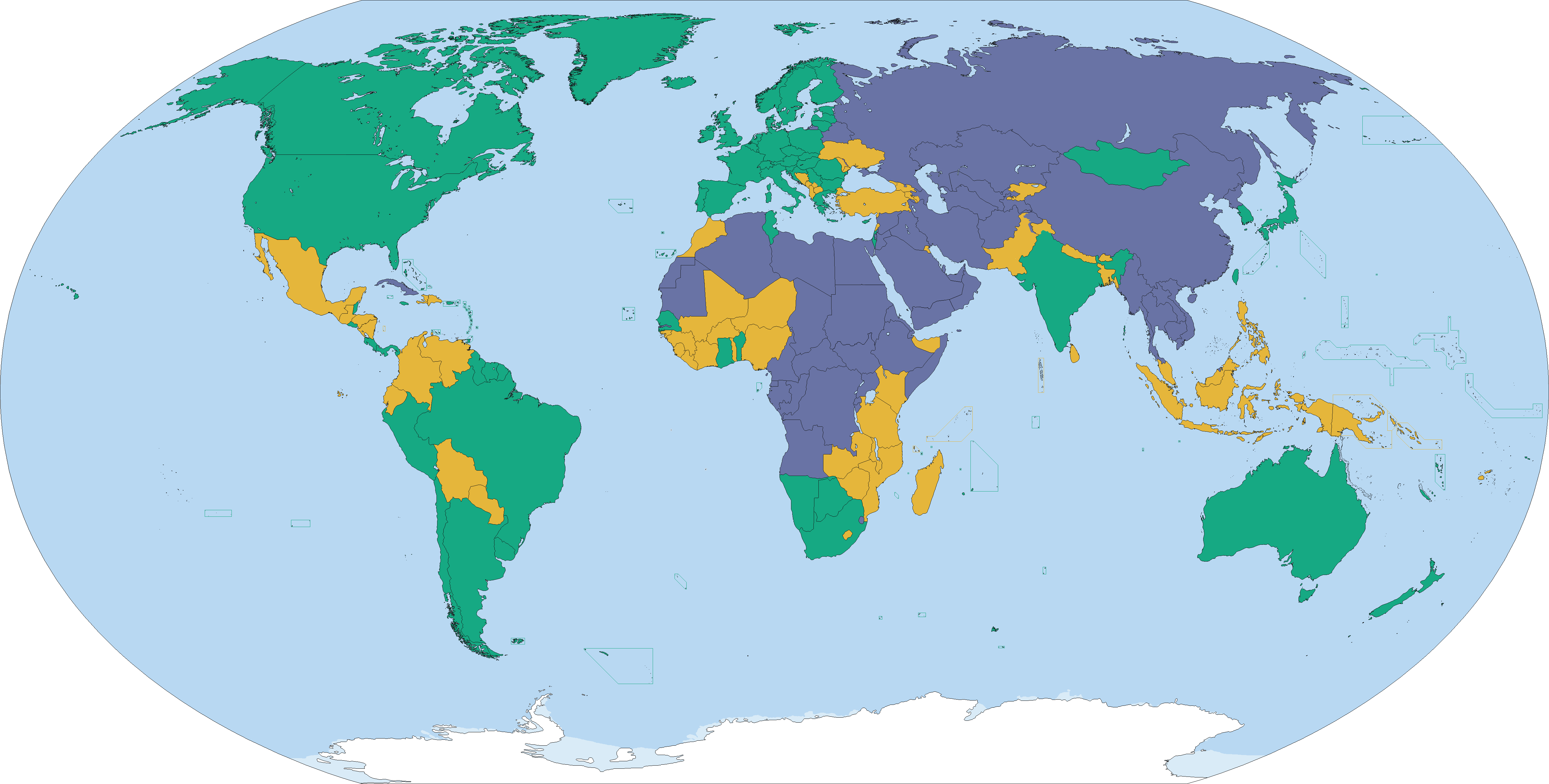
English: Country ratings from Freedom House's Freedom in the World 2016 survey, concerning the state of world freedom in 2015.[1]
Free (86) Partly Free (59) Not Free (50) See also: File:2015 Freedom House world map.png, File:2013_Freedom_House_world_map.svg |
| 日期 | |
| 來源 | 自己的作品 |
| 作者 | Abrahamic Faiths |
授權條款
我,本作品的著作權持有者,決定用以下授權條款發佈本作品:
此檔案採用創用CC 姓名標示-相同方式分享 4.0 國際授權條款。
- 您可以自由:
- 分享 – 複製、發佈和傳播本作品
- 重新修改 – 創作演繹作品
- 惟需遵照下列條件:
- 姓名標示 – 您必須指名出正確的製作者,和提供授權條款的連結,以及表示是否有對內容上做出變更。您可以用任何合理的方式來行動,但不得以任何方式表明授權條款是對您許可或是由您所使用。
- 相同方式分享 – 如果您利用本素材進行再混合、轉換或創作,您必須基於如同原先的相同或兼容的條款,來分布您的貢獻成品。
- ↑ https://freedomhouse.org/sites/default/files/FH_FITW_Report_2016.pdf Freedom in the World 2016], Freedom House. Retrieved 28 January 2016.
檔案歷史
點選日期/時間以檢視該時間的檔案版本。
| 日期/時間 | 縮圖 | 尺寸 | 使用者 | 備註 | |
|---|---|---|---|---|---|
| 目前 | 2016年5月4日 (三) 18:25 | | 4,972 × 2,517(361 KB) | VulpesVulpes42 | Fixed some island borders. |
| 2016年4月20日 (三) 18:42 |  | 4,972 × 2,517(361 KB) | VulpesVulpes42 | Fixed three pixels in Somaliland that were brighter for no reason, as well as an area in Ethiopia that was darker for no reason. | |
| 2016年4月9日 (六) 18:39 |  | 4,972 × 2,517(361 KB) | VulpesVulpes42 | Isn't it weird how doing the exact same thing using gimp doesn't double the file size? | |
| 2016年4月9日 (六) 18:14 |  | 4,972 × 2,517(361 KB) | VulpesVulpes42 | Reverted to version as of 10:02, 3 April 2016 (UTC) For some reason this file was much larger than the previous version. I expected it to become smaller. Maybe because I used paint. Lesson learned, always use gimp. | |
| 2016年4月9日 (六) 18:12 |  | 4,972 × 2,517(622 KB) | VulpesVulpes42 | Fixed an area where the shade of green was darker and the shade of yellow lighter for no apparent reason. | |
| 2016年4月3日 (日) 10:02 |  | 4,972 × 2,517(361 KB) | VulpesVulpes42 | Removed Tibet from the map. First off, why should this map show only Tibet but not the other autonomous regions? They have the same political status within the PRC. Secondly, as far as my understanding goes, this map should only show sovereign states,... | |
| 2016年3月27日 (日) 16:56 |  | 4,972 × 2,517(382 KB) | Christian Ferrer | Reverted to version as of 08:54, 26 March 2016 (UTC) | |
| 2016年3月27日 (日) 15:33 |  | 4,972 × 2,517(399 KB) | Insidema | Reverted to version as of 16:52, 25 March 2016 (UTC) | |
| 2016年3月26日 (六) 08:54 |  | 4,972 × 2,517(382 KB) | Ankry | Reverted to version as of 16:39, 28 January 2016 (UTC) | |
| 2016年3月25日 (五) 16:52 |  | 4,972 × 2,517(399 KB) | Hpyounes | Somaliland is not a sovereign State |
檔案用途
下列頁面有用到此檔案:
全域檔案使用狀況
以下其他 wiki 使用了這個檔案:
- ar.wikipedia.org 的使用狀況
- be-tarask.wikipedia.org 的使用狀況
- bg.wikipedia.org 的使用狀況
- ca.wikipedia.org 的使用狀況
- de.wikipedia.org 的使用狀況
- en.wikipedia.org 的使用狀況
- fa.wikipedia.org 的使用狀況
- fr.wikipedia.org 的使用狀況
- gn.wikipedia.org 的使用狀況
- gu.wikipedia.org 的使用狀況
- hy.wikipedia.org 的使用狀況
- id.wikipedia.org 的使用狀況
- it.wikipedia.org 的使用狀況
- ja.wikipedia.org 的使用狀況
- ko.wikipedia.org 的使用狀況
- pt.wikipedia.org 的使用狀況
- ru.wikipedia.org 的使用狀況
- simple.wikipedia.org 的使用狀況
- th.wikipedia.org 的使用狀況
- uk.wikipedia.org 的使用狀況