File:Concord Expedition and Patriot Messengers.jpg

本预览的尺寸:800 × 341像素。 其他分辨率:320 × 136像素 | 1,000 × 426像素。
原始文件 (1,000 × 426像素,文件大小:139 KB,MIME类型:image/jpeg)

|
本文件已被Concord Expedition and Patriot Messengers-en.svg取代。建议您使用其他文件。请注意,删除被取代的图片需要达成一致。
|

|
File:Concord Expedition and Patriot Messengers-en.svg是此文件的矢量版本。 如果此文件质量不低于原点阵图,就应该将这个JPG格式文件替换为此文件。
File:Concord Expedition and Patriot Messengers.jpg → File:Concord Expedition and Patriot Messengers-en.svg
更多信息请参阅Help:SVG/zh。 |
 |
摘要
| 标题 |
英语:
Routes of the British Expedition and the Patriot Messengers |
| 描写 |
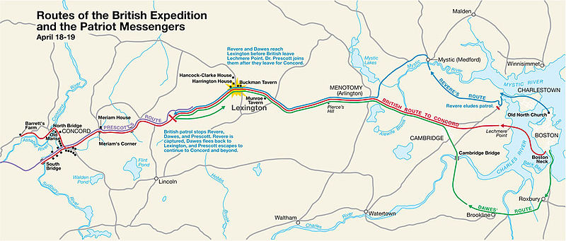
Paul Revere's Midnight Ride English: This is a map depiction the outbound routes taken by Patriot riders and British troops in the Battles of Lexington and Concord on April 19, 1775. |
| 地图图例 |
British route to Concord Revere's route Dawes' route Prescott's route |
| 日期 | 未知日期; source PDF was created in 2000 |
| 来源 | MIMAmap2.pdf 2005年5月10日 (上传日期) 通过 w:Flying Jazz (留言 | 贡献) |
| 创作作者 |
未知 for National Park Service |
| Geotemporal data | |
| 描绘日期 | |
| 地图位置 | 波士顿, 马萨诸塞州 |
| 地图类型 | thematic map |
| 标题 |
 |
| 地理参考 | 如果不适当,请设置 warp_status = skip 为隐藏。 |
| Bibliographic data | |
| 出版者 |
National Park Service |
| Archival data | |
| 馆藏 | |
| 题记 |
标题 上方 左侧: Routes of the British Expedition and the Patriot Messengers
Text 中间:
Revere and Dawes reach Lexington before British leave Lechmere Point. Dr. Prescott joins them after they leave for Concord.
Text 中间:
British patrol stops Revere, Dawes, and Prescott. Revere is captured, Dawes flees back to Lexington, and Prescott escapes to continue to Concord and beyond.
|
| 其他版本 |
|


许可协议
| This image or media file contains material based on a work of a National Park Service employee, created as part of that person's official duties. As a work of the U.S. federal government, such work is in the public domain in the United States. See the NPS website and NPS copyright policy for more information. |
原始上传日志
Transferred from en.wikipedia to Commons by Andrei Stroe using CommonsHelper.
The original description page was here. All following user names refer to en.wikipedia.
- 2005-05-10 09:58 Flying Jazz 1000×426× (141988 bytes) Routes of the British Expedition and the Patriot Messengers April 18-19 (1775) Minute Man National Historical Park Battle Map http://data2.itc.nps.gov/parks/mima/ppMaps/MIMAmap2.pdf {{PD-USGov-Interior-NPS}}
- 2005-05-10 09:54 Flying Jazz 1000×426× (141988 bytes) Minute Man National Historical Park Battle Map http://data2.itc.nps.gov/parks/mima/ppMaps/MIMAmap2.pdf {{PD-USGov-Interior-NPS}}
文件历史
点击某个日期/时间查看对应时刻的文件。
| 日期/时间 | 缩略图 | 大小 | 用户 | 备注 | |
|---|---|---|---|---|---|
| 当前 | 2010年11月22日 (一) 20:50 | | 1,000 × 426(139 KB) | File Upload Bot (Magnus Manske) | {{BotMoveToCommons|en.wikipedia|year={{subst:CURRENTYEAR}}|month={{subst:CURRENTMONTHNAME}}|day={{subst:CURRENTDAY}}}} {{Information |Description={{en|This is a map depiction the outbound routes taken by Patriot ride |
文件用途
以下页面使用本文件:
全域文件用途
以下其他wiki使用此文件:
- azb.wikipedia.org上的用途
- cs.wikipedia.org上的用途
- en.wikipedia.org上的用途
- fr.wikipedia.org上的用途
- it.wikipedia.org上的用途
- ro.wikipedia.org上的用途
- ru.wikipedia.org上的用途
- th.wikipedia.org上的用途