File:Tornado Alley.svg

此 SVG 檔案的 PNG 預覽的大小:765 × 600 像素。 其他解析度:306 × 240 像素 | 612 × 480 像素 | 980 × 768 像素 | 1,280 × 1,004 像素 | 2,560 × 2,007 像素 | 820 × 643 像素。
原始檔案 (SVG 檔案,表面大小:820 × 643 像素,檔案大小:1.26 MB)
摘要
| 描述 |
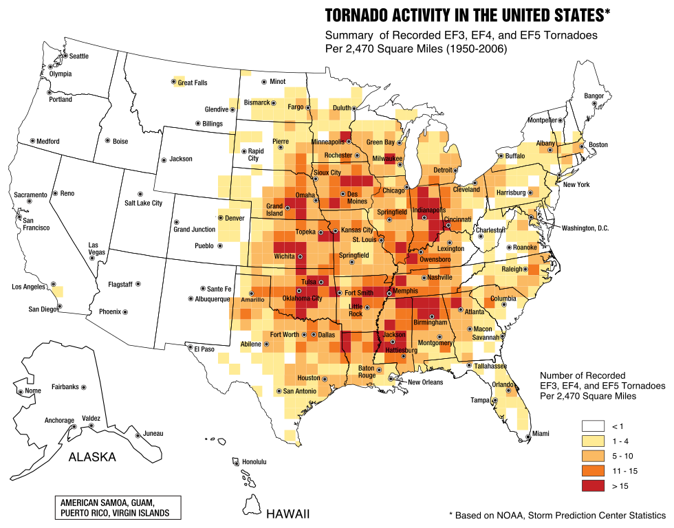
English: A map of the frequency of F3 and greater intensity tornadoes by area. The darker colors highlight the areas typically known as a Tornado Alley. |
| 日期 | |
| 來源 | Image from Federal Emergency Management Agency, a United States government agency, booklet FEMA 320 Third Edition, Section 1, Figure 1.1, page 3, titled Taking Shelter from the Storm: Building a Safe Room Inside your House |
| 作者 | FEMA personnel |
授權條款
|
|
檔案歷史
點選日期/時間以檢視該時間的檔案版本。
| 日期/時間 | 縮圖 | 尺寸 | 用戶 | 備註 | |
|---|---|---|---|---|---|
| 目前 | 2017年5月20日 (六) 23:31 | | 820 × 643(1.26 MB) | Qwewqa | Rotate and add margins |
| 2017年5月20日 (六) 23:03 |  | 651 × 801(1.24 MB) | Qwewqa | Fix background | |
| 2017年5月20日 (六) 22:56 |  | 651 × 801(1.28 MB) | Qwewqa | User created page with UploadWizard |
檔案用途
下列頁面有用到此檔案:
全域檔案使用狀況
以下其他 wiki 使用了這個檔案:
- bg.wikipedia.org 的使用狀況
- br.wikipedia.org 的使用狀況
- el.wikipedia.org 的使用狀況
- en.wikipedia.org 的使用狀況
- he.wikipedia.org 的使用狀況
- th.wikipedia.org 的使用狀況