File:Serbia1941 1944.png

預覽大小:390 × 599 像素。 其他解析度:156 × 240 像素 | 503 × 772 像素。
原始檔案 (503 × 772 像素,檔案大小:39 KB,MIME 類型:image/png)
摘要
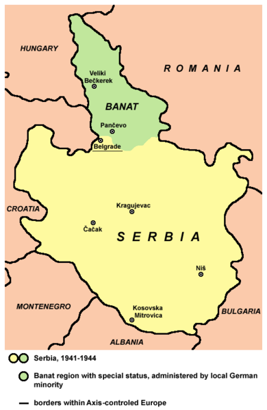
- English: Serbia and Banat, 1941-1944.
- Serbian: Srbija i Banat, 1941-1944. godine.
References
- Istorijski atlas, Geokarta, Beograd, 1999.
- Denis Šehić - Demir Šehić, Školski istorijski atlas Sveta, Beograd, 2007.
- Školski istorijski atlas, Zavod za izdavanje udžbenika SR Srbije, Beograd, 1970.
- Sve srpske mape - od šestog veka do Pariza, Specijalno izdanje BLICA, Decembar 1995. godine.
- The Times - History of Europe, Times Books, London, 2002.
- Richard Overy, The Times - History of the 20th Century, Times Books, London, 2004.
- Valter Manošek, Holokaust u Srbiji, Beograd, 2007.
- Nenad Stefanović, Jedan svet na Dunavu, Beograd, 2003.
- Dr Tomislav Bogavac, Nestajanje Srba, Niš, 1994.
- Petrit Imami, Srbi i Albanci kroz vekove, Beograd, 2000.
- Tim Džuda, Srbi - istorija, mit i razaranje Jugoslavije, Beograd, 2003.
- Fransisko Veiga, Balkanska zamka (1804-2001), Beograd, 2003.
- Džon R. Lempi, Jugoslavija kao istorija, Beograd, 2004.
- http://www.svetskirat.net/slike/razbijanje/zazbijanje_jugoslavije_1941.jpg
- http://www.marxists.org/subject/yugoslavia/images/maps/1941-dismemberment.jpg
- http://www.srpska-mreza.com/MAPS/Yugoslavia/YU-Nazi-division.jpg
- http://terkepek.adatbank.transindex.ro/kepek/netre/211.gif
Source and licence
Self-made map by PANONIAN
| 此作品已由其作者,PANONIAN,釋出至公有領域。此授權條款在全世界均適用。 這可能在某些國家不合法,如果是的話: |

|
This map has been uploaded by Electionworld from en.wikipedia.org to enable the |
檔案歷史
點選日期/時間以檢視該時間的檔案版本。
| 日期/時間 | 縮圖 | 尺寸 | 用戶 | 備註 | |
|---|---|---|---|---|---|
| 目前 | 2012年10月24日 (三) 18:05 | | 503 × 772(39 KB) | PANONIAN | minor aesthetical change |
| 2012年4月26日 (四) 11:45 |  | 503 × 769(39 KB) | PANONIAN | city name | |
| 2009年11月24日 (二) 12:16 |  | 503 × 769(39 KB) | PANONIAN | Reverted to version as of 11:11, 24 November 2009 - fixing thumbnail problem | |
| 2009年11月24日 (二) 12:13 |  | 503 × 769(39 KB) | PANONIAN | Reverted to version as of 11:11, 24 November 2009 - fixing thumbnail problem | |
| 2009年11月24日 (二) 12:12 |  | 588 × 788(18 KB) | PANONIAN | Reverted to version as of 21:25, 31 August 2007 - fixing thumbnail problem | |
| 2009年11月24日 (二) 11:11 |  | 503 × 769(39 KB) | PANONIAN | ||
| 2007年8月31日 (五) 21:25 |  | 588 × 788(18 KB) | PANONIAN | ||
| 2007年3月11日 (日) 13:39 |  | 588 × 788(18 KB) | PANONIAN | Reverted to earlier revision | |
| 2007年3月11日 (日) 12:18 |  | 447 × 630(72 KB) | Ђорђе Божовић | {{ew|en|PANONIAN}} Self-made map by PANONIAN {{PD-user|PANONIAN}} Category:Maps of Serbia | |
| 2006年12月21日 (四) 21:38 |  | 588 × 788(18 KB) | Electionworld | {{ew|en|PANONIAN}} Self-made map by PANONIAN {{PD-user|PANONIAN}} Category:Maps of Serbia |
檔案用途
全域檔案使用狀況
以下其他 wiki 使用了這個檔案:
- bg.wikipedia.org 的使用狀況
- br.wikipedia.org 的使用狀況
- bs.wikipedia.org 的使用狀況
- cs.wikipedia.org 的使用狀況
- de.wikipedia.org 的使用狀況
- el.wikipedia.org 的使用狀況
- en.wikipedia.org 的使用狀況
- fr.wikipedia.org 的使用狀況
- gl.wikipedia.org 的使用狀況
- he.wikipedia.org 的使用狀況
- hr.wikipedia.org 的使用狀況
- it.wikipedia.org 的使用狀況
- ja.wikipedia.org 的使用狀況
- lt.wikipedia.org 的使用狀況
- nl.wikipedia.org 的使用狀況
- pl.wikipedia.org 的使用狀況
- pnb.wikipedia.org 的使用狀況
- pt.wikipedia.org 的使用狀況
- sh.wikipedia.org 的使用狀況
- sv.wikipedia.org 的使用狀況
- tr.wikipedia.org 的使用狀況