File:Rockall EEZ map-en.svg

此 SVG 檔案的 PNG 預覽的大小:455 × 600 像素。 其他解析度:182 × 240 像素 | 364 × 480 像素 | 583 × 768 像素 | 777 × 1,024 像素 | 1,554 × 2,048 像素 | 1,904 × 2,509 像素。
原始檔案 (SVG 檔案,表面大小:1,904 × 2,509 像素,檔案大小:577 KB)
摘要
| 描述 |
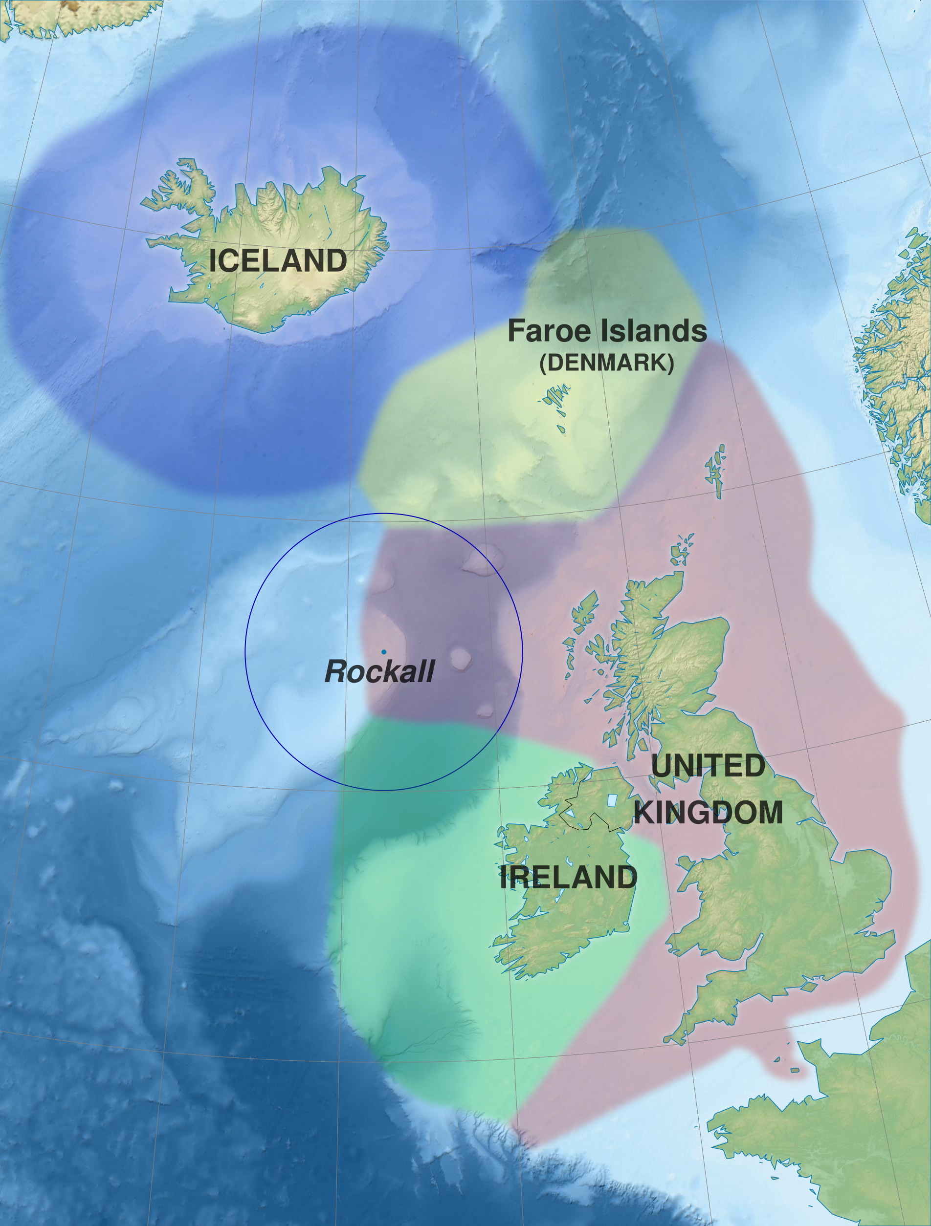
English: Map of exclusive economic zones of the UK, Republic of Ireland, the Faroe Islands (Denmark) and Iceland around Rockall, United Kingdom. Cartographic data :
Français : Carte des zones économiques exclusives du Royaume-Uni, de l'Irlande, des îles Féroé (Danemark) et de l'Islande autour de Rockall (Royaume-Uni). Données cartographiques :
|
||||
| 日期 | (UTC) | ||||
| 來源 |
本檔案衍生自: Rockall EEZ map-fr.svg |
||||
| 作者 | Sémhur (talk) | ||||
| 授權許可 (重用此檔案) |
|||||
| 姓名標示 (由许可协议要求) | © Sémhur / Wikimedia Commons / | ||||
| SVG | W3C-validity not checked.
|
||||
| Graphic Lab | |||||
| 其他版本 |
|

| 拍攝地點 | | 位於此地的本圖片與其他圖片: OpenStreetMap |
|---|
授權條款
我,本作品的著作權持有者,決定用以下授權條款發佈本作品:
| 公共版權:本藝術作品是自由的,您可以依據自由藝術作品許可協議的條款傳播和/或修改本藝術作品。您可以在Copyleft Attitude網站或其他網站找到該許可協議的樣本。 |
This file is licensed under the Creative Commons Attribution-Share Alike Attribution-Share Alike 4.0 International, 3.0 Unported, 2.5 Generic, 2.0 Generic and 1.0 Generic license.
- 您可以自由:
- 分享 – 複製、發佈和傳播本作品
- 重新修改 – 創作演繹作品
- 惟需遵照下列條件:
- 姓名標示 – 您必須指名出正確的製作者,和提供授權條款的連結,以及表示是否有對內容上做出變更。您可以用任何合理的方式來行動,但不得以任何方式表明授權條款是對您許可或是由您所使用。
- 相同方式分享 – 如果您利用本素材進行再混合、轉換或創作,您必須基於如同原先的相同或兼容的條款,來分布您的貢獻成品。
您可以選擇您需要的授權條款。
原始上傳日誌
This image is a derivative work of the following images:
- File:Rockall_EEZ_map-fr.svg licensed with Cc-by-sa-3.0,2.5,2.0,1.0, FAL
- 2012-02-20T21:13:22Z Sémhur 512x675 (590717 Bytes) La ZEE des îles Anglo-normandes rejoint celle de la Grande-Bretagne.
- 2012-02-20T20:52:35Z Sémhur 512x675 (590896 Bytes) + Metadata
- 2012-02-20T20:46:34Z Sémhur 512x675 (589169 Bytes) == {{int:filedesc}} == {{Information |Description={{Multilingual description |en= Map of exclusive economic zones around [[:en:Rockall|]], United Kingdom. |fr= Carte des zones économiques exclusives autour de [[:fr:Rockall|]
Uploaded with derivativeFX
檔案歷史
點選日期/時間以檢視該時間的檔案版本。
| 日期/時間 | 縮圖 | 尺寸 | 用戶 | 備註 | |
|---|---|---|---|---|---|
| 目前 | 2014年5月30日 (五) 09:52 | | 1,904 × 2,509(577 KB) | Sémhur | Valid SVG |
| 2012年2月21日 (二) 13:32 |  | 512 × 675(577 KB) | Sémhur | == {{int:filedesc}} == {{Information |Description={{Multilingual description |en= Map of exclusive economic zones of the UK, Republic of Ireland, the Faroe Islands (Denmark) and Iceland around Rockall, Uni |
檔案用途
下列頁面有用到此檔案:
全域檔案使用狀況
以下其他 wiki 使用了這個檔案:
- ast.wikipedia.org 的使用狀況
- da.wikipedia.org 的使用狀況
- en.wikipedia.org 的使用狀況
- eo.wikipedia.org 的使用狀況
- es.wikipedia.org 的使用狀況
- fr.wikipedia.org 的使用狀況
- hu.wikipedia.org 的使用狀況
- ja.wikipedia.org 的使用狀況
- no.wikipedia.org 的使用狀況
- pl.wikipedia.org 的使用狀況
- sv.wikipedia.org 的使用狀況
- szl.wikipedia.org 的使用狀況
- tr.wikipedia.org 的使用狀況