File:Northern Mali conflict.svg

此 SVG 檔案的 PNG 預覽的大小:629 × 600 像素。 其他解析度:252 × 240 像素 | 503 × 480 像素 | 805 × 768 像素 | 1,074 × 1,024 像素 | 2,148 × 2,048 像素 | 1,316 × 1,255 像素。
原始檔案 (SVG 檔案,表面大小:1,316 × 1,255 像素,檔案大小:796 KB)
摘要
| 描述 |
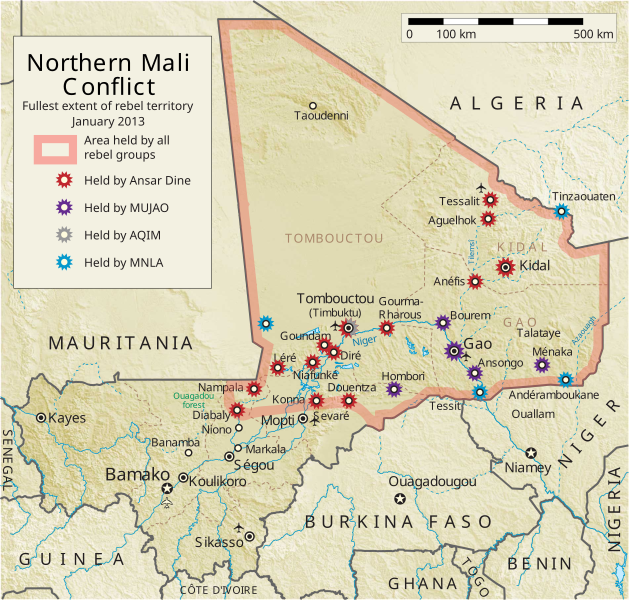
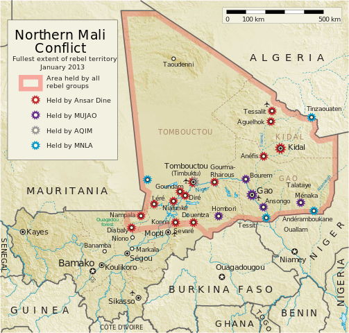
English: Map of the conflict in Northern Mali. (English)
العربية: خريطة الصّراع في شمال مالي. (إنجليزي)
Français : Carte du conflit au nord du Mali. (Anglais)
Latina: Charta rebellionis Tuaregorum in Malia septentrionali. (Anglice)
Українська: Карта конфлікту на півночі Малі. (Англійською) |
| 來源 |
自己的作品 |
| 作者 | Orionist |
| 其他版本 | German/Deutsch/Allemand, French/Français, Macedonian/македонски јазик/Macédonien |
| SVG開發 |
Notes
- ↑ US Department of State, "Country Reports on Terrorism 2011", Chapter 2 Country Reports: Africa Overview, 31 July 2012
授權條款
我,本作品的著作權持有者,決定用以下授權條款發佈本作品:
此檔案採用共享創意 姓名標示-相同方式分享 3.0 未在地化版本授權條款。
- 您可以自由:
- 分享 – 複製、發佈和傳播本作品
- 重新修改 – 創作演繹作品
- 惟需遵照下列條件:
- 姓名標示 – 您必須指名出正確的製作者,和提供授權條款的連結,以及表示是否有對內容上做出變更。您可以用任何合理的方式來行動,但不得以任何方式表明授權條款是對您許可或是由您所使用。
- 相同方式分享 – 如果您利用本素材進行再混合、轉換或創作,您必須基於如同原先的相同或兼容的條款,來分布您的貢獻成品。
檔案歷史
點選日期/時間以檢視該時間的檔案版本。
| 日期/時間 | 縮圖 | 尺寸 | 用戶 | 備註 | |
|---|---|---|---|---|---|
| 目前 | 2014年4月8日 (二) 06:59 | | 1,316 × 1,255(796 KB) | Ansh666 | Reverted to version as of 16:51, 8 March 2013 - restoring the correct version, as the map is supposed to be historical, not current |
| 2013年12月5日 (四) 20:15 |  | 1,316 × 1,255(699 KB) | Hanibal911 | more accurately reflects the situation | |
| 2013年3月8日 (五) 16:51 |  | 1,316 × 1,255(796 KB) | Agricolae | Hombori dot restored | |
| 2013年3月5日 (二) 14:29 |  | 1,316 × 1,255(794 KB) | TUFKAAP | Since this is an English map, Al-Qaeda in the Islamic Maghreb should be abbreviated as AQIM. | |
| 2013年2月11日 (一) 03:33 |  | 1,316 × 1,255(794 KB) | Agricolae | shift text distorted on upload | |
| 2013年2月11日 (一) 03:27 |  | 1,316 × 1,255(794 KB) | Agricolae | change to show greatest extent - see WP Talk:Northern Mali conflict (2012–present) | |
| 2013年2月8日 (五) 06:36 |  | 1,316 × 1,255(699 KB) | Rama | Aguelhok contested or taken ( http://www.lemonde.fr/afrique/article/2013/02/08/mali-les-forces-francaise-et-tchadiennes-a-aguelhok_1828906_3212.html ) | |
| 2013年2月2日 (六) 10:29 |  | 1,316 × 1,255(698 KB) | U5K0 | Bourem to green as per talk page | |
| 2013年1月30日 (三) 08:41 |  | 1,316 × 1,255(679 KB) | Orionist | Updated map: Menaka, Anderamboukane, Ansongo, Dire, Kidal and other MNLA positions. Removed rebel area boundaries as the situation has become complicated. | |
| 2013年1月29日 (二) 17:23 |  | 1,316 × 1,255(894 KB) | Jaybear | Insertion of a map-scale in the upper right corner (added directly before the token "/svg" at end of svg-code); |
檔案用途
下列2個頁面有用到此檔案:
全域檔案使用狀況
以下其他 wiki 使用了這個檔案:
- af.wikipedia.org 的使用狀況
- ar.wikipedia.org 的使用狀況
- azb.wikipedia.org 的使用狀況
- az.wikipedia.org 的使用狀況
- bg.wikipedia.org 的使用狀況
- bn.wikipedia.org 的使用狀況
- ca.wikipedia.org 的使用狀況
- cs.wikipedia.org 的使用狀況
- cy.wikipedia.org 的使用狀況
- da.wikipedia.org 的使用狀況
- de.wikipedia.org 的使用狀況
- el.wikipedia.org 的使用狀況
- en.wikipedia.org 的使用狀況
- Mali
- Portal:Mali
- Insurgency in the Maghreb (2002–present)
- War on terror
- User:Orionist/Gallery
- National Movement for the Liberation of Azawad
- Wikipedia talk:WikiProject Maps/Archive 2012
- Wikipedia:In the news/Candidates/April 2012
- Wikipedia:Graphics Lab/Map workshop/Archive/Apr 2012
- Wikipedia:Wikipedia Signpost/2012-04-30/WikiProject report
- Wikipedia:Wikipedia Signpost/Single/2012-04-30
- Mali War
- Wikipedia:WikiProject Maps/Conventions/Pushpin maps
- Operation Serval
- Chadian intervention in northern Mali
- Islamist insurgency in the Sahel
- User:AlbanianEditor1990/sandbox
- en.wikinews.org 的使用狀況
- eo.wikipedia.org 的使用狀況
- es.wikipedia.org 的使用狀況
- et.wikipedia.org 的使用狀況
- eu.wikipedia.org 的使用狀況
- fi.wikipedia.org 的使用狀況
檢視此檔案的更多全域使用狀況。