File:NEAT GBT engl.png

預覽大小:539 × 600 像素。 其他解析度:216 × 240 像素 | 431 × 480 像素 | 852 × 948 像素。
原始檔案 (852 × 948 像素,檔案大小:1.91 MB,MIME 類型:image/png)
摘要
| 描述 |
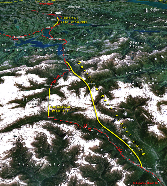
Situation of the northern part of the Gotthard axis as part of the New Railway Link through the Alps NRLA / Alptransit project in Switzerland with Gotthard and Zimmerberg base tunnels |
| 日期 | |
| 來源 | topomap: produced with NASA WorldWind 1.3 / overlay drawing by: Cooper.ch |
| 作者 | --Cooper.ch 19:30, 12 August 2006 (UTC) |
| 授權許可 (重用此檔案) |
NASA satellite imagery is in public domain, and so is my overlay drawing |
| 其他版本 | Original german version on de.wikipedia.org, named Bild:NEAT_Gotthardachse.png |
授權條款
| 本作品由NASA創作,屬於公有領域。根據NASA的版權政策:“NASA的創作除非另有聲明否則不受版權保護。”(參見:Template:PD-USGov/zh,NASA版權政策或JPL圖像使用政策) | ||
 |
警告:
|
| 註解 | 該圖片含有註解:在維基媒體共享資源上查看註解 |


檔案歷史
點選日期/時間以檢視該時間的檔案版本。
| 日期/時間 | 縮圖 | 尺寸 | 用戶 | 備註 | |
|---|---|---|---|---|---|
| 目前 | 2006年8月12日 (六) 19:30 | | 852 × 948(1.91 MB) | Cooper.ch | {{Information |Description=Situation of the northern axis of the New Railway Link through the Alps NRLA in Switzerland with Gotthard and Zimmerberg base tunnels |Source=topomap: produced with NASA WorldWind 1.3 / drawing overlay by: [[User:Cooper.ch|Coope |
檔案用途
下列2個頁面有用到此檔案:
全域檔案使用狀況
以下其他 wiki 使用了這個檔案:
- ast.wikipedia.org 的使用狀況
- bh.wikipedia.org 的使用狀況
- da.wikipedia.org 的使用狀況
- en.wikipedia.org 的使用狀況
- es.wikipedia.org 的使用狀況
- fa.wikipedia.org 的使用狀況
- fi.wikipedia.org 的使用狀況
- fr.wikipedia.org 的使用狀況
- he.wikipedia.org 的使用狀況
- hr.wikipedia.org 的使用狀況
- ja.wikipedia.org 的使用狀況
- jv.wikipedia.org 的使用狀況
- ml.wikipedia.org 的使用狀況
- my.wikipedia.org 的使用狀況
- nl.wikipedia.org 的使用狀況
- no.wikipedia.org 的使用狀況
- pt.wikipedia.org 的使用狀況
- rm.wikipedia.org 的使用狀況
- ro.wikipedia.org 的使用狀況
- sh.wikipedia.org 的使用狀況
- sl.wikipedia.org 的使用狀況
- sv.wikipedia.org 的使用狀況
- ta.wikinews.org 的使用狀況
- tr.wikipedia.org 的使用狀況