File:England-878ad.jpg

預覽大小:471 × 599 像素。 其他解析度:189 × 240 像素 | 377 × 480 像素 | 735 × 935 像素。
原始檔案 (735 × 935 像素,檔案大小:127 KB,MIME 類型:image/jpeg)

|
This map has been uploaded by Electionworld from en.wikipedia.org to enable the |
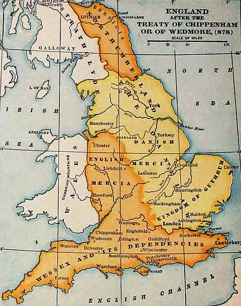
England and Wales at the time of the Treaty of Chippenham (AD 878). From the Atlas of European History, Earle W Dowe (d. 1946), G Bell and Sons, London, 1910
[]
-
 Cymraeg
 -
 Deutsch
 -
 English
 -
 English
 -
 English
 -
 español
 -
 français
 -
 Nederlands
 -
 polski
 -
 magyar


.svg)


|
本作品作者於1946年逝世,在其來源國以及其他版權期限是作者逝世後75年或以下的國家與地區屬於公有領域。 | |
| 此作品無已知的著作權限制,亦不受所有相關和鄰接的權利限制。 | |
檔案歷史
點選日期/時間以檢視該時間的檔案版本。
| 日期/時間 | 縮圖 | 尺寸 | 用戶 | 備註 | |
|---|---|---|---|---|---|
| 目前 | 2011年11月7日 (一) 19:27 | | 735 × 935(127 KB) | Hel-hama | same source, better version of the image |
| 2006年12月29日 (五) 15:49 |  | 693 × 879(79 KB) | Electionworld | {{ew|en|Adamsan}} England and Wales at the time of the Treaty of Chippenham (AD 878). From the Atlas of European History, Earle W Dowe, G Bell and Sons, London, 1910 {{PD-US}} |
檔案用途
下列頁面有用到此檔案:
全域檔案使用狀況
以下其他 wiki 使用了這個檔案:
- ar.wikipedia.org 的使用狀況
- br.wikipedia.org 的使用狀況
- cs.wikipedia.org 的使用狀況
- en.wikipedia.org 的使用狀況
- Talk:Sub-Roman Britain
- Portal:Denmark/Selected article/2006 archive
- Portal:Denmark/Selected article/Week 20, 2006
- Portal:Denmark/Selected article/2007 archive
- Portal:Denmark/Selected article/Week 4, 2007
- Portal:Denmark/Selected article/Week 5, 2007
- Portal:Denmark/Selected article/Week 45, 2007
- Portal:Denmark/Selected article/Week 46, 2007
- Portal:Denmark/Selected article/2008 archive
- Portal:Denmark/Selected article/Week 3, 2008
- User:Amitchell125/danelaw
- eo.wikipedia.org 的使用狀況
- fa.wikipedia.org 的使用狀況
- fy.wikipedia.org 的使用狀況
- hu.wikipedia.org 的使用狀況
- id.wikipedia.org 的使用狀況
- is.wikipedia.org 的使用狀況
- it.wikipedia.org 的使用狀況
- ja.wikipedia.org 的使用狀況
- pt.wikipedia.org 的使用狀況
- sh.wikipedia.org 的使用狀況
- simple.wikipedia.org 的使用狀況
- sk.wikipedia.org 的使用狀況
- th.wikipedia.org 的使用狀況
- uk.wikipedia.org 的使用狀況