File:Ball's Pyramid2.jpg
此為最大尺寸。
Ball's_Pyramid2.jpg (317 × 356 像素,檔案大小:22 KB,MIME 類型:image/jpeg)
摘要
| 描述 |
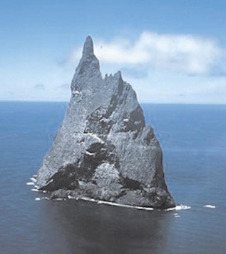
English: Aerial view of Ball’s Pyramid, Lord Howe Island Group, NSW, Australia |
| 日期 | not specified |
| 來源 | http://pollux.nss.nima.mil/NAV_PUBS/SD/Pub127/, page 105 (jpg extracted from pdf document) |
| 作者 | National Imagery and Mapping Agency (NIMA), now National Geospatial-Intelligence Agency |
授權條款
This image is a work of the United States National Geospatial-Intelligence Agency or one of its predecessor agencies. As a work of the U.S. federal government, the image is in the public domain.
|
 |
原始上傳日誌
(All user names refer to en.wikipedia)
- 2006-02-25 21:36 Ratzer 317×356 (22022 bytes) (http://pollux.nss.nima.mil/NAV_PUBS/SD/Pub127/, page 105 (jpg extracted from pdf document))
檔案歷史
點選日期/時間以檢視該時間的檔案版本。
| 日期/時間 | 縮圖 | 尺寸 | 用戶 | 備註 | |
|---|---|---|---|---|---|
| 目前 | 2006年8月21日 (一) 19:08 | | 317 × 356(22 KB) | Liftarn | {{Information| |Description=Ball's Pyramid |Source=http://pollux.nss.nima.mil/NAV_PUBS/SD/Pub127/, page 105 (jpg extracted from pdf document) |Date= |Author=User Ratzer on [http://en.wikipedia.org en.wikipedia] |Permission={{PD-USGov}} |
檔案用途
下列頁面有用到此檔案:
全域檔案使用狀況
以下其他 wiki 使用了這個檔案:
- ar.wikipedia.org 的使用狀況
- az.wikipedia.org 的使用狀況
- be.wikipedia.org 的使用狀況
- bg.wikipedia.org 的使用狀況
- cs.wikipedia.org 的使用狀況
- de.wikipedia.org 的使用狀況
- el.wikipedia.org 的使用狀況
- en.wikipedia.org 的使用狀況
- es.wikipedia.org 的使用狀況
- frr.wikipedia.org 的使用狀況
- fy.wikipedia.org 的使用狀況
- he.wikipedia.org 的使用狀況
- hr.wikipedia.org 的使用狀況
- hu.wikipedia.org 的使用狀況
- hyw.wikipedia.org 的使用狀況
- id.wikipedia.org 的使用狀況
- it.wikipedia.org 的使用狀況
- ka.wikipedia.org 的使用狀況
- ksh.wikipedia.org 的使用狀況
- ky.wikipedia.org 的使用狀況
- lt.wikipedia.org 的使用狀況
- ms.wikipedia.org 的使用狀況
- nn.wikipedia.org 的使用狀況
- no.wikipedia.org 的使用狀況
- pl.wikipedia.org 的使用狀況
- pt.wikipedia.org 的使用狀況
- ru.wikipedia.org 的使用狀況
- sh.wikipedia.org 的使用狀況
檢視此檔案的更多全域使用狀況。