File:Quebec province topographic map-fr.svg

此 SVG 檔案的 PNG 預覽的大小:484 × 600 像素。 其他解析度:194 × 240 像素 | 387 × 480 像素 | 620 × 768 像素 | 826 × 1,024 像素 | 1,652 × 2,048 像素 | 1,261 × 1,563 像素。
原始檔案 (SVG 檔案,表面大小:1,261 × 1,563 像素,檔案大小:956 KB)
This image was selected as picture of the day on Wikimedia Commons for 25 November 2009. It was captioned as follows: Other languages:
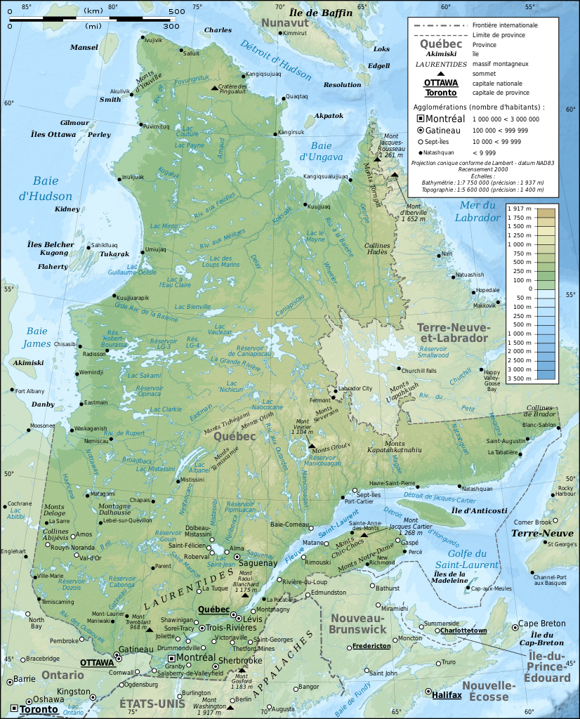
Bosanski: Topografska mapa Kvebeka (Kanada) na francuskom sa gradovima iz popisa 2000. Français : Carte topographique en français du Québec, Canada, avec agglomérations suivant le recensement de 2000. Italiano: Carta topografica in francese della provincia canadese del Québec aggiornata secondo i dati del censimento del 2000. Magyar: A kanadai Québec tartomány francia nyelvű topográfiai térképe a 2000-es népszámlálás szerinti városok feltüntetésével Nederlands: Franstalige topografische kaart van de Canadese (Franssprekende) provincie Québec met de steden van de volkstelling van 2002 Polski: Topograficzna mapa Quebecu (Kanada) w języku francuskim. Português: Mapa topográfico em francês do Quebeque, Canadá, com as cidades do censo de 2000. Македонски: Топографска карта на покраината Квебек, Канада, на француски јазик. Русский: Физическая карта провинции Квебек (Канада) на французском языке. Использованы данные переписи 2000 года. Українська: Фізична карта провінції Квебек, Канада французькою мовою. Наведені дані перепису населення 2000 року. বাংলা : ফরাসী ভাষায় লিখিত কানাডার, কুইবেক অঙ্গরাজ্যের প্রাকৃতিক মানচিত্র। প্রায় ২০০০ শহর উল্লেখিত রয়েছে। 中文: 加拿大魁北克地形学法文地图,根据2000年城市人口普查数据绘制 中文(繁體): 加拿大魁北克地形學法文地圖,根據2000年城市人口普查數據繪製 |
|

摘要
| 拍攝地點 | | 位於此地的本圖片與其他圖片: OpenStreetMap |
|---|
| 描述 |
English: Topographic map in French of Quebec, Canada, with 2000' census cities. Note: The background map is a raster image embedded in the SVG file. Français : Carte topographique en français du Québec, Canada, avec agglomérations suivant le recensement de 2000.
Note : Le fond de carte est une image bitmap embarquée dans le fichier SVG.
|
||
| 日期 | |||
| 來源 |
Own work ;
|
||
| 作者 | Eric Gaba (Sting - fr:Sting) | ||
| 授權許可 (重用此檔案) |
|
||
| 其他版本 |
[]
Same base map but with topography and without transportation:
Same map, but with an extra layer containing locations of Hydro-Québec's generating stations and 735 kV lines and substations
|


|
This SVG file contains embedded text that can be translated into your language, using any capable SVG editor, text editor or the SVG Translate tool. For more information see: About translating SVG files. |
授權條款
我,本作品的著作權持有者,決定用以下授權條款發佈本作品:

|
已授權您依據自由軟體基金會發行的無固定段落、封面文字和封底文字GNU自由文件授權條款1.2版或任意後續版本,對本檔進行複製、傳播和/或修改。該協議的副本列在GNU自由文件授權條款中。 |
This file is licensed under the Creative Commons Attribution-Share Alike Attribution-Share Alike 4.0 International, 3.0 Unported, 2.5 Generic, 2.0 Generic and 1.0 Generic license.
- 您可以自由:
- 分享 – 複製、發佈和傳播本作品
- 重新修改 – 創作演繹作品
- 惟需遵照下列條件:
- 姓名標示 – 您必須指名出正確的製作者,和提供授權條款的連結,以及表示是否有對內容上做出變更。您可以用任何合理的方式來行動,但不得以任何方式表明授權條款是對您許可或是由您所使用。
- 相同方式分享 – 如果您利用本素材進行再混合、轉換或創作,您必須基於如同原先的相同或兼容的條款,來分布您的貢獻成品。
您可以選擇您需要的授權條款。
檔案歷史
點選日期/時間以檢視該時間的檔案版本。
| 日期/時間 | 縮圖 | 尺寸 | 用戶 | 備註 | |
|---|---|---|---|---|---|
| 目前 | 2009年3月3日 (二) 13:43 | | 1,261 × 1,563(956 KB) | Sting | Correction ; + additional labels |
| 2009年3月3日 (二) 00:04 |  | 1,261 × 1,563(949 KB) | Sting | == Summary == {{Location|54|00|00|N|68|30|00|W|scale:10000000}} <br/> {{Information |Description={{en|Topographic map in French of Quebec, Canada, with 2000' census cities.}} {{fr|Carte topographique en français du [[:fr:Qu� |
檔案用途
下列2個頁面有用到此檔案:
全域檔案使用狀況
以下其他 wiki 使用了這個檔案:
- af.wikipedia.org 的使用狀況
- ba.wikipedia.org 的使用狀況
- bn.wikipedia.org 的使用狀況
- crh.wikipedia.org 的使用狀況
- cs.wikipedia.org 的使用狀況
- cv.wikipedia.org 的使用狀況
- da.wikipedia.org 的使用狀況
- en.wikipedia.org 的使用狀況
- et.wikipedia.org 的使用狀況
- frp.wikipedia.org 的使用狀況
- fr.wikipedia.org 的使用狀況
- Géographie du Québec
- Utilisateur:Sting
- Québec
- Araignées du Québec
- Wikipédia:Image du jour/mars 2009
- Projet:Cartographie/Cartes standards/Pays
- Wikipédia:Atelier graphique/Cartes/Archives/mars 2009
- Wikipédia:Image du jour/29 mars 2009
- Wikipédia:Atelier graphique/Cartes/Archives/juin 2009
- Wikipédia:Atelier graphique/Cartes/Archives/avril 2010
- Wikipédia:Atelier graphique/Cartes/Archives/Demandes mises en sommeil/Europe
- hu.wikipedia.org 的使用狀況
- is.wikipedia.org 的使用狀況
- ko.wikipedia.org 的使用狀況
- krc.wikipedia.org 的使用狀況
- lbe.wikipedia.org 的使用狀況
- lmo.wikipedia.org 的使用狀況
- mk.wikipedia.org 的使用狀況
- nl.wikipedia.org 的使用狀況
- oc.wikipedia.org 的使用狀況
- os.wikipedia.org 的使用狀況
- pam.wikipedia.org 的使用狀況
- pl.wikipedia.org 的使用狀況
- pt.wikipedia.org 的使用狀況
- ru.wikipedia.org 的使用狀況
- ru.wikinews.org 的使用狀況
- sah.wikipedia.org 的使用狀況
- sn.wikipedia.org 的使用狀況
- sv.wikipedia.org 的使用狀況
- uk.wikipedia.org 的使用狀況
檢視此檔案的更多全域使用狀況。