File:Pipelines in Eastern Europe.png
此為最大尺寸。
Pipelines_in_Eastern_Europe.png (643 × 474 像素,檔案大小:71 KB,MIME 類型:image/png)
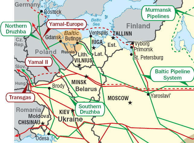
Pipelines in Eastern Europe. Red: gas pipelines. Green: oil pipelines. Dashed: planned pipelines. Brown: prospective region.
Cropped from http://www.eia.doe.gov/emeu/cabs/Russia/images/fsu_energymap.pdf See [1] for context.
| 此圖像是美國能源部(或前身組織)的僱員於其公務中所作之作品。由於此作品由美國聯邦政府所作,其處於公有領域。
請注意美國國家實驗室使用不同授權條款而其中部分為自由條款。檢查實驗室的網站政策後才可使用此標籤。
|

|
檔案歷史
點選日期/時間以檢視該時間的檔案版本。
| 日期/時間 | 縮圖 | 尺寸 | 用戶 | 備註 | |
|---|---|---|---|---|---|
| 目前 | 2011年6月2日 (四) 19:04 | | 643 × 474(71 KB) | Ras67 | cropped |
| 2010年6月30日 (三) 09:01 |  | 654 × 483(89 KB) | Ds02006 | Corrected the border between Romania and the Ukraine | |
| 2007年1月9日 (二) 22:26 |  | 654 × 483(50 KB) | Conscious | +border | |
| 2007年1月9日 (二) 22:17 |  | 654 × 483(51 KB) | Conscious | Pipelines in Eastern Europe. Red: gas pipelines. Green: oil pipelines. Dashed: planned pipelines. Brown: prospective region. Cropped from http://www.eia.doe.gov/emeu/cabs/Russia/images/fsu_energymap.pdf {{PD-US-DoE}} Category:Maps of Europe |
檔案用途
下列4個頁面有用到此檔案:
全域檔案使用狀況
以下其他 wiki 使用了這個檔案:
- ar.wikipedia.org 的使用狀況
- az.wikipedia.org 的使用狀況
- be-tarask.wikipedia.org 的使用狀況
- be.wikipedia.org 的使用狀況
- bg.wikipedia.org 的使用狀況
- de.wikipedia.org 的使用狀況
- en.wikipedia.org 的使用狀況
- fi.wikipedia.org 的使用狀況
- fr.wikipedia.org 的使用狀況
- hy.wikipedia.org 的使用狀況
- it.wikipedia.org 的使用狀況
- ko.wikipedia.org 的使用狀況
- nl.wikipedia.org 的使用狀況
- pl.wikipedia.org 的使用狀況
- pt.wikipedia.org 的使用狀況
- ru.wikipedia.org 的使用狀況
- ru.wikinews.org 的使用狀況
- uk.wikipedia.org 的使用狀況
- Нафтопровід Одеса — Броди
- Дружба (нафтопровід)
- Магістральний нафтопровід
- Балтійська трубопровідна система
- Транспорт України
- Користувач:Alex Blokha/Дні згадані в Вікіпедії/Україна/10 жовтня
- Користувач:Alex Blokha/Дні згадані в Вікіпедії/Україна/13 жовтня
- Користувач:Alex Blokha/Дні згадані в Вікіпедії/Україна/15 жовтня
- Користувач:Alex Blokha/Дні згадані в Вікіпедії/Україна/4 листопада
- Користувач:Alex Blokha/Дні згадані в Вікіпедії/Україна/10 грудня
- Користувач:Alex Blokha/Дні згадані в Вікіпедії/Україна/12 грудня
- Користувач:Alex Blokha/Дні згадані в Вікіпедії/Україна/18 грудня
- Користувач:Alex Blokha/Дні згадані в Вікіпедії/Україна/19 грудня
- Користувач:Alex Blokha/Дні згадані в Вікіпедії/Україна/26 грудня
- Користувач:Alex Blokha/Дні згадані в Вікіпедії/Україна/28 січня
- Користувач:Alex Blokha/Дні згадані в Вікіпедії/Україна/6 лютого
- Користувач:Alex Blokha/Дні згадані в Вікіпедії/Україна/13 лютого
- Користувач:Alex Blokha/Дні згадані в Вікіпедії/Україна/19 квітня
- Користувач:Alex Blokha/Дні згадані в Вікіпедії/Україна/29 квітня
- Користувач:Alex Blokha/Дні згадані в Вікіпедії/Україна/23 червня
檢視此檔案的更多全域使用狀況。