File:NintokuTomb.jpg

預覽大小:600 × 600 像素。 其他解析度:240 × 240 像素 | 480 × 480 像素 | 769 × 768 像素 | 1,025 × 1,024 像素 | 1,345 × 1,344 像素。
原始檔案 (1,345 × 1,344 像素,檔案大小:2.38 MB,MIME 類型:image/jpeg)
| 描述 |
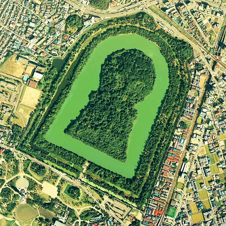
Daisen-kofun in Sakai, Osaka, Japan. This is one of the largest tombs in the world. Japanese government regards this as the tomb of Emperor Nintoku, the 16th emperor, but many historians don't think so. The keyhole-like tomb is 486m long, 305m wide at the bottom and 245m in diameter. English: Daisen-Kofun, the tomb of Emperor Nintoku, Osaka
Español: El Daisen-Kofun, tumba legendaria de Emperador Nintoku
Suomi: Kofun-kauden hautakumpu Osakassa, yksi maailman suurimmista. |
| 日期 | |
| 來源 | http://w3land.mlit.go.jp/cgi-bin/WebGIS2/WC_AirPhoto.cgi?IT=p&DT=n&PFN=CKK-85-2&PCN=C2&IDX=8 |
| 作者 | Ministry of Land, Infrastructure and Transport Government of Japan & moja resized |
| 授權許可 (重用此檔案) |
GFDL |
| 拍攝地點 | | 位於此地的本圖片與其他圖片: OpenStreetMap |
|---|
- 仁徳天皇陵とされる古墳
- ソース
- 整理番号:CKK852-C2-8
- 撮影:1985年(昭和60年)

|
本檔案的著作權持有者,國土交通省,在註明所有人姓名的前提下,允許任何人使用本檔案於任何用途。包含再散布、衍生作品、商業用途及其他用途。 |
姓名標示:
Copyright © 地图/航拍图浏览服务 国土地理院
|
 |
此图像的版权归日本地理空间信息管理局所有。请参阅地图/航空照片查看服务使用条款和来自国土交通省的消息和旅游使用条款......。当您在文章上显示此图像时,请在说明中包含以下短语:“基于[https://mapps.gsi.go.jp/maplibSearch.do#1 National Land Image Information (颜色航拍照片)],国土交通省”。
|
檔案歷史
點選日期/時間以檢視該時間的檔案版本。
| 日期/時間 | 縮圖 | 尺寸 | 用戶 | 備註 | |
|---|---|---|---|---|---|
| 目前 | 2020年6月7日 (日) 09:19 | | 1,345 × 1,344(2.38 MB) | 名古屋太郎 | 明るさ等変更 |
| 2005年8月17日 (三) 20:44 |  | 800 × 800(515 KB) | Moja~commonswiki | {{Information| |Description=Daisen-kofun in Sakai, Osaka, Japan. This is one of the largest tombs in the world. Japanese gorvernment regards this as the tomb of Emperor Nintoku, the 16th emperor, but many historians doubt don't think so. The keyhole-lik |
檔案用途
下列頁面有用到此檔案:
全域檔案使用狀況
以下其他 wiki 使用了這個檔案:
- en.wikipedia.org 的使用狀況
- fr.wikipedia.org 的使用狀況
- ja.wikipedia.org 的使用狀況
- www.wikidata.org 的使用狀況