File:Lake Chad’s shrinking waters ESA418540.gif
原始檔案 (2,802 × 2,802 像素,檔案大小:11.7 MB,MIME 類型:image/gif、循環、2 畫格、6.0秒)
摘要
| 描述 |
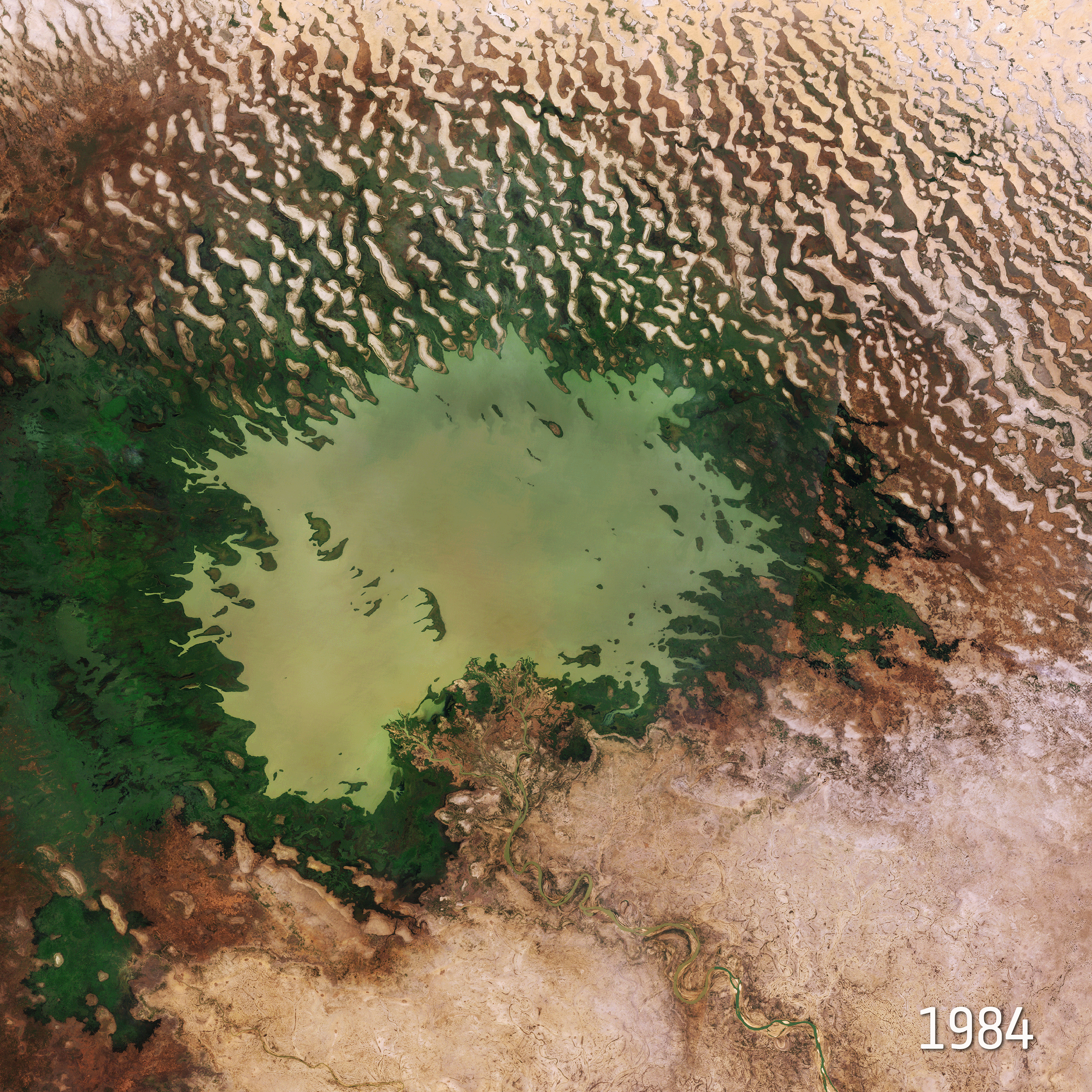
English: The 22 March isWorld Water Day, which focuses on the importance of freshwater. The Sustainable Development Goals of the United Nations aim to achieve a better and more sustainable future. Goal number 6 focuses on ensuring the availability and sustainable management of water for all by 2030. This image takes us over Lake Chad at the southern edge of the Sahara, where water supplies are dwindling.
This comparison shows Lake Chad imaged on 6 November 1984 by the US Landsat 5 satellite and on 31 October 2018 by the Copernicus Sentinel-2A satellite. The rapid decline of the lake’s waters in just 34 years is clear to see. Once one of Africa’s largest lakes, Lake Chad has shrunk by around 90% since the 1960s. This receding water is down to a reduction of precipitation, induced by climate change, as well as development of modern irrigation systems for agriculture and the increasing human demand for freshwater. Straddling the border of Chad, Niger, Cameroon and Nigeria, the lake is a major source of freshwater for millions of people in the area. It is also a source for irrigation, fishing and it was once rich in biodiversity. As the lake continues to dry up, many farmers and herders move towards greener areas or move to larger cities to seek alternative work. Several attempts have been made to replenish these shrinking waters, however little progress has been achieved. The borders of the lake’s body are only partly visible in the most-recent image – as the majority of the shoreline is swamp and marsh. The Chari River, visible snaking its way towards Lake Chad at the bottom of the image, provides over 90% of the lake’s waters. It flows from the Central African Republic following the Cameroon border from N'Djamena, where it joins with its main tributary the Logone River. The demand for water is growing inexorably. Access to water is vital – not only for drinking, but also for agriculture, energy and sanitation. By providing measurements of water quality and detecting changes, the Copernicus Sentinel-2 mission can support the sustainable management of water resources. These images are also featured on theEarth from Space video programme. UN Sustainable Goal 6 is crystal clear: Water for all by 2030. SDG6 includes a target to ensure availability and sustainable management of water for all by 2030. For World Water Day we take a look at ways that space can help this global challenge. While Earth-observing satellites monitor our precious water resources, technologies developed for human space missions also serve global needs in harsh environments here on Earth. |
| 日期 | |
| 來源 | http://www.esa.int/spaceinimages/Images/2019/03/Lake_Chad_s_shrinking_waters |
| 作者 | European Space Agency |
| 授權許可 (重用此檔案) |
contains modified Copernicus Sentinel data (2018), processed by ESA (For Landsat image: USGS/ESA),CC BY-SA 3.0 IGO |
| Title | Lake Chad’s shrinking waters |
| System | Landsat-5 |
| Set | Earth observation image of the week |
| Mission | Sentinel-2 |
| Activity | Observing the Earth |
授權條款
- 您可以自由:
- 分享 – 複製、發佈和傳播本作品
- 重新修改 – 創作演繹作品
- 惟需遵照下列條件:
- 姓名標示 – 您必須指名出正確的製作者,和提供授權條款的連結,以及表示是否有對內容上做出變更。您可以用任何合理的方式來行動,但不得以任何方式表明授權條款是對您許可或是由您所使用。
- 相同方式分享 – 如果您利用本素材進行再混合、轉換或創作,您必須基於如同原先的相同或兼容的條款,來分布您的貢獻成品。

|
此图像包含来自哥白尼计划中的卫星的数据,例如哨兵1号、哨兵2号或哨兵3号。使用此图片时需要注明出处。
姓名標示: 包含修改后的哥白尼哨兵数据{{{year}}}
哥白尼哨兵数据的使用受欧盟法律监管(委员会授权条例 (EU) No 1159/2013和条例 (EU) No 377/2014)。相关摘录:
应免费访问通过GMES传播平台提供的GMES专用数据[...]。
在合法的范围内应出于以下用途的目的访问GMES专用数据[...]:
GMES专用数据[...]可在全球范围内不受时间限制地使用。
向用户提供GMES专用数据和GMES服务信息没有任何明示或暗示的保证,包括关于质量和任何目的的适用性。 |
檔案歷史
點選日期/時間以檢視該時間的檔案版本。
| 日期/時間 | 縮圖 | 尺寸 | 用戶 | 備註 | |
|---|---|---|---|---|---|
| 目前 | 2019年4月3日 (三) 12:24 | | 2,802 × 2,802(11.7 MB) | Fæ | European Space Agency, Id 418540, http://www.esa.int/spaceinimages/Images/2019/03/Lake_Chad_s_shrinking_waters, User:Fæ/Project_list/ESA |
檔案用途
下列頁面有用到此檔案:
全域檔案使用狀況
以下其他 wiki 使用了這個檔案:
- af.wikipedia.org 的使用狀況
- en.wikipedia.org 的使用狀況
- hy.wikipedia.org 的使用狀況
- ig.wikipedia.org 的使用狀況