File:Katrina-new-orleans-flooding3-2005.jpg
預覽大小:800 × 600 像素。 其他解析度:320 × 240 像素 | 640 × 480 像素 | 1,024 × 768 像素 | 1,280 × 960 像素 | 1,600 × 1,200 像素。
原始檔案 (1,600 × 1,200 像素,檔案大小:1.05 MB,MIME 類型:image/jpeg)
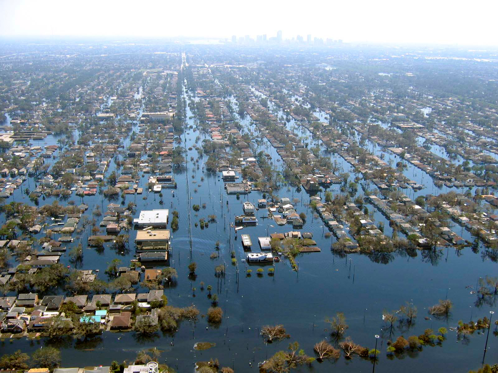
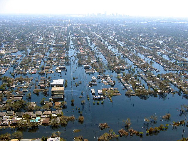
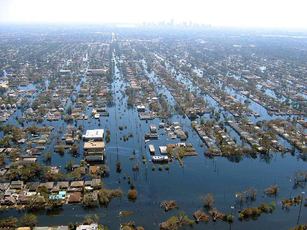
| 描述 | View of flooded New Orleans, Louisiana in the aftermath of Hurricane Katrina | |||
| 日期 | ||||
| 來源 | http://www.katrina.noaa.gov/helicopter/helicopter-2.html | |||
| 作者 | Commander Mark Moran, of the NOAA Aviation Weather Center, and Lt. Phil Eastman and Lt. Dave Demers, of the NOAA Aircraft Operations Center, all commissioned officers of the NOAA Corps, flew more than 100 hours surveying Katrina’s devastation. Eastman piloted NOAA’s Bell 212 Twin Huey Helicopter from August 31 to September 19. All three men took dozens of aerial photos from an altitude of several feet to 500 feet. | |||
| 授權許可 (重用此檔案) |
|
檔案歷史
點選日期/時間以檢視該時間的檔案版本。
| 日期/時間 | 縮圖 | 尺寸 | 用戶 | 備註 | |
|---|---|---|---|---|---|
| 目前 | 2008年4月22日 (二) 22:10 | | 1,600 × 1,200(1.05 MB) | Mfield | {{Information |Description=View of flooded New Orleans, Louisiana in the aftermath of Hurricane Katrina |Source=http://www.katrina.noaa.gov/helicopter/helicopter-2.html |Date=11 Sept 2005 |Author=Commander Mark Moran, of the NOAA Aviation Weather Center, |
| 2008年4月22日 (二) 22:07 |  | 1,600 × 1,200(264 KB) | Mfield | {{Information |Description=View of flooded New Orleans, Louisiana in the aftermath of Hurricane Katrina |Source=http://www.katrina.noaa.gov/helicopter/helicopter-2.html |Date=11 Sept 2005 |Author=Commander Mark Moran, of the NOAA Aviation Weather Center, |
檔案用途
下列3個頁面有用到此檔案:
全域檔案使用狀況
以下其他 wiki 使用了這個檔案:
- bn.wikipedia.org 的使用狀況
- de.wikipedia.org 的使用狀況
- dty.wikipedia.org 的使用狀況
- en.wikipedia.org 的使用狀況
- et.wikipedia.org 的使用狀況
- eu.wikipedia.org 的使用狀況
- fa.wikipedia.org 的使用狀況
- fr.wikipedia.org 的使用狀況
- hy.wikipedia.org 的使用狀況
- id.wikipedia.org 的使用狀況
- ig.wikipedia.org 的使用狀況
- pl.wikipedia.org 的使用狀況
- pt.wikipedia.org 的使用狀況
- ru.wikipedia.org 的使用狀況
- sk.wikipedia.org 的使用狀況
- sv.wikipedia.org 的使用狀況
- sw.wikipedia.org 的使用狀況
- tr.wikipedia.org 的使用狀況
- uk.wikipedia.org 的使用狀況
- ur.wikipedia.org 的使用狀況