File:Cut Map of the Hala'ib triangle.jpg

預覽大小:800 × 353 像素。 其他解析度:320 × 141 像素 | 640 × 283 像素 | 1,024 × 452 像素 | 1,280 × 565 像素 | 2,560 × 1,130 像素 | 8,567 × 3,782 像素。
原始檔案 (8,567 × 3,782 像素,檔案大小:21.78 MB,MIME 類型:image/jpeg)
| 描述 |
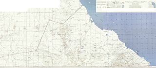
Deutsch: Karte des Hala’ib-Dreiecks English: Map of the Hala'ib triangle |
| 日期 | Original:1954 Edited:2010-06-19 17:01 (UTC) |
| 來源 | |
| 作者 |
|
| 這是一張修飾過的圖片,即本圖片是用軟體修改過後的版本,修改的方式或內容有:cut to smaller size, legend elements pasted to top right。原版圖片來源:Map of the Hala'ib triangle.jpg。修改者:Ratzer1。
|
|
|
 |
原始上傳日誌
This image is a derivative work of the following images:
- File:Map_of_the_Hala'ib_triangle.jpg licensed with PD-USGov-Military-Army
- 2010-06-17T20:47:01Z Chumwa 12962x6841 (17578828 Bytes) {{Information |Description= {{de|Karte des Hala’ib-Dreiecks}} {{en|Map of the Hala'ib triangle}} |Source=The following map sheets of the North Africa 1:250,000 Series P502 by the U.S. Army Map Service: * [[:Image:Txu-oclc-
Uploaded with derivativeFX
檔案歷史
點選日期/時間以檢視該時間的檔案版本。
| 日期/時間 | 縮圖 | 尺寸 | 用戶 | 備註 | |
|---|---|---|---|---|---|
| 目前 | 2010年6月19日 (六) 17:09 | | 8,567 × 3,782(21.78 MB) | Ratzer | {{Information |Description={{de|Karte des Hala’ib-Dreiecks}} {{en|Map of the Hala'ib triangle}} |Source=*File:Map_of_the_Hala'ib_triangle.jpg |Date=2010-06-19 17:01 (UTC) |Author=*File:Map_of_the_Hala'ib_triangle.jpg: [[:de:User:Chumwa|Maxim |
檔案用途
下列頁面有用到此檔案:
全域檔案使用狀況
以下其他 wiki 使用了這個檔案:
- ar.wikipedia.org 的使用狀況
- az.wikipedia.org 的使用狀況
- ca.wikipedia.org 的使用狀況
- de.wikipedia.org 的使用狀況
- en.wikipedia.org 的使用狀況
- es.wikipedia.org 的使用狀況
- fi.wikipedia.org 的使用狀況
- fr.wikipedia.org 的使用狀況
- he.wikipedia.org 的使用狀況
- it.wikipedia.org 的使用狀況
- ja.wikipedia.org 的使用狀況
- nl.wikipedia.org 的使用狀況
- no.wikipedia.org 的使用狀況
- ru.wikipedia.org 的使用狀況
- so.wikipedia.org 的使用狀況
- sr.wikipedia.org 的使用狀況
- uk.wikipedia.org 的使用狀況