File:Breakup of Yugoslavia.gif
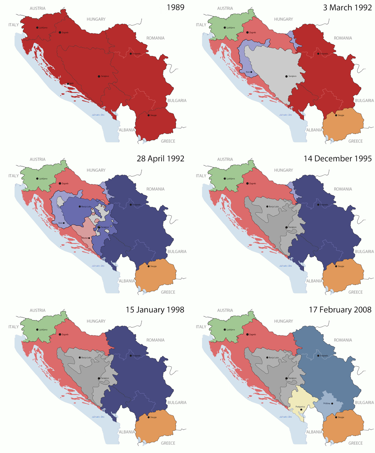
原始檔案(1,545 × 1,242 像素,檔案大小:187 KB,MIME 類型:image/gif、​循環、​14 畫格、​44秒)


该图像可使用矢量图形重新创建为SVG文件。这有很多好处;更多信息请参见共享资源:待清理媒体。如果存在此图片的SVG格式,请将其上传,然后将此模板替换为{{vector version available|新图片名称}}。 建议您将SVG命名为“Breakup of Yugoslavia.svg”,这样在使用Vector version available(或Vva)模板时就不需要填写新图片名称参数。

摘要

Key:

Yugoslavia (1943–1992) SFR Yugoslavia
Croatia (1991–present) Croatia
Herzeg-Bosnia (1992–1994)
UNTAES (1996–1998)
Federal Republic of Yugoslavia / Serbia and Montenegro (1992–2006) Serbia and Montenegro
Republika Srpska (1992–present) Republika Srpska
Serbian Krajina (1991–1995/96)
Republic of Bosnia and Herzegovina (1992–1995)
Bosnia and Herzegovina (1998–present) Bosnia and Herzegovina
Western Bosnia (1993–1995)
Serbia (2006–present) Serbia
Kosovo (under UNMIK control 1999–present; declaration of independence 2008) Kosovo
Montenegro (2006–present) Montenegro
Macedonia (1991–present) Macedonia
Slovenia (1991–present) Slovenia


描述

This is an animated GIF that shows the stages of the breakup of the SFR Yugoslavia in the 90's and 2000's. The map based off Morwen's map of the divisions of the SFRY, Which is licensed by the GFDL. The source for the dates of independence is the CIA World Factbook. These maps do not now show the Inter-Entity Boundary Line (IEBL) and/or the entities that are separated by it. The IEBL has been drawn based on this CIA map; the Brčko District has been drawn based on Image:BH municipality location.gif, by user:Ante Perkovic. I might add them in the future.

Since the original map was GFDL, this image is as well.

A map depicting Kosovo's final status is ready once it takes effect.


Changelog for versions 2/3:

Here are some changes in this new build of the map:

  • The Kosovo boundary has been given a shade of red instead of the previous UN blue since they are a province of Serbia under UNIMIK control.
  • Montenegro's color has been changed to a golden shade close to what's on the flag.
  • The IEBL and the Brčko District has been redrawn because I deleted the original map; the color for the Republika Srpska is lighter.
  • The dates are at the top left hand corner of the map instead of the bottom.
  • I have taken a new approach as to the boundaries. Each part of Yugoslavia now shows the boundary on the maps starting the year they broke away. I feel this change helps readers understand the breakup better.
  • The SFRY and the FRY are in different shades since the FRY was never accepted as the successor to the former by the UN.
  • The colors for the entities of BiH have been removed as to not confuse people into thinking that they are independent states. What remains is the IEBL with both entities in green.
  • The Kosovo boundary is finally in hash marks!
  • The Brčko District has been removed. The sale is too small to show accurately.

Changelog for version 4:

  • The map is larger!
  • The image has been rebuilt to include the eastern part of FYR Macedonia.
  • The image has been updated to take in Kosovo's new status.
  • The IEBL is now a darker line.
  • Montenegro, Kosovo, and FRY/SCG/Serbia have new colors!

Changelog for version 5:

  • Rebuilt
  • Larger map: size of base image
  • Accurate Inter-Entity Boundary Line
日期 24 July 2006 (orginal upload date)
來源 Made by Hoshie; see above for more details on sources.
作者 Hoshie
其他版本

授權條款

GNU head 已授權您依據自由軟體基金會發行的無固定段落、封面文字和封底文字GNU自由文件授權條款1.2版或任意後續版本,對本檔進行複製、傳播和/或修改。該協議的副本列在GNU自由文件授權條款中。
w:zh:共享創意
姓名標示 相同方式分享
此檔案採用共享創意 姓名標示-相同方式分享 3.0 未在地化版本授權條款。
您可以自由:
  • 分享 – 複製、發佈和傳播本作品
  • 重新修改 – 創作演繹作品
惟需遵照下列條件:
  • 姓名標示 – 您必須指名出正確的製作者,和提供授權條款的連結,以及表示是否有對內容上做出變更。您可以用任何合理的方式來行動,但不得以任何方式表明授權條款是對您許可或是由您所使用。
  • 相同方式分享 – 如果您利用本素材進行再混合、轉換或創作,您必須基於如同原先的相同或兼容的條款,來分布您的貢獻成品。
已新增授權條款標題至此檔案,作為GFDL授權更新的一部份。

說明

添加單行說明來描述出檔案所代表的內容

在此檔案描寫的項目

描繪內容

沒有維基數據項目的某些值

維基媒體使用者名稱 繁體中文 (已轉換拼寫):​Hoshie
作者姓名字串 繁體中文 (已轉換拼寫):​Hoshie

著作權狀態 繁體中文 (已轉換拼寫)

有著作權 繁體中文 (已轉換拼寫)

多媒體型式 繁體中文 (已轉換拼寫)

image/gif

校驗和 繁體中文 (已轉換拼寫)

05ca2aefea8406b809968643552d5095c847a42f

斷定方法:​SHA-1 中文 (已轉換拼寫)

191,625 位元組

44

1,242 像素

1,545 像素

檔案歷史

點選日期/時間以檢視該時間的檔案版本。

最新 | 最早) 檢視(較新 10 筆 | )(10 | 20 | 50 | 100 | 250 | 500
日期/時間縮⁠圖尺寸用戶備⁠註
目前2016年7月17日 (日) 07:40於 2016年7月17日 (日) 07:40 版本的縮圖1,545 × 1,242(187 KB)מפתח-רשימהReverted to version as of 17:22, 21 August 2015 (UTC)
2015年8月21日 (五) 17:22於 2015年8月21日 (五) 17:22 版本的縮圖1,463 × 1,158(1.81 MB)BraganzaReverted to version as of 03:57, 19 January 2010
2015年8月21日 (五) 17:22於 2015年8月21日 (五) 17:22 版本的縮圖1,545 × 1,242(187 KB)BraganzaReverted to version as of 01:02, 19 December 2011
2015年8月21日 (五) 17:15於 2015年8月21日 (五) 17:15 版本的縮圖120 × 95(3 KB)Braganza03:57, 19. Jan. 2010
2011年12月19日 (一) 01:02於 2011年12月19日 (一) 01:02 版本的縮圖1,545 × 1,242(187 KB)DIREKTORAdded details
2011年7月27日 (三) 18:09於 2011年7月27日 (三) 18:09 版本的縮圖1,545 × 1,242(170 KB)DIREKTORSmall fixes
2011年7月27日 (三) 17:28於 2011年7月27日 (三) 17:28 版本的縮圖1,545 × 1,242(171 KB)DIREKTORAdded UNMIK
2011年7月27日 (三) 16:38於 2011年7月27日 (三) 16:38 版本的縮圖1,545 × 1,242(165 KB)DIREKTORDates for the last two frames.
2011年7月27日 (三) 12:10於 2011年7月27日 (三) 12:10 版本的縮圖1,545 × 1,242(149 KB)DIREKTORLighter shade for country names
2011年7月26日 (二) 16:59於 2011年7月26日 (二) 16:59 版本的縮圖1,545 × 1,242(170 KB)DIREKTORHigher res plus details
最新 | 最早) 檢視(較新 10 筆 | )(10 | 20 | 50 | 100 | 250 | 500

下列頁面有用到此檔案:

全域檔案使用狀況

以下其他 wiki 使用了這個檔案:

檢視此檔案的更多全域使用狀況

詮釋資料