File:1st-SOUSE-sensors.png
此為最大尺寸。
1st-SOUSE-sensors.png (300 × 280 像素,檔案大小:155 KB,MIME 類型:image/png)
摘要
| 描述 |
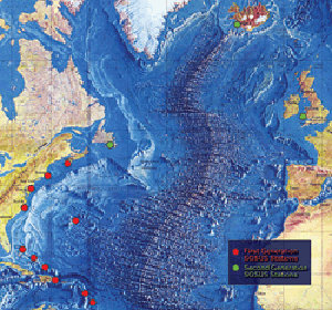
English: The first SOSUS stations – NAVFACs – were sited from Barbados to Nova Scotia on a huge semi-circle that opened onto the deepwater abyss west of the Mid-Atlantic Ridge. Later, additional Atlantic-area stations were established at Argentia, Newfoundland, Keflavik, Iceland, and Brawdy, Wales.
Polski: Pierwsze stacje Sound Surveillance System - NAVFAC rozmieszczone pomiędzy barbados i Nową Szkocją w wielkim półkolu wzdłuz wschodniego wybrzeża USA. Dodatkowe stacje rozmieszczone były miedzy Nową Fundlandią, Islandią i Walią |
| 來源 | http://www.navy.mil/navydata/cno/n87/usw/issue_25/sosus.htm (archived source) |
| 作者 | Edward C. Whitman/US Navy |
授權條款
 | ||
| 此作品無已知的著作權限制,亦不受所有相關和鄰接的權利限制。 | ||
檔案歷史
點選日期/時間以檢視該時間的檔案版本。
| 日期/時間 | 縮圖 | 尺寸 | 用戶 | 備註 | |
|---|---|---|---|---|---|
| 目前 | 2008年8月5日 (二) 00:51 | | 300 × 280(155 KB) | Matrek | {{Information |Description={{en|1=The first SOSUS stations – NAVFACs – were sited from Barbados to Nova Scotia on a huge semi-circle that opened onto the deepwater abyss west of the Mid-Atlantic Ridge. Later, additional Atlantic-area stations were est |
檔案用途
下列2個頁面有用到此檔案:
全域檔案使用狀況
以下其他 wiki 使用了這個檔案:
- en.wikipedia.org 的使用狀況
- es.wikipedia.org 的使用狀況
- et.wikipedia.org 的使用狀況
- fr.wikipedia.org 的使用狀況
- id.wikipedia.org 的使用狀況
- it.wikipedia.org 的使用狀況
- ko.wikipedia.org 的使用狀況
- pl.wikipedia.org 的使用狀況
- sv.wikipedia.org 的使用狀況
- vi.wikipedia.org 的使用狀況