File:Soulik 2013-07-12 0500Z.jpg

原始檔案(7,400 × 8,000 像素,檔案大小:12.15 MB,MIME 類型:image/jpeg


警告 部分瀏覽器在瀏覽此圖片的完整大小時可能會遇到困難:該圖片中有數量巨大的像素點,可能無法完全載入或者導致您的瀏覽器停止回應。

摘要

描述
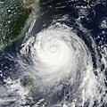
English: The Moderate Resolution Imaging Spectroradiometer (MODIS) on NASA’s Aqua satellite acquired this image of Typhoon Soulik on July 12, 2013. The storm is moving west across the Pacific Ocean on course to strike Taiwan and China in the next couple of days.

At the time the image was taken, the storm had winds of 170 kilometers per hour (90 knots or 100 miles per hour), down from its maximum strength of 230 km/hr (125 knots or 140 miles per hour) on July 10. Though Typhoon Soulik weakened significantly as it moved westward toward Taiwan, it could still cause floods, landslides, and wind damage. Taiwan’s Central Weather Bureau warned residents to brace for extremely heavy rain.

Taipei is directly in the storm’s forecasted path, and will likely be impacted on Saturday, July 13. The storm is forecast to move over eastern China on Sunday and Monday.
日期
來源 http://earthobservatory.nasa.gov/NaturalHazards/view.php?id=81627
作者 NASA image courtesy Jeff Schmaltz, LANCE/EOSDIS MODIS Rapid Response Team at NASA GSFC. Caption by Holli Riebeek.

授權條款

Public domain 本作品由NASA創作,屬於公有領域。根據NASA的版權政策:“NASA的創作除非另有聲明否則不受版權保護。”(參見:Template:PD-USGov/zhNASA版權政策JPL圖像使用政策
警告:

說明

添加單行說明來描述出檔案所代表的內容

在此檔案描寫的項目

描繪內容

檔案歷史

點選日期/時間以檢視該時間的檔案版本。

日期/時間縮⁠圖尺寸使用者備⁠註
目前2013年7月12日 (五) 19:28於 2013年7月12日 (五) 19:28 版本的縮圖7,400 × 8,000(12.15 MB)HurricaneSpinGallery version
2013年7月12日 (五) 08:15於 2013年7月12日 (五) 08:15 版本的縮圖8,250 × 8,250(6.53 MB)HurricaneSpin{{Information |Description ={{en|1=Typhoon Soulik in the Philippines Sea on July 12, 2013.}} |Source =[http://rapidfire.sci.gsfc.nasa.gov/realtime] |Author =NASA/MODIS Rapid Response System |Date =2013-07-13 |Permission ...

下列頁面有用到此檔案:

全域檔案使用狀況

以下其他 wiki 使用了這個檔案:

詮釋資料