File:Ph regions and provinces.png

預覽大小:400 × 600 像素。 其他解析度:160 × 240 像素 | 600 × 900 像素。
原始檔案 (600 × 900 像素,檔案大小:204 KB,MIME 類型:image/png)
摘要
| 描述 |
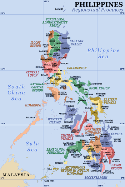
English: Map of the Philippines showing the location of all the 17 regions and 81 provinces.
Notes: The map does not depict cities that are independent of any province. It also does not depict the status of Sabah, the Spratly Islands, and Scarborough Shoal as disputed Philippine territories. Image history at en:
|
||||||||||||||||||||
| 日期 | |||||||||||||||||||||
| 來源 | 自己的作品 | ||||||||||||||||||||
| 作者 | Eugene Alvin Villar (seav) | ||||||||||||||||||||
| 其他版本 |
|

授權條款

|
If you choose to use this work under the Creative Commons license stated on this page, the author, Eugene Alvin Villar (seav), would like you to attribute the work to him (among other requirements such as indicating that the work is licensed under the Creative Commons) with the following text or similar:
© Eugene Alvin Villar, 2003
His name should be a link to his Wikimedia Commons userpage. If a link is not possible, then the url should be placed in parentheses after the name. If the work has been substantially altered by other people (see the File history section below), then this particular attribution requirement is waived, which means you can attribute the work in any reasonable manner. This attribution requirement is provided pursuant to the Creative Commons Attribution mechanism where "you must attribute the work in the manner specified by the author or licensor (but not in any way that suggests that they endorse you or your use of the work)." (See "Attribution" in the Creative Commons website.)
|
我,本作品的著作權持有者,決定用以下授權條款發佈本作品:

|
已授權您依據自由軟體基金會發行的無固定段落、封面文字和封底文字GNU自由文件授權條款1.2版或任意後續版本,對本檔進行複製、傳播和/或修改。該協議的副本列在GNU自由文件授權條款中。 |
您可以選擇您需要的授權條款。
檔案歷史
點選日期/時間以檢視該時間的檔案版本。
| 日期/時間 | 縮圖 | 尺寸 | 使用者 | 備註 | |
|---|---|---|---|---|---|
| 目前 | 2021年6月23日 (三) 08:21 | | 600 × 900(204 KB) | HueMan1 | Reverted to version as of 01:44, 23 June 2021 (UTC) |
| 2021年6月23日 (三) 07:05 |  | 600 × 900(253 KB) | 雷電1990 | Update Ver 2.0 | |
| 2021年6月23日 (三) 04:12 |  | 600 × 900(253 KB) | 雷電1990 | Reverted to version as of 18:53, 22 June 2021 (UTC) | |
| 2021年6月23日 (三) 01:44 |  | 600 × 900(204 KB) | HueMan1 | Reverted to version as of 15:31, 22 June 2021 (UTC) | |
| 2021年6月22日 (二) 18:53 |  | 600 × 900(253 KB) | 雷電1990 | Reverted to version as of 10:48, 22 June 2021 (UTC) | |
| 2021年6月22日 (二) 15:31 |  | 600 × 900(204 KB) | HueMan1 | Reverted to version as of 15:35, 25 June 2020 (UTC) | |
| 2021年6月22日 (二) 10:48 |  | 600 × 900(253 KB) | 雷電1990 | Update 2.0 | |
| 2021年6月22日 (二) 10:44 |  | 600 × 900(253 KB) | 雷電1990 | Update 2.0 | |
| 2020年6月25日 (四) 15:35 |  | 600 × 900(204 KB) | Howard the Duck | Reverted to version as of 10:29, 25 June 2020 (UTC) | |
| 2020年6月25日 (四) 10:29 |  | 600 × 900(204 KB) | Howard the Duck | Reverted to version as of 19:39, 24 June 2020 (UTC) |
檔案用途
下列2個頁面有用到此檔案:
全域檔案使用狀況
以下其他 wiki 使用了這個檔案:
- ace.wikipedia.org 的使用狀況
- ar.wikipedia.org 的使用狀況
- ast.wikipedia.org 的使用狀況
- ban.wikipedia.org 的使用狀況
- en.wikipedia.org 的使用狀況
- es.wikipedia.org 的使用狀況
- es.wikivoyage.org 的使用狀況
- eu.wikipedia.org 的使用狀況
- fa.wikipedia.org 的使用狀況
- fo.wikipedia.org 的使用狀況
- fr.wikipedia.org 的使用狀況
- gl.wikipedia.org 的使用狀況
- he.wikipedia.org 的使用狀況
- hr.wiktionary.org 的使用狀況
- hu.wikipedia.org 的使用狀況
- id.wikipedia.org 的使用狀況
檢視此檔案的更多全域使用狀況。