File:November 2009 Great Britain and Ireland floods map.svg

此 SVG 檔案的 PNG 預覽的大小:454 × 599 像素。 其他解析度:182 × 240 像素 | 364 × 480 像素 | 582 × 768 像素 | 776 × 1,024 像素 | 1,552 × 2,048 像素 | 1,800 × 2,375 像素。
原始檔案 (SVG 檔案,表面大小:1,800 × 2,375 像素,檔案大小:458 KB)
| 描述 |
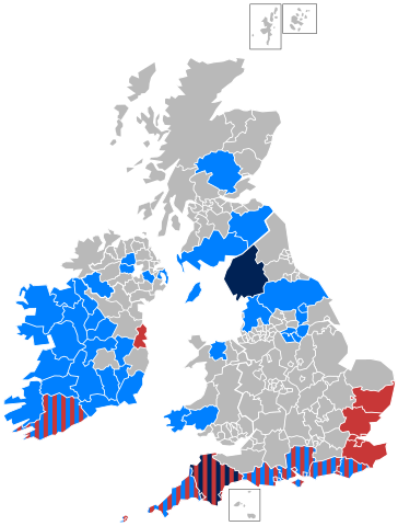
Area affected by the en:November 2009 Great Britain and Ireland floods Areas affected by flooding Death(s) affected by flooding
Areas affected by strong winds Death(s) affected by strong winds |
| 來源 | 自己的作品 |
| 作者 | AxG |
授權條款
| 我,此作品的版權所有人,釋出此作品至公共領域。此授權條款在全世界均適用。 這可能在某些國家不合法,如果是的話: 我授予任何人有權利使用此作品於任何用途,除受法律約束外,不受任何限制。 |
檔案歷史
點選日期/時間以檢視該時間的檔案版本。
| 日期/時間 | 縮圖 | 尺寸 | 使用者 | 備註 | |
|---|---|---|---|---|---|
| 目前 | 2009年12月27日 (日) 15:46 | | 1,800 × 2,375(458 KB) | Justass | Reverted to version as of 13:35, 30 November 2009 |
| 2009年12月27日 (日) 15:45 |  | 454 × 599(3 KB) | Mjroots | Additional colour for Powys and Anglesey | |
| 2009年11月30日 (一) 13:35 |  | 1,800 × 2,375(458 KB) | AxG | Update - York and North Yorkshire | |
| 2009年11月27日 (五) 19:08 |  | 1,800 × 2,375(447 KB) | Jolly Janner | Flooding in County Kildare and County Wexford. | |
| 2009年11月27日 (五) 16:46 |  | 1,800 × 2,375(447 KB) | Jolly Janner | Flooding in Offaly and Mayo. Winds in Dublin. | |
| 2009年11月23日 (一) 16:11 |  | 1,800 × 2,375(447 KB) | Jolly Janner | + Sligo and Limerick | |
| 2009年11月23日 (一) 00:42 |  | 1,800 × 2,375(447 KB) | AxG | Clean up with some new image code | |
| 2009年11月22日 (日) 22:36 |  | 1,800 × 2,375(400 KB) | Jolly Janner | Ammended some errors. | |
| 2009年11月22日 (日) 22:23 |  | 1,800 × 2,375(404 KB) | Jolly Janner | Alternative colour code. | |
| 2009年11月22日 (日) 18:41 |  | 1,800 × 2,375(368 KB) | Jolly Janner | Added Sussex per heavy rainfall and Kent per strong winds. |
檔案用途
下列頁面有用到此檔案:
全域檔案使用狀況
以下其他 wiki 使用了這個檔案:
- en.wikipedia.org 的使用狀況
- hu.wikipedia.org 的使用狀況
- nl.wikipedia.org 的使用狀況
- no.wikipedia.org 的使用狀況
- vi.wikipedia.org 的使用狀況