File:New Madrid and Wabash seizmic zones-USGS mod.png

預覽大小:547 × 599 像素。 其他解析度:219 × 240 像素 | 438 × 480 像素 | 748 × 819 像素。
原始檔案 (748 × 819 像素,檔案大小:430 KB,MIME 類型:image/png)
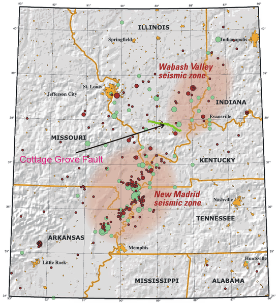
| 描述 | This map of the New Madrid and Wabash Valley seismic zones shows earthquakes as circles. Red circles indicate earthquakes that occurred from 1974 to 2002 with magnitudes larger than 2.5 located using modern instruments (University of Memphis). Green circles denote earthquakes that occurred prior to 1974 (USGS Professional Paper 1527). Larger earthquakes are represented by larger circles. The Cottage Grove Fault is indicated by the green line. |
| 日期 | (UTC) |
| 來源 | |
| 作者 |
|
| 這是一張修飾過的圖片,即本圖片是用軟體修改過後的版本,修改的方式或內容有:Added Cottage Fault。原版圖片來源:New Madrid and Wabash seizmic zones-USGS.png。修改者:Ruslik0。
|
|
|
原始上傳日誌
This image is a derivative work of the following images:
- File:New_Madrid_and_Wabash_seizmic_zones-USGS.png licensed with PD-USGov-USGS
- 2008-04-25T02:30:32Z Kbh3rd 748x819 (478218 Bytes) {{Information |Description=This map of the New Madrid and Wabash Valley seismic zones shows earthquakes as circles. Red circles indicate earthquakes that occurred from 1974 to
Uploaded with derivativeFX
檔案歷史
點選日期/時間以檢視該時間的檔案版本。
| 日期/時間 | 縮圖 | 尺寸 | 使用者 | 備註 | |
|---|---|---|---|---|---|
| 目前 | 2009年6月11日 (四) 12:10 | | 748 × 819(430 KB) | Ruslik0 | Improved version |
| 2009年6月11日 (四) 10:13 |  | 748 × 819(431 KB) | Ruslik0 | {{Information |Description=This map of the New Madrid and Wabash Valley seismic zones shows earthquakes as circles. Red circles indicate earthquakes that occurred from 1974 to 2002 with magnitudes la |
檔案用途
下列頁面有用到此檔案:
全域檔案使用狀況
以下其他 wiki 使用了這個檔案:
- en.wikipedia.org 的使用狀況
- es.wikipedia.org 的使用狀況
- pt.wikipedia.org 的使用狀況
- tr.wikipedia.org 的使用狀況
- uk.wikipedia.org 的使用狀況