File:Kansai closeup.jpg
無更高解析度可提供。
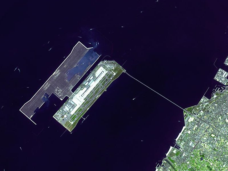
Kansai_closeup.jpg (800 × 600 像素,檔案大小:66 KB,MIME 類型:image/jpeg)
摘要
| 描述 |
Satellite image of Kansai International Airport in Osaka Bay in Japan. This is a closeup - for an overview image showing the airport on its artificial island in the bay, see Image:Wfm kansai overview.jpg |
| 日期 | |
| 來源 |
Taken from an uncopyrighted image NASA Earth Observatory |
| 作者 | NASA Earth Observatory |
| 授權許可 (重用此檔案) |
"The purpose of NASA's Earth Observatory is to provide a freely-accessible publication on the Internet where the public can obtain new satellite imagery and scientific information about our home planet. The focus is on Earth's climate and environmental change. In particular, we hope our site is useful to public media and educators. Any and all materials published on the Earth Observatory are freely available for re-publication or re-use, except where copyright is indicated. We ask that NASA's Earth Observatory be given credit for its original materials." |
| 其他版本 |

| 目標地點 | | 位於此地的本圖片與其他圖片: OpenStreetMap |
|---|
授權條款
| 本作品由NASA創作,屬於公有領域。根據NASA的版權政策:“NASA的創作除非另有聲明否則不受版權保護。”(參見:Template:PD-USGov/zh,NASA版權政策或JPL圖像使用政策) | ||
 |
警告:
|
en.Wikipedia upload log
The en.Wikipedia description page is/was here. All following user names refer to en.Wikipedia.
- 2004-04-05 19:30 Finlay McWalter 800×600 (66 KB) (nasa image of kansai airport)
檔案歷史
點選日期/時間以檢視該時間的檔案版本。
| 日期/時間 | 縮圖 | 尺寸 | 使用者 | 備註 | |
|---|---|---|---|---|---|
| 目前 | 2005年12月13日 (二) 03:46 | | 800 × 600(66 KB) | Sam916~commonswiki | Satellite image of Kansai International Airport in Osaka Bay in Japan. This is a closeup - for an overview image showing the airport on its artificial island in the bay, see Image:Wfm kansai overview.jpg Taken from an uncopyrighted imag |
檔案用途
全域檔案使用狀況
以下其他 wiki 使用了這個檔案:
- ar.wikipedia.org 的使用狀況
- ast.wikipedia.org 的使用狀況
- bbc.wikipedia.org 的使用狀況
- bg.wikipedia.org 的使用狀況
- bh.wikipedia.org 的使用狀況
- bn.wikipedia.org 的使用狀況
- de.wikipedia.org 的使用狀況
- el.wikipedia.org 的使用狀況
- en.wikipedia.org 的使用狀況
- en.wikibooks.org 的使用狀況
- es.wikipedia.org 的使用狀況
- eu.wikipedia.org 的使用狀況
- fa.wikipedia.org 的使用狀況
- fi.wikipedia.org 的使用狀況
- he.wikipedia.org 的使用狀況
- hu.wikipedia.org 的使用狀況
- id.wikipedia.org 的使用狀況
- io.wikipedia.org 的使用狀況
- it.wikipedia.org 的使用狀況
- it.wikivoyage.org 的使用狀況
- ja.wikipedia.org 的使用狀況
- ko.wikipedia.org 的使用狀況
- lfn.wikipedia.org 的使用狀況
- ml.wikipedia.org 的使用狀況
- mn.wikipedia.org 的使用狀況
- ms.wikipedia.org 的使用狀況
- nl.wikipedia.org 的使用狀況
- pt.wikipedia.org 的使用狀況
- ro.wikipedia.org 的使用狀況
- simple.wikipedia.org 的使用狀況
- sl.wikipedia.org 的使用狀況
- sr.wikipedia.org 的使用狀況
- sv.wikipedia.org 的使用狀況
- ta.wikipedia.org 的使用狀況
- uk.wikipedia.org 的使用狀況
- vi.wikipedia.org 的使用狀況
- www.wikidata.org 的使用狀況
- zh-yue.wikipedia.org 的使用狀況