File:Iron Curtain map.svg

此SVG文件的PNG预览的大小:560 × 599像素。 其他分辨率:224 × 240像素 | 449 × 480像素 | 718 × 768像素 | 957 × 1,024像素 | 1,914 × 2,048像素 | 645 × 690像素。
原始文件 (SVG文件,尺寸为645 × 690像素,文件大小:322 KB)
摘要
| 描述 |
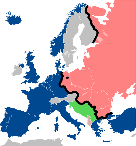
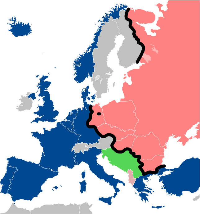
Lëtzebuergesch: Kaart vum Westen an dem Ostblock an Europa während dem Kale Krich.
"Eise Rido"
Neutral Länner
|
||
| 日期 | |||
| 来源 |
Travail personnel (own work). Sources:
|
||
| 作者 | Sémhur | ||
| 其他版本 |
File:Iron Curtain map alternative.svg (Same, but with Yugoslavia on the Eastern side of the Iron Curtain.) | ||
| 署名 (由许可协议要求) | © Sémhur / Wikimedia Commons / | ||
| SVG | W3C-validity not checked.
|
||
| Graphic Lab |

| 相机位置 | | 在以下服务上查看本图像和附近其他图像: OpenStreetMap |
|---|
许可协议
我,本作品著作权人,特此采用以下许可协议发表本作品:
| 非营利著作权:本艺术作品是自由的,您可以依据自由艺术作品许可协议的条款传播和/或修改本艺术作品。您可以在Copyleft Attitude网站或其他网站找到该许可协议的样本。 |
This file is licensed under the Creative Commons Attribution-Share Alike 4.0 International, 3.0 Unported, 2.5 Generic, 2.0 Generic and 1.0 Generic license.
- 您可以自由地:
- 共享 – 复制、发行并传播本作品
- 修改 – 改编作品
- 惟须遵守下列条件:
- 署名 – 您必须对作品进行署名,提供授权条款的链接,并说明是否对原始内容进行了更改。您可以用任何合理的方式来署名,但不得以任何方式表明许可人认可您或您的使用。
- 相同方式共享 – 如果您再混合、转换或者基于本作品进行创作,您必须以与原先许可协议相同或相兼容的许可协议分发您贡献的作品。
您可以选择您需要的许可协议。
文件历史
点击某个日期/时间查看对应时刻的文件。
| 日期/时间 | 缩略图 | 大小 | 用户 | 备注 | |
|---|---|---|---|---|---|
| 当前 | 2022年12月15日 (四) 13:26 | | 645 × 690(322 KB) | PhotographyEdits | Extend the Iron Curtain eastwards of Yugoslavia. Even though Yugoslavia was not really considered part of the West, the currenet map gives the false impression that there was a huge gap in the Iron Curtain, which wasn't the case. |
| 2022年7月23日 (六) 00:56 |  | 645 × 690(321 KB) | Kwamikagami | NATO blue, #004990 | |
| 2019年3月30日 (六) 20:30 |  | 645 × 690(321 KB) | Sémhur | Reverted to version as of 07:07, 27 May 2014 (UTC). Albania leaves the Waras Pack in middle of cold war; this is why it's shown wtih stripes. | |
| 2019年3月24日 (日) 09:18 |  | 512 × 548(123 KB) | Hakuli | Albania leaves the Waras Pack in middle of cold war | |
| 2014年5月27日 (二) 07:07 |  | 645 × 690(321 KB) | Sémhur | Valid SVG | |
| 2010年11月16日 (二) 13:51 |  | 645 × 690(321 KB) | Sémhur | Added Iron Curtain between Bulgaria and Greece & Turkey. | |
| 2008年9月27日 (六) 16:57 |  | 645 × 690(321 KB) | Sémhur | Correcting mistake : Austria wasn't in NATO. | |
| 2008年5月31日 (六) 10:51 |  | 645 × 690(330 KB) | Sémhur | {{Information |Description={{en|1=Map of the Iron Curtain in Europe.}} {{fr|1=Carte du rideau de fer en Europe.}} {{es|1=Mapa del Telón de Acero en Europa.}} |Source=Travail personnel (ow |
文件用途
全域文件用途
以下其他wiki使用此文件:
- af.wikipedia.org上的用途
- als.wikipedia.org上的用途
- ar.wikipedia.org上的用途
- ast.wikipedia.org上的用途
- azb.wikipedia.org上的用途
- az.wikipedia.org上的用途
- ba.wikipedia.org上的用途
- be-tarask.wikipedia.org上的用途
- be.wikipedia.org上的用途
- bg.wikipedia.org上的用途
- br.wikipedia.org上的用途
- bs.wikipedia.org上的用途
- ca.wikipedia.org上的用途
- cs.wikipedia.org上的用途
- cy.wikipedia.org上的用途
- da.wikipedia.org上的用途
- de.wikipedia.org上的用途
- el.wikipedia.org上的用途
- el.wiktionary.org上的用途
- en.wikipedia.org上的用途
- en.wikibooks.org上的用途
- en.wikiquote.org上的用途
- en.wiktionary.org上的用途
查看本文件的更多全域用途。