File:World map of countries by ecological footprint (2007).svg

此SVG文件的PNG预览的大小:800 × 353像素。 其他分辨率:320 × 141像素 | 640 × 283像素 | 1,024 × 452像素 | 1,280 × 565像素 | 2,560 × 1,130像素 | 940 × 415像素。
原始文件 (SVG文件,尺寸为940 × 415像素,文件大小:1.36 MB)
摘要
| 描述 |
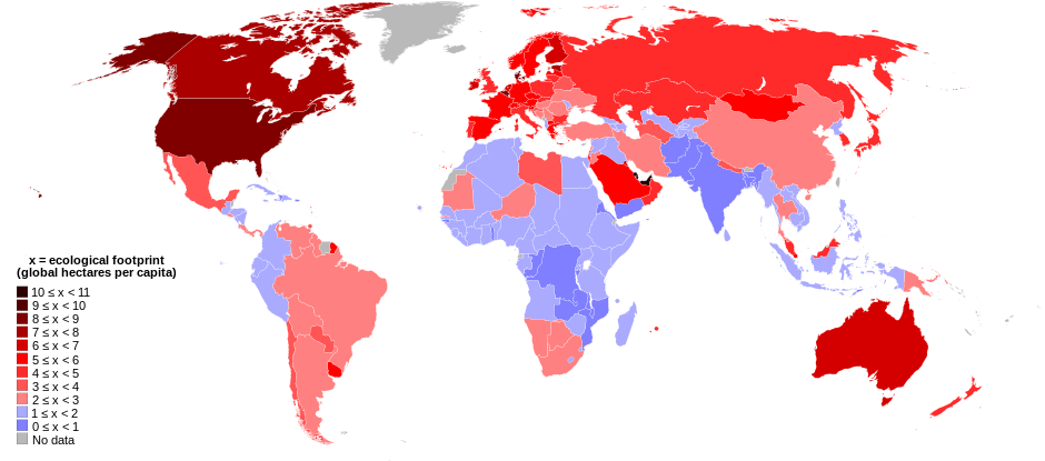
English: World map of countries shaded according to their ecological footprint in 2007 (published on 13 October 2010 by the Global Footprint Network). It is measured by the amount of global hectares that are affected by humans per capita of the country. Lighter shades denote countries with a lower ecological footprint per capita and darker shaded for countries with a higher ecological footprint per capita. The total ecological footprint (global hectares affected by humans) is measured as a total of six factors: cropland footprint, grazing footprint, forest footprint, fishing ground footprint, carbon footprint and built-up land.
Français : Mapemonde colorée selon l'empreinte écologique moyenne des habitants de chaque pays, exprimée en ha par personne, en 2007. Le tons plus chairs correspondent à une empreinte faible, les tons plus sombres à une empreinte plus forte. Six facteurs sont pris en compte pour mesurer cette empreinte: L'agriculture, le pâturage, l'exploitation forestière, la pêche, la production de carbone et l'urbanisation.
No data
0 ≤ x < 1
1 ≤ x < 2
2 ≤ x < 3
3 ≤ x < 4
4 ≤ x < 5
5 ≤ x < 6
6 ≤ x < 1
7 ≤ x < 8
8 ≤ x < 9
9 ≤ x < 10
10 ≤ x < 11 |
| 日期 | |
| 来源 | Self-made with data from list of countries by ecological footprint. |
| 作者 | Jolly Janner |
| 其他版本 |
|


.svg?uselang=zh)
.svg?uselang=zh)
.svg?action=history&uselang=zh)
.svg)
许可协议
| 我,本作品著作权人,释出本作品至公有领域。这适用于全世界。 在一些国家这可能不合法;如果是这样的话,那么: 我无条件地授予任何人以任何目的使用本作品的权利,除非这些条件是法律规定所必需的。 |
文件历史
点击某个日期/时间查看对应时刻的文件。
| 日期/时间 | 缩略图 | 大小 | 用户 | 备注 | |
|---|---|---|---|---|---|
| 当前 | 2018年3月30日 (五) 01:24 | | 940 × 415(1.36 MB) | Sisgeo | Employ a different color for countries under 2.1 gHa, the estimated limit of sustainability. |
| 2010年10月29日 (五) 18:44 |  | 940 × 415(1.68 MB) | Jolly Janner | Added a white box to represent the background | |
| 2010年10月29日 (五) 18:38 |  | 940 × 415(1.68 MB) | Jolly Janner | white background | |
| 2010年10月29日 (五) 18:36 |  | 940 × 415(1.68 MB) | Jolly Janner | white background | |
| 2010年10月29日 (五) 18:24 |  | 940 × 415(1.68 MB) | Jolly Janner | == {{int:filedesc}} == {{Information |Description={{en|1=World map of countries shaded according to their ecological footprint in 2007 (published on 13 October 2010 by the Global Footprint Network). It is measured by the amoun |
文件用途
以下页面使用本文件:
全域文件用途
以下其他wiki使用此文件:
- ca.wikipedia.org上的用途
- el.wikipedia.org上的用途
- en.wikipedia.org上的用途
- en.wikibooks.org上的用途
- eu.wikipedia.org上的用途
- fa.wikipedia.org上的用途
- fr.wikipedia.org上的用途
- gl.wikipedia.org上的用途
- hi.wikipedia.org上的用途
- it.wikipedia.org上的用途
- ms.wikipedia.org上的用途
- nl.wikipedia.org上的用途
- pl.wikipedia.org上的用途
- pl.wikibooks.org上的用途
- ro.wikipedia.org上的用途
- sk.wikipedia.org上的用途
- sr.wikipedia.org上的用途
- ta.wikipedia.org上的用途
- uk.wikipedia.org上的用途
.svg)