File:Vilnius 1576.jpg
本预览的尺寸:800 × 592像素。 其他分辨率:320 × 237像素 | 640 × 473像素 | 1,024 × 758像素 | 1,280 × 947像素 | 2,667 × 1,973像素。
原始文件 (2,667 × 1,973像素,文件大小:1.76 MB,MIME类型:image/jpeg)
| 描述 |
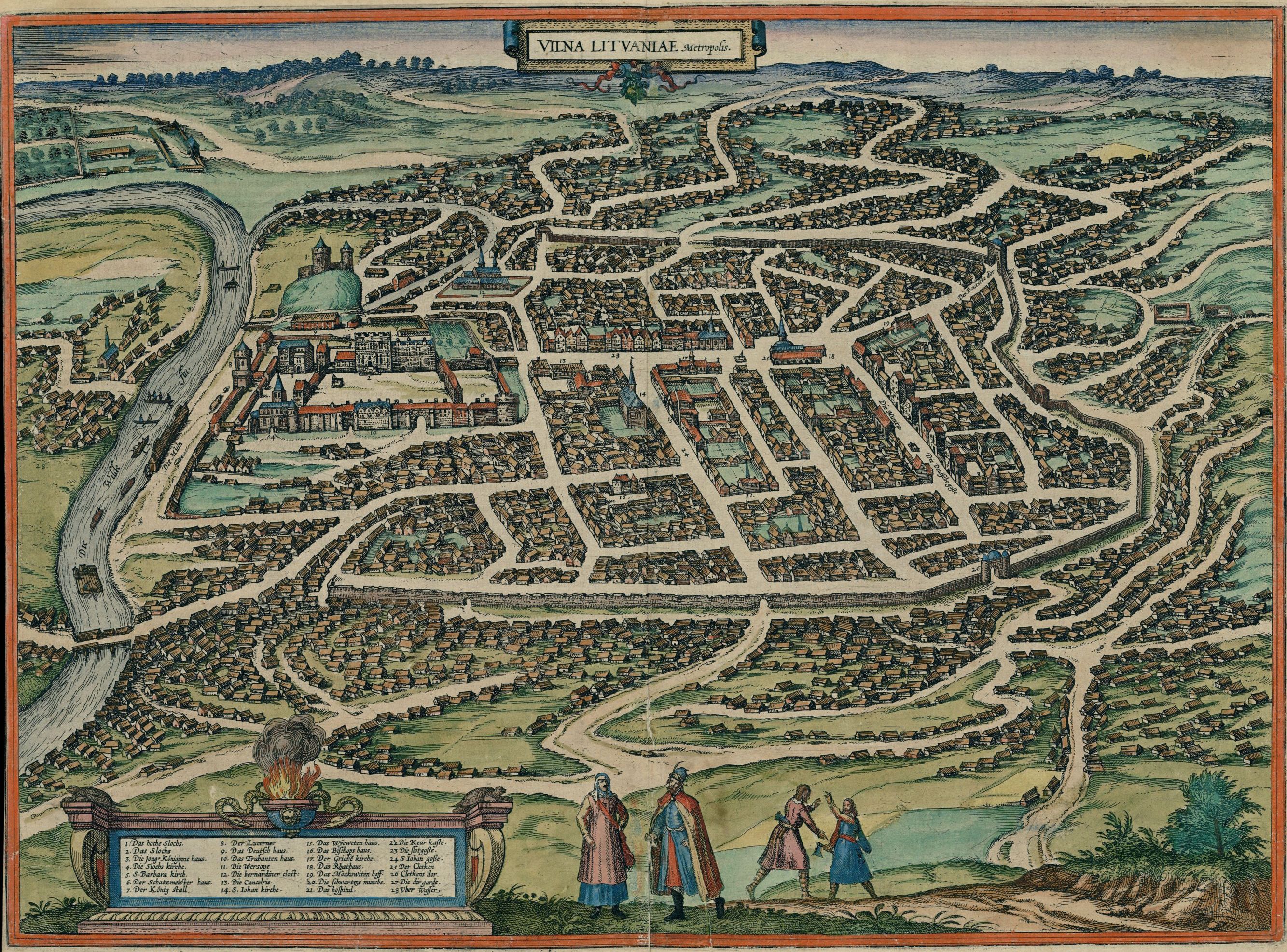
English: Map of Vilnius in 1576
Deutsch: Karte der Stadt Vilnius (als Vilna Lituaniae, Metropolis), 1576
Lietuvių: Vilniaus žemėlapis (lot. Vilna Lituaniae, Metropolis) 1576-ais metais |
| 日期 | Drawn 1576; published in 1581 |
| 来源 |
Original publication: Cities of the World (Civitates orbis terrarum. Koeln, 1581. T.3) Digital file: Historic Cities Center of the Department of Geography, the Hebrew University of Jerusalem and the Jewish National and University Library. |
| 作者 | German cartographer and church diplomat G. Braun (1541-1622) and his assistants |
| 授权 (二次使用本文件) |
public domain (pd-old) |
| 其他版本 |
 |
|
本作品在其来源国以及其他著作权期限是作者逝世后70年或以下的国家和地区属于公有领域。
| |
| 本文件已被确认为免除已知的著作权法限制(包括所有相关权利)。 | |
| 註解 | 該圖片含有註解:在維基媒體共享資源上查看註解 |
文件历史
点击某个日期/时间查看对应时刻的文件。
| 日期/时间 | 缩略图 | 大小 | 用户 | 备注 | |
|---|---|---|---|---|---|
| 当前 | 2010年12月22日 (三) 02:47 | | 2,667 × 1,973(1.76 MB) | Renata3 | http://historic-cities.huji.ac.il/lithuania/vilnius/maps/braun_hogenberg_III_59.html |
| 2009年1月18日 (日) 03:37 |  | 1,200 × 866(549 KB) | Renata3 | http://portal.unesco.org/ci/photos/showphoto.php/photo/4065/size/big | |
| 2005年4月10日 (日) 17:42 |  | 500 × 360(81 KB) | Jcornelius | *Description: Vilnius 1576 *License: public domain (pd-old) {{PD-old}} |
文件用途
以下页面使用本文件:
全域文件用途
以下其他wiki使用此文件:
- af.wikipedia.org上的用途
- azb.wikipedia.org上的用途
- be.wikipedia.org上的用途
- da.wikipedia.org上的用途
- de.wikipedia.org上的用途
- el.wikipedia.org上的用途
- en.wikipedia.org上的用途
- es.wikipedia.org上的用途
- et.wikipedia.org上的用途
- hy.wikipedia.org上的用途
- it.wikipedia.org上的用途
- lt.wikipedia.org上的用途
- lt.wikibooks.org上的用途
- lv.wikipedia.org上的用途
- nl.wikipedia.org上的用途
- nn.wikipedia.org上的用途
- no.wikipedia.org上的用途
- ru.wikipedia.org上的用途
- szy.wikipedia.org上的用途
- uk.wikipedia.org上的用途