File:Territorial-acquisition-uscensus-bureau.jpg
本预览的尺寸:756 × 599像素。 其他分辨率:303 × 240像素 | 606 × 480像素 | 969 × 768像素 | 1,280 × 1,015像素 | 1,409 × 1,117像素。
原始文件 (1,409 × 1,117像素,文件大小:333 KB,MIME类型:image/jpeg)

|
此map图片可使用矢量图形重新创建为SVG文件。这具有很多好处;更多信息请参见共享资源:待清理媒体。如果存在此图片的SVG格式,请将其上传,然后将此模板替换为
{{vector version available|新图片名称}}。
建议您将SVG命名为“Territorial-acquisition-uscensus-bureau.svg”,这样在使用Vector version available(或Vva)模板时就不需要填写新图片名称参数。 |


摘要
| 描述 |
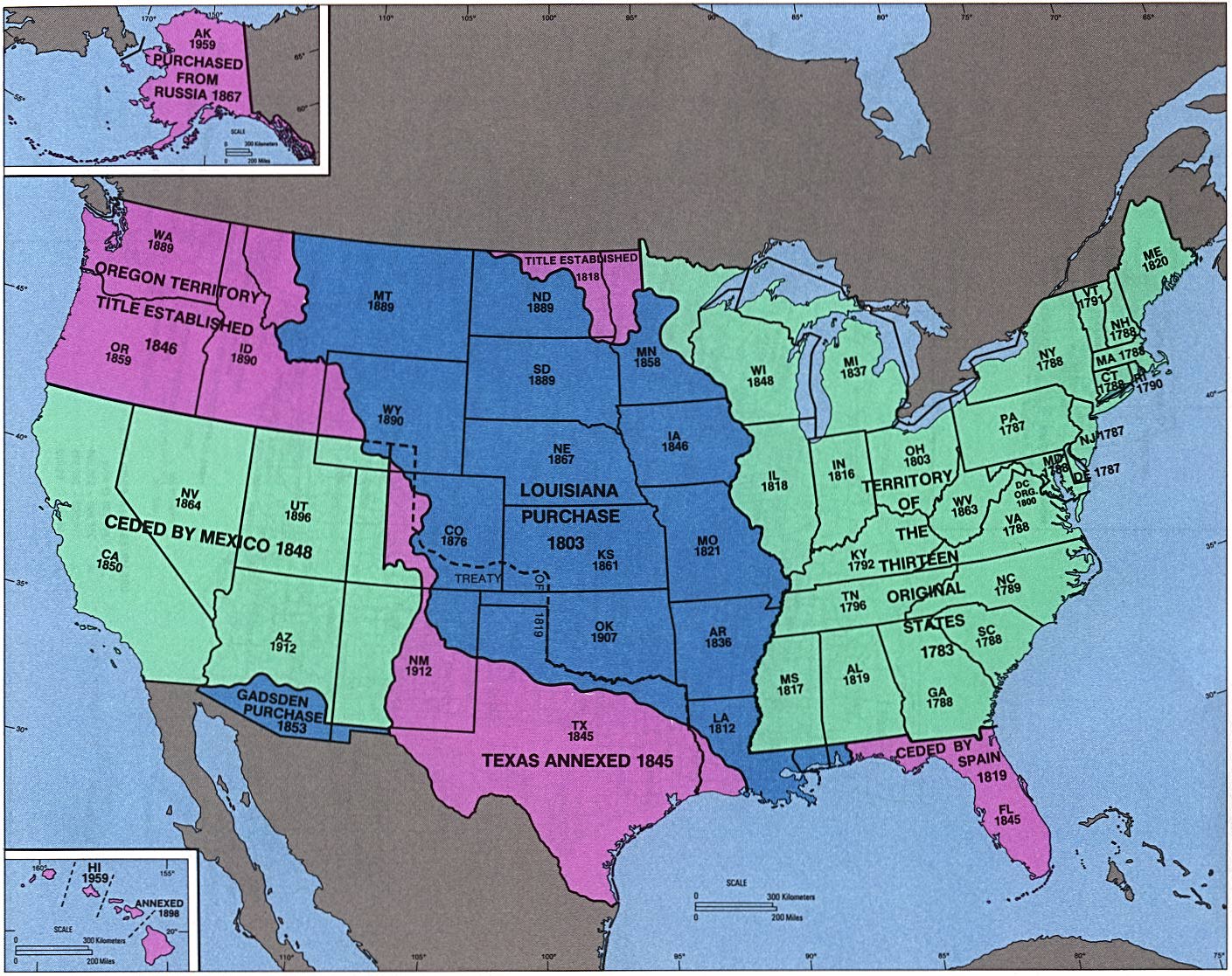
English: perry-castenada: Admission of States and Territorial Acquisition U.S. Bureau of the Census (341K) http://www.lib.utexas.edu/maps/histus.html |
| 来源 | US gov |
| 作者 | US gov |
许可协议
This image or file is a work of a United States Census Bureau employee, taken or made as part of that person's official duties. As a work of the U.S. federal government, the image is in the public domain.
|
 |
原始上传日志
原始描述頁面位於這裡。下列使用者名稱均來自en.wikipedia。
- 2004-09-30 02:05 Jengod 1409×1117×8 (341419 bytes) perry-castenada: Admission of States and Territorial Acquistion U.S. Bureau of the Census (341K) http://www.lib.utexas.edu/maps/histus.html
文件历史
点击某个日期/时间查看对应时刻的文件。
| 日期/时间 | 缩略图 | 大小 | 用户 | 备注 | |
|---|---|---|---|---|---|
| 当前 | 2008年4月18日 (五) 05:43 | | 1,409 × 1,117(333 KB) | Urdangaray | {{Information |Description={{en|perry-castenada: Admission of States and Territorial Acquisition U.S. Bureau of the Census (341K) http://www.lib.utexas.edu/maps/histus.html en:Category:Historical maps of the United States}} |Source=Transferred fro |
文件用途
以下页面使用本文件:
全域文件用途
以下其他wiki使用此文件:
- ar.wikipedia.org上的用途
- bn.wikipedia.org上的用途
- da.wikipedia.org上的用途
- de.wikipedia.org上的用途
- en.wikipedia.org上的用途
- en.wikivoyage.org上的用途
- es.wikipedia.org上的用途
- eu.wikipedia.org上的用途
- fa.wikipedia.org上的用途
- it.wikipedia.org上的用途
- ms.wikipedia.org上的用途
- pt.wikipedia.org上的用途
- ro.wikipedia.org上的用途
- sr.wikipedia.org上的用途
- sv.wikipedia.org上的用途
- vi.wikipedia.org上的用途