File:Serbia1918.png
本预览的尺寸:370 × 600像素。 其他分辨率:148 × 240像素 | 586 × 950像素。
原始文件 (586 × 950像素,文件大小:60 KB,MIME类型:image/png)
摘要
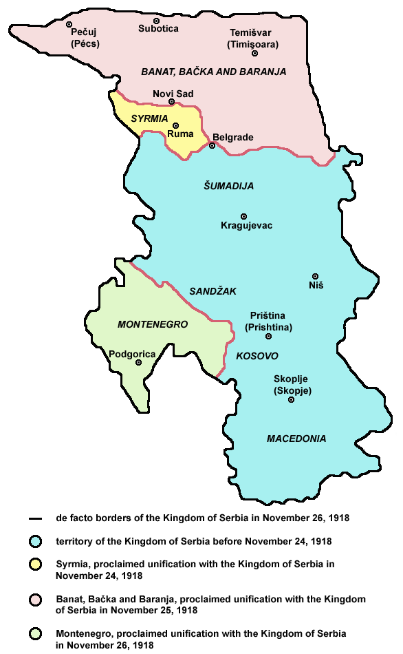
- English: de facto borders of the Kingdom of Serbia in November 26, 1918, after unification with Syrmia (November 24), Banat, Bačka and Baranja (November 25) and Montenegro (November 26), during the process of Creation of Yugoslavia.
- Serbian: фактичке границе Краљевине Србије 26. новембра 1918. године, после уједињења са Сремом (24. новембра), Банатом, Бачком и Барањом (25. новембра) и Црном Гором (26. новембра), током процеса стварања Југославије.
References
Published references:
- Drago Njegovan, Prisajedinjenje Vojvodine Srbiji, Novi Sad, 2004.
- Drago Njegovan, Prisajedinjenje Srema, Banata, Bačke i Baranje Srbiji 1918. - dokumenti i prilozi, Novi Sad, 2001.
- Lazo M. Kostić, Srpska Vojvodina i njene manjine, Novi Sad, 1999.
- Dimitrije Boarov, Politička istorija Vojvodine, Novi Sad, 2001.
- Dr Tomislav Bogavac, Nestajanje Srba, Niš, 1994.
- Čedomir Popov - Jelena Popov, Autonomija Vojvodine - srpsko pitanje, Sremski Karlovci, 2000.
- Rade Šumonja, Spomenica oslobođenja Sombora 1918-1998, Sombor, 1998.
Internet references:
许可协议

|
This map has been uploaded by Electionworld from en.wikipedia.org to enable the |
Self-made map by PANONIAN
| 本作品已被作者PANONIAN释出到公有领域。这适用于全世界。 在一些国家这可能不合法;如果是这样的话,那么: |
文件历史
点击某个日期/时间查看对应时刻的文件。
| 日期/时间 | 缩略图 | 大小 | 用户 | 备注 | |
|---|---|---|---|---|---|
| 当前 | 2009年12月24日 (四) 09:48 | | 586 × 950(60 KB) | PANONIAN | aesthetics |
| 2009年7月8日 (三) 20:01 |  | 586 × 950(60 KB) | PANONIAN | ||
| 2009年7月6日 (一) 13:49 |  | 586 × 950(60 KB) | PANONIAN | ||
| 2009年7月6日 (一) 12:01 |  | 586 × 936(56 KB) | PANONIAN | ||
| 2007年8月31日 (五) 21:13 |  | 586 × 936(52 KB) | PANONIAN | ||
| 2007年7月16日 (一) 12:08 |  | 640 × 826(16 KB) | Nihad Hamzic | Greatly reduced image size by losslessly reducing color domain. | |
| 2007年7月8日 (日) 19:13 |  | 640 × 826(42 KB) | PANONIAN | ||
| 2006年12月21日 (四) 21:38 |  | 665 × 1,050(102 KB) | Electionworld | {{ew|en|PANONIAN}} Self-made map by PANONIAN {{PD-user|PANONIAN}} Category:Maps of Serbia |
文件用途
以下页面使用本文件:
全域文件用途
以下其他wiki使用此文件:
- azb.wikipedia.org上的用途
- cs.wikipedia.org上的用途
- el.wikipedia.org上的用途
- en.wikipedia.org上的用途
- et.wikipedia.org上的用途
- fa.wikipedia.org上的用途
- fr.wikipedia.org上的用途
- gl.wikipedia.org上的用途
- he.wikipedia.org上的用途
- nl.wikipedia.org上的用途
- pnb.wikipedia.org上的用途
- pt.wikipedia.org上的用途
- ro.wikipedia.org上的用途
- sk.wikipedia.org上的用途
- sq.wikipedia.org上的用途
- sv.wikipedia.org上的用途
- th.wikipedia.org上的用途
- tr.wikipedia.org上的用途
- uk.wikipedia.org上的用途
- ur.wikipedia.org上的用途