File:RegioniIrredenteItalia.jpg
本预览的尺寸:460 × 600像素。 其他分辨率:184 × 240像素 | 632 × 824像素。
原始文件 (632 × 824像素,文件大小:247 KB,MIME类型:image/jpeg)
摘要
| 描述 |
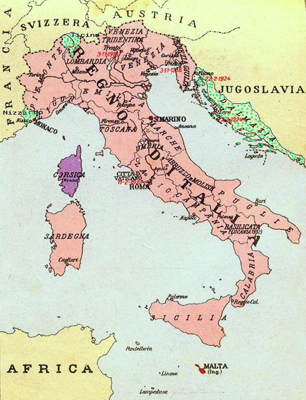
Map of Kingdom of Italy (1919) showing the areas claimed by Irredentism: in red Malta, in purple Corsica, in yellow with green points Dalmatia, Ticino and Nizzardo. I have used as a basic map an old map from an Italian geography and history school book of 1935 "Scuole Medie Inferiori", and I have written and painted on it. Cropped caption: L’Italia dopo la Guerra 1915-1918 |
| 日期 | |
| 来源 | 自己的作品 |
| 作者 | Brunodambrosio |
| 其他版本 | File:Nesvobodni rajoni Italija.png |
许可协议
| 我,本作品著作权人,释出本作品至公有领域。这适用于全世界。 在一些国家这可能不合法;如果是这样的话,那么: 我无条件地授予任何人以任何目的使用本作品的权利,除非这些条件是法律规定所必需的。 |
文件历史
点击某个日期/时间查看对应时刻的文件。
| 日期/时间 | 缩略图 | 大小 | 用户 | 备注 | |
|---|---|---|---|---|---|
| 当前 | 2023年8月17日 (四) 21:34 | | 632 × 824(247 KB) | 0m9Ep | Color |
| 2017年12月23日 (六) 10:14 |  | 632 × 824(262 KB) | Julieta39 | Blù delle mare | |
| 2012年6月7日 (四) 22:58 |  | 632 × 824(119 KB) | Ras67 | losslessly cropped with Jpegcrop | |
| 2008年4月16日 (三) 22:01 |  | 669 × 903(144 KB) | Brunodambrosio | {{Information |Description=Map of Kingdom of Italy (1919) showing the areas claimed by Irredentism:in red Malta, in purple Corsica, in yellow with green points Dalmatia, Ticino and Nizzardo. I have used as a basic map an old map from an italian geography |
文件用途
全域文件用途
以下其他wiki使用此文件:
- als.wikipedia.org上的用途
- ar.wikipedia.org上的用途
- ast.wikipedia.org上的用途
- az.wikipedia.org上的用途
- be-tarask.wikipedia.org上的用途
- be.wikipedia.org上的用途
- ca.wikipedia.org上的用途
- cs.wikipedia.org上的用途
- de.wikipedia.org上的用途
- de.wiktionary.org上的用途
- en.wikipedia.org上的用途
- Foreign relations of Italy
- Irredentism
- Italian irredentism
- History of the Kingdom of Italy (1861–1946)
- List of irredentist claims or disputes
- Italian fascism
- Kingdom of Italy
- History of Corsica
- Italian irredentism in Corsica
- Benito Mussolini
- Italian irredentism in Malta
- Italian irredentism in Switzerland
- User:Brothernight/sandbox
- eo.wikipedia.org上的用途
- es.wikipedia.org上的用途
- fa.wikipedia.org上的用途
- fr.wikipedia.org上的用途
- he.wikipedia.org上的用途
- hr.wikipedia.org上的用途
- hu.wikipedia.org上的用途
- hy.wikipedia.org上的用途
- id.wikipedia.org上的用途
查看本文件的更多全域用途。