File:Rapid transit map of Mumbai.jpg

本预览的尺寸:391 × 600像素。 其他分辨率:156 × 240像素 | 313 × 480像素 | 501 × 768像素 | 668 × 1,024像素 | 1,336 × 2,048像素 | 4,150 × 6,363像素。
原始文件 (4,150 × 6,363像素,文件大小:5.82 MB,MIME类型:image/jpeg)
摘要
| 描述 |
|
| 日期 | see file history |
| 来源 | 个人作品,使用: OpenStreetMap data for the background |
| 作者 | Maximilian Dörrbecker (Chumwa) |
| 授权 (二次使用本文件) |
All OpenStreetMap data and maps are Creative Commons "CC-BY-SA 2.0" licensed 本文件采用知识共享署名-相同方式共享 2.0 通用许可协议授权。
|
文件历史
点击某个日期/时间查看对应时刻的文件。
| 日期/时间 | 缩略图 | 大小 | 用户 | 备注 | |
|---|---|---|---|---|---|
| 当前 | 2022年4月6日 (三) 07:40 | | 4,150 × 6,363(5.82 MB) | BasilLeaf | Update - Lines 2 and 7 opened partially (Line 2 station names + Line colours need updating) |
| 2019年11月5日 (二) 07:01 |  | 4,150 × 6,363(11.74 MB) | Chumwa | erg. | |
| 2019年11月1日 (五) 16:43 |  | 4,150 × 6,363(11.71 MB) | Chumwa | erg. | |
| 2019年9月15日 (日) 17:54 |  | 4,150 × 6,363(11.7 MB) | Chumwa | ||
| 2019年9月15日 (日) 07:05 |  | 4,150 × 6,363(11.67 MB) | Chumwa | ||
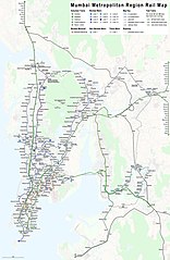
| 2019年9月14日 (六) 18:41 |  | 4,150 × 6,363(11.61 MB) | Chumwa | {{Information |Description= *{{de|1=Linienplan der Vorortzüge, U-Bahnlinien und des sonstigen Schienenverkehrs in der Metropolregion Mumbai}} *{{en|Map of all the urban, suburban, and other rail-based services in the Mumbai metropolitan region}} |Author=Maximilian Dörrbecker (Chumwa) |Source={{own using}} OpenStreetMap data for the background |Date=see file history |Permission=All OpenStreetMap data and maps are Creative Commons "CC-BY-SA 2.0" l... |
文件用途
以下页面使用本文件:
全域文件用途
以下其他wiki使用此文件:
- anp.wikipedia.org上的用途
- ar.wikipedia.org上的用途
- azb.wikipedia.org上的用途
- bn.wikipedia.org上的用途
- ca.wikipedia.org上的用途
- de.wikipedia.org上的用途
- de.wikivoyage.org上的用途
- en.wikipedia.org上的用途
- en.wikivoyage.org上的用途
- fi.wikipedia.org上的用途
- fr.wikipedia.org上的用途
- hi.wikipedia.org上的用途
- id.wikipedia.org上的用途
- it.wikipedia.org上的用途
- ja.wikipedia.org上的用途
- mr.wikipedia.org上的用途
- mt.wikipedia.org上的用途
- pl.wikipedia.org上的用途
- test.wikipedia.org上的用途
- uz.wikipedia.org上的用途
- www.wikidata.org上的用途