File:Ragusa.png
此为最大尺寸。
Ragusa.png (675 × 354像素,文件大小:128 KB,MIME类型:image/png)
摘要
| 描述 |
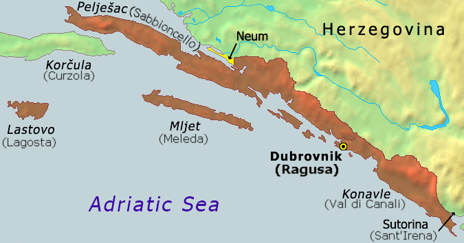
Hrvatski: Karta Dubrovačke republike iz 1808
English: Map of the Republic of Ragusa as of 1808 |
||
| 日期 | |||
| 来源 | Demis Map Server (http://www2.demis.nl/mapserver/mapper.asp) data with additional annotations and modifications by self. | ||
| 作者 | ChrisO | ||
| 其他版本 |
此文件衍生的作品: Ragusa-IT.png
|


|
此historical map图片可使用矢量图形重新创建为SVG文件。这具有很多好处;更多信息请参见共享资源:待清理媒体。如果存在此图片的SVG格式,请将其上传,然后将此模板替换为
{{vector version available|新图片名称}}。
建议您将SVG命名为“Ragusa.svg”,这样在使用Vector version available(或Vva)模板时就不需要填写新图片名称参数。 |
文件历史
点击某个日期/时间查看对应时刻的文件。
| 日期/时间 | 缩略图 | 大小 | 用户 | 备注 | |
|---|---|---|---|---|---|
| 当前 | 2020年10月21日 (三) 07:51 | | 675 × 354(128 KB) | Claude Zygiel | Ragusan / Venetian names also (official until 1918) |
| 2020年2月6日 (四) 19:49 |  | 675 × 354(114 KB) | Ceha | Klek was part of Dubrovnik Republic. Tip of the peninsula is in Croatia, while the rest is in BiH. The same goes for the small island of Lastavica, which is today in Montenegro... https://www.google.com/maps/place/Mamula/@42.3952695,18.4181714,11z/data=!4m5!3m4!1s0x134c24e629d0b6ed:0x1d78b87fc20846b1!8m2!3d42.3954043!4d18.5585609 | |
| 2010年9月8日 (三) 21:15 |  | 675 × 354(65 KB) | DIREKTOR | fix | |
| 2006年11月25日 (六) 17:02 |  | 675 × 354(53 KB) | Tieum512 | {{Information |Description=Map of the Republic of Ragusa as of 1808 Based on Demis Web Map Server output |Source=http://en.wikipedia.org/wiki/Image:Ragusa.png |Date= |Author=User:ChrisO |Permission=GFDL |other_versions= }} |
文件用途
以下页面使用本文件:
全域文件用途
以下其他wiki使用此文件:
- an.wikipedia.org上的用途
- ar.wikipedia.org上的用途
- ast.wikipedia.org上的用途
- azb.wikipedia.org上的用途
- az.wikipedia.org上的用途
- be-tarask.wikipedia.org上的用途
- be.wikipedia.org上的用途
- bg.wikipedia.org上的用途
- br.wikipedia.org上的用途
- bs.wikipedia.org上的用途
- ca.wikipedia.org上的用途
- cs.wikipedia.org上的用途
- da.wikipedia.org上的用途
- de.wikipedia.org上的用途
- el.wikipedia.org上的用途
- en.wikipedia.org上的用途
- eo.wikipedia.org上的用途
- es.wikipedia.org上的用途
- et.wikipedia.org上的用途
- eu.wikipedia.org上的用途
- fa.wikipedia.org上的用途
- fi.wikipedia.org上的用途
- fr.wikipedia.org上的用途
- fy.wikipedia.org上的用途
- gl.wikipedia.org上的用途
- he.wikipedia.org上的用途
- hu.wikipedia.org上的用途
- ia.wikipedia.org上的用途
- id.wikipedia.org上的用途
- ie.wikipedia.org上的用途
- it.wikipedia.org上的用途
- ja.wikipedia.org上的用途
- ko.wikipedia.org上的用途
- li.wikipedia.org上的用途
- mk.wikipedia.org上的用途
- ms.wikipedia.org上的用途
查看本文件的更多全域用途。