File:Map of the Kingdom of Galicia, 1914.jpg
此为最大尺寸。
Map_of_the_Kingdom_of_Galicia,_1914.jpg (598 × 450像素,文件大小:157 KB,MIME类型:image/jpeg)
{{DVG|== 摘要 ==
| 描述 |
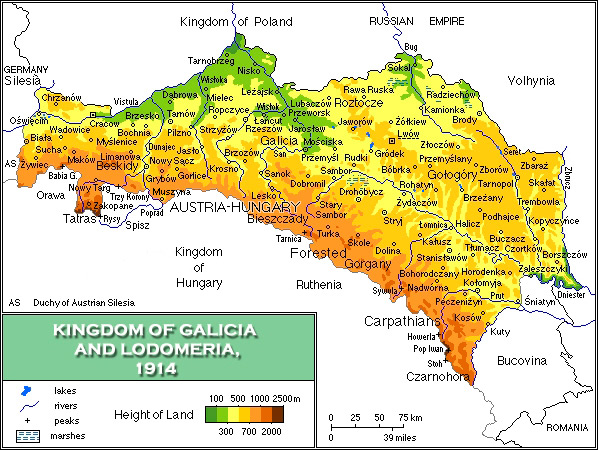
English: Map of the Kingdom of Galicia, 1914/Mapa fizyczna Galicji 1846-1918 |
| 日期 | |
| 来源 | 自己的作品 |
| 作者 | Mariusz Paździora |
| 其他版本 | image:Galicia physical1914-de.png German |

|
此historical map图片可使用矢量图形重新创建为SVG文件。这具有很多好处;更多信息请参见共享资源:待清理媒体。如果存在此图片的SVG格式,请将其上传,然后将此模板替换为
{{vector version available|新图片名称}}。
建议您将SVG命名为“Map of the Kingdom of Galicia, 1914.svg”,这样在使用Vector version available(或Vva)模板时就不需要填写新图片名称参数。 |


许可协议
我,本作品著作权人,特此采用以下许可协议发表本作品:
本文件采用知识共享署名 3.0 未本地化版本许可协议授权。
- 您可以自由地:
- 共享 – 复制、发行并传播本作品
- 修改 – 改编作品
- 惟须遵守下列条件:
- 署名 – 您必须对作品进行署名,提供授权条款的链接,并说明是否对原始内容进行了更改。您可以用任何合理的方式来署名,但不得以任何方式表明许可人认可您或您的使用。
文件历史
点击某个日期/时间查看对应时刻的文件。
| 日期/时间 | 缩略图 | 大小 | 用户 | 备注 | |
|---|---|---|---|---|---|
| 当前 | 2021年11月9日 (二) 07:13 | | 598 × 450(157 KB) | Alphathon | Corrected Bukovinan and Romanian borders |
| 2020年3月10日 (二) 09:02 |  | 598 × 450(310 KB) | Claude Zygiel | Kingdom of Poland was a part of the Russian Empire, kingdom of Hungary was a part of Austria-Hungary, and Galicia, Bucovina and Austrian Silesia were lands of the Austrian part. | |
| 2011年5月18日 (三) 18:40 |  | 598 × 450(193 KB) | VT | - Slovakia was not present then - Austria-Hungary was changed to Kingdom of Hungary: as the map shows several parts of Austro-Hungarian Monarchy, even Galicia, Bukovina and Austrian Silesia were the parts of it, not just Hungary. | |
| 2008年4月2日 (三) 18:01 |  | 598 × 450(343 KB) | Kiejstut9 | {{Information |Description=Map of the Kingdom of Galicia, 1914 |Source=self-made |Date=2008 |Author= Kiejstut9 |Permission= |other_versions= }} |
文件用途
以下页面使用本文件:
全域文件用途
以下其他wiki使用此文件:
- bg.wikipedia.org上的用途
- ca.wikipedia.org上的用途
- da.wikipedia.org上的用途
- de.wikipedia.org上的用途
- el.wikipedia.org上的用途
- en.wikipedia.org上的用途
- es.wikipedia.org上的用途
- et.wikipedia.org上的用途
- eu.wiktionary.org上的用途
- fa.wikipedia.org上的用途
- fr.wikipedia.org上的用途
- gl.wikipedia.org上的用途
- he.wikipedia.org上的用途
- hu.wikipedia.org上的用途
- it.wikipedia.org上的用途
- ja.wikipedia.org上的用途
- la.wikipedia.org上的用途
- mk.wikipedia.org上的用途
- nl.wikipedia.org上的用途
- nn.wikipedia.org上的用途
- no.wikipedia.org上的用途
- pl.wikipedia.org上的用途
- pl.wiktionary.org上的用途
- pt.wikipedia.org上的用途
- ro.wikipedia.org上的用途
- scn.wikipedia.org上的用途
- sh.wikipedia.org上的用途
- sl.wikipedia.org上的用途
- sr.wikipedia.org上的用途
- sv.wikipedia.org上的用途
- yi.wikipedia.org上的用途