File:Louisiana regions map.svg

此SVG文件的PNG预览的大小:666 × 599像素。 其他分辨率:267 × 240像素 | 534 × 480像素 | 854 × 768像素 | 1,138 × 1,024像素 | 2,276 × 2,048像素 | 5,018 × 4,515像素。
原始文件 (SVG文件,尺寸为5,018 × 4,515像素,文件大小:557 KB)
frenchjjisjisjfisf== 摘要 ==
| 描述 |
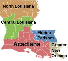
English: Map of Louisiana's regions (English) Français : Une carte des régions de la Louisiane (Anglais) |
| 日期 | |
| 来源 | Based on Image:Map of Louisiana highlighting Jefferson Davis Parish.svg, colors filled in based on data from University of Louisiana at Lafayette Center for Cultural and Eco-Tourism |
| 作者 |
许可协议
| 我,本作品著作权人,释出本作品至公有领域。这适用于全世界。 在一些国家这可能不合法;如果是这样的话,那么: 我无条件地授予任何人以任何目的使用本作品的权利,除非这些条件是法律规定所必需的。 |
文件历史
点击某个日期/时间查看对应时刻的文件。
| 日期/时间 | 缩略图 | 大小 | 用户 | 备注 | |
|---|---|---|---|---|---|
| 当前 | 2006年12月22日 (五) 09:09 | | 5,018 × 4,515(557 KB) | Interiot~commonswiki | rm stroke from small islands so they're not so invisible |
| 2006年12月21日 (四) 20:47 |  | 5,018 × 4,515(557 KB) | Interiot~commonswiki | rearrange colors again | |
| 2006年12月21日 (四) 20:36 |  | 5,018 × 4,515(557 KB) | Interiot~commonswiki | rearrange colors again | |
| 2006年12月21日 (四) 20:30 |  | 5,018 × 4,515(535 KB) | Interiot~commonswiki | change around the green and the off-gray | |
| 2006年12月21日 (四) 20:18 |  | 5,018 × 4,515(498 KB) | Interiot~commonswiki | {{SVG}} {{Information |Description=Map over Louisiana's regions |Source=Based on Image:Map of Louisiana highlighting Jefferson Davis Parish.svg, colors filled in based on data from [http://ccet.louisiana.edu/03a_Cultural_Tourism_Files/01.00_The_Land. |
文件用途
以下页面使用本文件:
全域文件用途
以下其他wiki使用此文件:
- ar.wikipedia.org上的用途
- cy.wikipedia.org上的用途
- da.wikipedia.org上的用途
- en.wikipedia.org上的用途
- en.wiktionary.org上的用途
- fi.wikipedia.org上的用途
- fr.wikipedia.org上的用途
- gl.wikipedia.org上的用途
- gu.wikipedia.org上的用途
- hu.wikipedia.org上的用途
- it.wikipedia.org上的用途
- ja.wikipedia.org上的用途
- kn.wikipedia.org上的用途
- pl.wikipedia.org上的用途
- pt.wikipedia.org上的用途
- ro.wikipedia.org上的用途
- simple.wikipedia.org上的用途
- vi.wikipedia.org上的用途