File:Lake sakakawea.jpg
本预览的尺寸:607 × 600像素。 其他分辨率:243 × 240像素 | 486 × 480像素 | 778 × 768像素 | 1,037 × 1,024像素 | 2,073 × 2,048像素 | 3,904 × 3,856像素。
原始文件 (3,904 × 3,856像素,文件大小:6.91 MB,MIME类型:image/jpeg)
摘要
| 描述 |
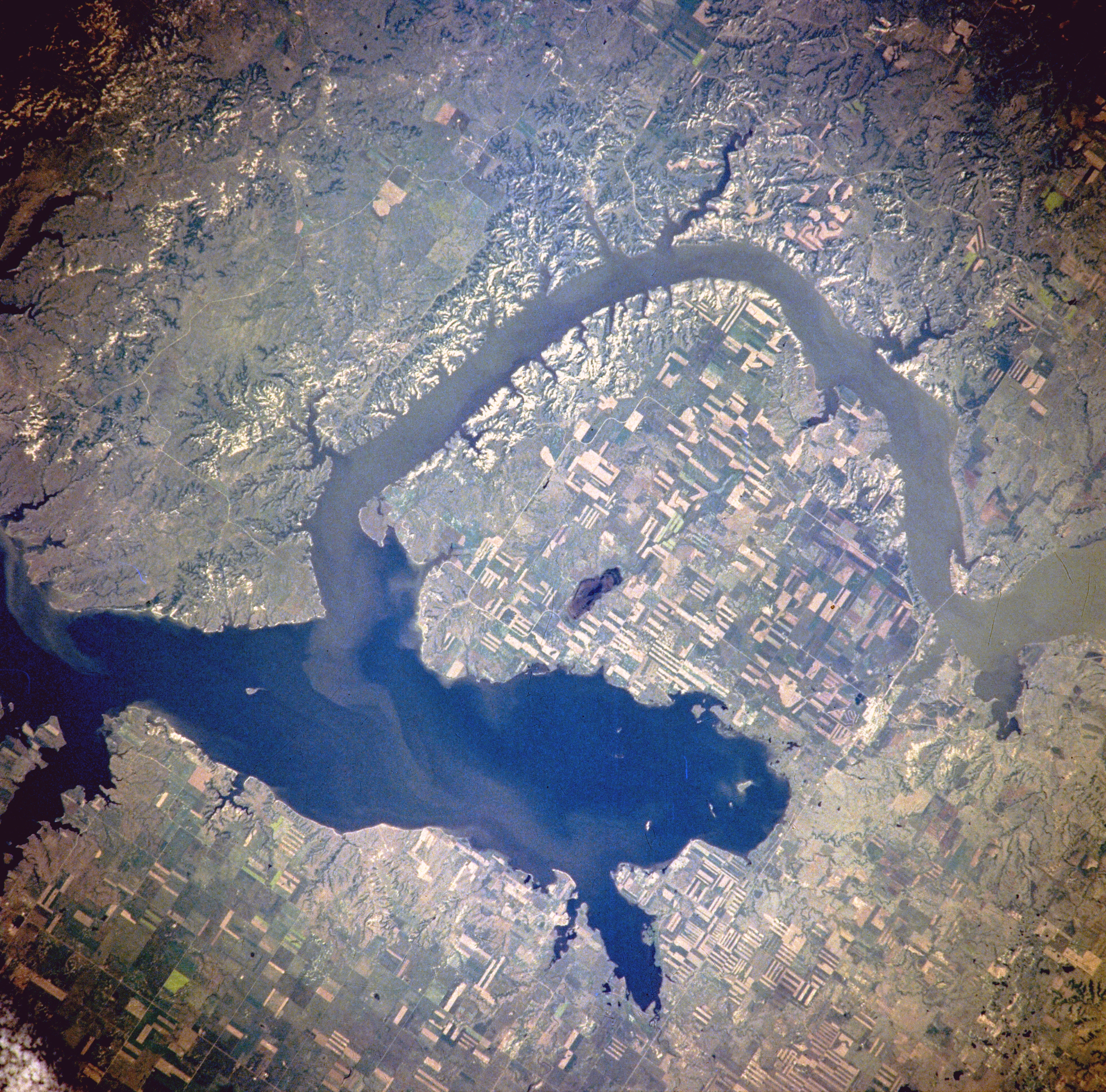
Van Hook Arm of Lake Sakakawea, North Dakota, United States - Satellite image, July 1996 The image description can be found here. The bridge on the right holds North Dakota Highway 23. North is to the right side of the image.[1] |
| 日期 | |
| 来源 | http://eol.jsc.nasa.gov/sseop/EFS/photoinfo.pl?PHOTO=NM21-765-97 |
| 作者 | NASA |
| 授权 (二次使用本文件) |
PD-LAYOUT; PD-USGOV-NASA. |
许可协议
| 本文件完全由NASA创作,在美国属于公有领域。根据NASA的版权方针,NASA的材料除非另有声明否则不受版权保护。(参见Template:PD-USGov/zh、NASA版权方针页面或JPL图片使用方针。) | ||
 |
警告:
|
原始上传日志
(All user names refer to en.wikipedia)
- 2005-08-06 21:16 Darwinek 639×632×8 (196210 bytes)
Originally from en.wikipedia; description page is/was here.
文件历史
点击某个日期/时间查看对应时刻的文件。
| 日期/时间 | 缩略图 | 大小 | 用户 | 备注 | |
|---|---|---|---|---|---|
| 当前 | 2012年2月27日 (一) 18:31 | | 3,904 × 3,856(6.91 MB) | Ras67 | high resolution |
| 2007年8月4日 (六) 13:41 |  | 639 × 632(192 KB) | Matthiasb | {{Information |Description=Van Hook Arm of Lake Sakakawea, North Dakota, United States - July 1996 The image description can be found [http://eol.jsc.nasa.gov/sseop/EFS/photoinfo.pl?PHOTO=NM21-765-97 here]. North is to the right side of the image.[http: |
文件用途
以下页面使用本文件:
全域文件用途
以下其他wiki使用此文件:
- azb.wikipedia.org上的用途
- ceb.wikipedia.org上的用途
- de.wikipedia.org上的用途
- en.wikipedia.org上的用途
- es.wikipedia.org上的用途
- fa.wikipedia.org上的用途
- fr.wikipedia.org上的用途
- it.wikipedia.org上的用途
- ru.wikipedia.org上的用途
- sr.wikipedia.org上的用途
- te.wikipedia.org上的用途
- www.wikidata.org上的用途