File:Koppen-Geiger Map Africa present.svg

此SVG文件的PNG预览的大小:800 × 474像素。 其他分辨率:320 × 190像素 | 640 × 379像素 | 1,024 × 607像素 | 1,280 × 758像素 | 2,560 × 1,516像素 | 1,435 × 850像素。
原始文件 (SVG文件,尺寸为1,435 × 850像素,文件大小:2.4 MB)
摘要
| 描述 |
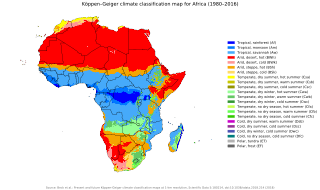
English: Köppen–Geiger climate classification map for Africa
العربية: خريطةٌ مفصّلةٌ تُصنّف أنواع المناخات في مختلفِ مناطق قارّة أفريقيا. |
| 日期 | |
| 来源 | "Present and future Köppen-Geiger climate classification maps at 1-km resolution". Nature Scientific Data. DOI:10.1038/sdata.2018.214. |
| 作者 | Beck, H.E., Zimmermann, N. E., McVicar, T. R., Vergopolan, N., Berg, A., & Wood, E. F. |
许可协议
| 相机位置 | | 在以下服务上查看本图像和附近其他图像: OpenStreetMap |
|---|
文件历史
点击某个日期/时间查看对应时刻的文件。
| 日期/时间 | 缩略图 | 大小 | 用户 | 备注 | |
|---|---|---|---|---|---|
| 当前 | 2020年1月9日 (四) 23:47 | | 1,435 × 850(2.4 MB) | AndreyKva | Optimized using SVGO. |
| 2018年11月26日 (一) 03:32 |  | 1,435 × 850(3.81 MB) | NVergopolan | {{Information |Description={{en| Köppen–Geiger climate classification map for Africa}}|date=2018-11-06|source={{cite journal | title=Present and future Köppen-Geiger climate classification maps at 1-km resolution | journal=Nature Scientific Data |doi=10.1038/sdata.2018.214}}|author=Beck, H.E., Zimmermann, N. E., McVicar, T. R., Vergopolan, N., Berg, A., & Wood, E. F.|permission=|other_versions=|other_fields=}}{{Cc-by-4.0}}{{Location|1.25920455848|19.0676026668}}[[Category:Köppen-Geiger Climat... |
文件用途
以下页面使用本文件:
全域文件用途
以下其他wiki使用此文件:
- ar.wikipedia.org上的用途
- ast.wikipedia.org上的用途
- ee.wikipedia.org上的用途
- en.wikipedia.org上的用途
- es.wikipedia.org上的用途
- fr.wikipedia.org上的用途
- gl.wikipedia.org上的用途
- ha.wikipedia.org上的用途
- ig.wikipedia.org上的用途
- lt.wikipedia.org上的用途
- ne.wikipedia.org上的用途
- sl.wikipedia.org上的用途
- sr.wikipedia.org上的用途
- tn.wikipedia.org上的用途