File:Fukushima I NPP 1975 medium crop rotated labeled.jpg

本预览的尺寸:300 × 600像素。 其他分辨率:120 × 240像素 | 240 × 480像素。
原始文件 (800 × 1,600像素,文件大小:248 KB,MIME类型:image/jpeg)
摘要
| 描述 |
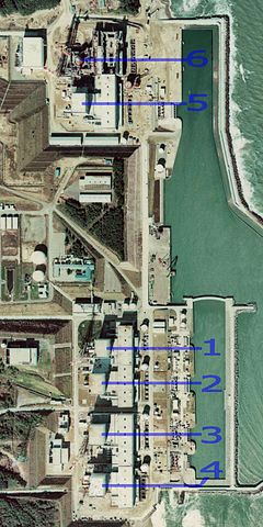
English: Fukushima I Nuclear Power Plant. Medium crop showing reactors labeled 1 to 5 and site for reactor 6. North is up.
日本語: 福島第一原子力発電所。 |
| 日期 | |
| 来源 | http://w3land.mlit.go.jp/cgi-bin/WebGIS2/WC_AirPhoto.cgi?IT=p&DT=n&PFN=CTO-75-30&PCN=C29B&IDX=21 |
| 作者 | Ministry of Land, Infrastructure, Transport and Tourism |
| 其他版本 |
|
| 相机位置 | | 在以下服务上查看本图像和附近其他图像: OpenStreetMap |
|---|
许可协议

|
本文件的著作权人,國土交通省,允许任何人在适当地表明著作权人的姓名的前提下,以任何目的使用本文件。传播,演绎作品,商业用途及所有其他用途被允许。 |
署名:
Copyright © 地图/航拍图浏览服务 国土地理院
|
 |
此图像的版权归日本地理空间信息管理局所有。请参阅地图/航空照片查看服务使用条款和来自国土交通省的消息和旅游使用条款......。当您在文章上显示此图像时,请在说明中包含以下短语:“基于[https://mapps.gsi.go.jp/maplibSearch.do#1 National Land Image Information (颜色航拍照片)],国土交通省”。
|
文件历史
点击某个日期/时间查看对应时刻的文件。
| 日期/时间 | 缩略图 | 大小 | 用户 | 备注 | |
|---|---|---|---|---|---|
| 当前 | 2011年3月15日 (二) 23:54 | | 800 × 1,600(248 KB) | 84user | =={{int:filedesc}}== {{Information |Description={{en|1=Fukushima I Nuclear Power Plant. Medium crop showing reactors labeled 1 to 5 and site for reactor 6. North is up.}} {{ja|1=[[:ja:福島第一原子力発電所| |
文件用途
以下2个页面使用本文件:
全域文件用途
以下其他wiki使用此文件:
- ar.wikipedia.org上的用途
- ast.wikipedia.org上的用途
- be-tarask.wikipedia.org上的用途
- ca.wikipedia.org上的用途
- cs.wikipedia.org上的用途
- cv.wikipedia.org上的用途
- de.wikipedia.org上的用途
- de.wikinews.org上的用途
- en.wikipedia.org上的用途
- en.wikibooks.org上的用途
- es.wikipedia.org上的用途
- fi.wikipedia.org上的用途
- fr.wikipedia.org上的用途
- gl.wikipedia.org上的用途
- he.wikipedia.org上的用途
- hi.wikipedia.org上的用途
- ja.wikipedia.org上的用途
- ko.wikipedia.org上的用途
- ko.wikinews.org上的用途
- ms.wikipedia.org上的用途
- nl.wikipedia.org上的用途
- pl.wikipedia.org上的用途
- pt.wikipedia.org上的用途
- rm.wikipedia.org上的用途
- ru.wikipedia.org上的用途
- sq.wikinews.org上的用途
- ta.wikipedia.org上的用途
- th.wikipedia.org上的用途