File:Deserts.png
本预览的尺寸:800 × 267像素。 其他分辨率:320 × 107像素 | 640 × 213像素 | 2,184 × 728像素。
原始文件 (2,184 × 728像素,文件大小:1.39 MB,MIME类型:image/png)
摘要
| 描述 |
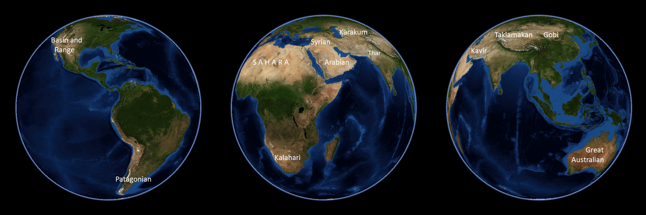
English: NASA World Wind 1.4 used. Note that the polar regions, not highlighted in this image, are the largest areas on the planet with little precipitation and are technically considered to be deserts themselves. |
| 日期 | 2009年4月5日 (原始上传日期) |
| 来源 | 本檔案是由Common Good使用CommonsHelper,從en.wikipedia轉移到維基共享資源。 |
| 作者 | 英语维基百科的Emilfaro |
| 其他版本 | العربيَّة |
许可协议
| 本作品已被作者英语维基百科的Emilfaro释出到公有领域。这适用于全世界。 在一些国家这可能不合法;如果是这样的话,那么: Emilfaro无条件地授予任何人以任何目的使用本作品的权利,除非这些条件是法律规定所必需的。 |
| 本圖像屬於公有領域,因其為NASA的World Wind衛星地圖瀏覽器的一張截圖,且使用了公有領域圖層,如Blue Marble、MODIS、Landsat、SRTM、USGS、GLOBE等。
|
 |
原始上传日志
原始描述頁面位於這裡。下列使用者名稱均來自en.wikipedia。
- 2009-04-05 10:23 Spudtater 2184×728× (1444057 bytes) Tyop
- 2009-04-05 10:21 Spudtater 2184×728× (1444046 bytes) arg!
- 2009-04-05 10:18 Spudtater 2184×728× (1444075 bytes) Tyop
- 2008-10-01 23:12 Emilfaro 2184×728× (1444046 bytes) NASA World Wind 1.4 used.
文件历史
点击某个日期/时间查看对应时刻的文件。
| 日期/时间 | 缩略图 | 大小 | 用户 | 备注 | |
|---|---|---|---|---|---|
| 当前 | 2023年9月18日 (一) 11:07 | 2,184 × 728(1.39 MB) | PadFoot2008 | Added missing Thar desert. | |
| 2009年4月7日 (二) 20:47 | 2,184 × 728(1.38 MB) | File Upload Bot (Magnus Manske) | {{BotMoveToCommons|en.wikipedia|year={{subst:CURRENTYEAR}}|month={{subst:CURRENTMONTHNAME}}|day={{subst:CURRENTDAY}}}} {{Information |Description={{en|NASA World Wind 1.4 used.}} |Source=Transferred from [http://en.wikipedia.org en.wikipedia]; transferre |
文件用途
全域文件用途
以下其他wiki使用此文件:
- ar.wikipedia.org上的用途
- azb.wikipedia.org上的用途
- az.wikipedia.org上的用途
- bg.wikipedia.org上的用途
- bn.wikipedia.org上的用途
- bs.wikipedia.org上的用途
- ca.wikipedia.org上的用途
- ckb.wikipedia.org上的用途
- de.wikipedia.org上的用途
- en.wikipedia.org上的用途
- en.wikivoyage.org上的用途
- es.wikipedia.org上的用途
- es.wikivoyage.org上的用途
- et.wikipedia.org上的用途
- eu.wikipedia.org上的用途
- fa.wikipedia.org上的用途
- fr.wikipedia.org上的用途
- hy.wikipedia.org上的用途
- hyw.wikipedia.org上的用途
- id.wikipedia.org上的用途
- ilo.wikipedia.org上的用途
- it.wikipedia.org上的用途
- ja.wikipedia.org上的用途
- kaa.wikipedia.org上的用途
- ka.wikipedia.org上的用途
- kk.wikipedia.org上的用途
- kn.wikipedia.org上的用途
- la.wikipedia.org上的用途
- lt.wikipedia.org上的用途
- ml.wikipedia.org上的用途
- mr.wikipedia.org上的用途
- ms.wikipedia.org上的用途
- my.wikipedia.org上的用途
- nn.wikipedia.org上的用途
- no.wikipedia.org上的用途
- om.wikipedia.org上的用途
- pa.wikipedia.org上的用途
- pnb.wikipedia.org上的用途
- pt.wikipedia.org上的用途
- sa.wikipedia.org上的用途
查看本文件的更多全域用途。