File:Dasht-e Lut Iran 2006-02-28 ISS012-E-18779.jpg

原始文件 (1,000 × 663像素,文件大小:237 KB,MIME类型:image/jpeg)
摘要
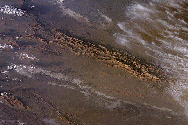
Winter in the Dasht-e-Lut Desert, eastern Iran
An International Space Station crew member took this striking photograph one evening in late February. The image takes advantage of the Sun’s low angle to reveal linear geological structures of the Iranian mountain range bordering the western edge of the basin known as Dasht-e-Lut. The range rises 1,818 meters (6,000 feet) above sea level and lies 750 kilometers (466 miles) north of the Persian Gulf. The convoluted appearance results from erosion of folded and faulted rocks—softer rocks erode away quickly, leaving more resistant rock to form linear ridges that are perpendicular to the direction of compression. While not a major oil-producing region like the Zagros Fold Belt to the southwest, the mountains of east-central Iran contain economically important deposits of copper and other metals.
Little vegetation can be seen from space in the arid interior basin of the Dasht-e-Lut. Iran is climatically part of the Afro-Asian belt of deserts that stretch from the Cape Verde islands off West Africa all the way to Mongolia near Beijing, China. The patchy, elongated, light-colored feature in the foreground (parallel to the mountain range) is the northernmost of the Dasht dry lakes that stretch southward 300 kilometers (186 miles). In near-tropical deserts, elevated areas capture most precipitation. Agricultural fields that depend on this precipitation appear as small dark patches in this image. They are located downslope, near the margin of the lake’s dry, salty soils.
Source
- http://earthobservatory.nasa.gov/Newsroom/NewImages/images.php3?img_id=17226 [1]
- http://eol.jsc.nasa.gov/scripts/sseop/photo.pl?mission=ISS012&roll=E&frame=18779
![[1]](http://earthobservatory.nasa.gov/Newsroom/NewImages/Images/ISS012-E-18779_lrg.jpg)
许可协议
| 本文件完全由NASA创作,在美国属于公有领域。根据NASA的版权方针,NASA的材料除非另有声明否则不受版权保护。(参见Template:PD-USGov/zh、NASA版权方针页面或JPL图片使用方针。) | ||
 |
警告:
|
文件历史
点击某个日期/时间查看对应时刻的文件。
| 日期/时间 | 缩略图 | 大小 | 用户 | 备注 | |
|---|---|---|---|---|---|
| 当前 | 2006年3月29日 (三) 05:52 | | 1,000 × 663(237 KB) | Pmsyyz | Dasht-e Lut, a desert in Iran |
文件用途
以下页面使用本文件:
全域文件用途
以下其他wiki使用此文件:
- ar.wikipedia.org上的用途
- az.wikipedia.org上的用途
- bg.wikipedia.org上的用途
- bn.wikipedia.org上的用途
- bs.wikipedia.org上的用途
- ca.wikipedia.org上的用途
- ckb.wikipedia.org上的用途
- cs.wikipedia.org上的用途
- de.wikipedia.org上的用途
- el.wikipedia.org上的用途
- en.wikipedia.org上的用途
- es.wikipedia.org上的用途
- et.wikipedia.org上的用途
- eu.wikipedia.org上的用途
- fa.wikipedia.org上的用途
- fi.wikipedia.org上的用途
- fr.wikipedia.org上的用途
- gd.wikipedia.org上的用途
- he.wikipedia.org上的用途
- hu.wikipedia.org上的用途
- it.wikipedia.org上的用途
- ja.wikipedia.org上的用途
- ka.wikipedia.org上的用途
- kk.wikipedia.org上的用途
- kn.wikipedia.org上的用途
- ko.wikipedia.org上的用途
- ky.wikipedia.org上的用途
- lfn.wikipedia.org上的用途
- lt.wikipedia.org上的用途
- mk.wikipedia.org上的用途
- ml.wikipedia.org上的用途
- no.wikipedia.org上的用途
- pl.wikipedia.org上的用途
- pnb.wikipedia.org上的用途
- ps.wikipedia.org上的用途
- pt.wikipedia.org上的用途
查看本文件的更多全域用途。